Posted on 04/18/2022 11:34:48 AM PDT by nickcarraway
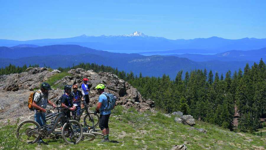
A Quincy-based nonprofit of trail builders is set to break ground on 10 miles of new trail just east of Truckee in North Lake Tahoe this spring. It’s the southernmost leg in a much larger project that aims to hook up 15 rural Sierra Nevada communities to a 600-mile network of multi-use, singletrack trail, a project called Connected Communities.
Connected Communities is a far-reaching $40 million vision. The group leading this plan, the Sierra Buttes Trail Stewardship (SBTS), is not to be underestimated. They have a proven track record of getting trails put down on the ground, trails that go on to become a stimulus for rural economies. Since 2003, SBTS has built 114 miles of new trail, maintained nearly 1,500 miles of existing trails, logged more than 100,000 volunteer hours. To date, the list of completed projects throughout the Lost Sierra numbers 121.
The Sierra Buttes Trail Stewardship is also the group behind one of the most grueling and famous downhill mountain bike races in the country, the Downieville Classic, where hundreds of riders compete on a route that descends nearly 6,000 feet from the Sierra Crest to downtown Downieville, in 26.5 miles.
Connected Communities is one of the Sierra Buttes Trail Stewardship’s most ambitious projects yet. It’s rooted in twin goals: creating more access to public lands and building a sustainable economy in the mountain communities that dot a forgotten, overlooked swath of Northern California.
Historically, towns in the Lost Sierra were built on resource extraction, first gold mining and then logging and timber. In recent decades, as the logging industry faded, tourism in the Lost Sierra grew. Over the past few years, however, the Lost Sierra has been hit by forces of nature, both the pandemic and wildfires burning through the land. Last summer, the Dixie Fire razed an entire town on the Connected Communities map, Greenville, and went on to become the largest single-source wildfire in California history. In total, the Beckwourth Complex and Dixie fires burned about 272 miles of the proposed Lost Sierra Route, the centerpiece of the Connected Communities plan.
Greenville took the heaviest loss in the Dixie Fire. Trails can help them rebuild and perhaps even come back stronger with a recreation-based economy, says Alex Terry, Connected Communities coordinator. Outdoor recreation is an $887 billion industry in the United States. Just building the trails mapped out with Connected Communities would create 150 jobs, according to SBTS.
“[Local residents] want trails and they want to rebuild a town that people want to go to and want to visit,” Terry said, talking of conversations he’s had with local residents.
“It’s still epic up here,” Terry said. “It’s still beautiful. Even though the largest single wildfire in U.S. history came through, it’s still an incredible place to live, an incredible place to come and recreate.”
As SBTS has proven that trails attract people from across the globe — bringing travelers who will then support local businesses. They’ve also shown how trails can become a centerpiece of local life, giving residents a means to engage with the surrounding public land. In a survey of 1,179 local residents and visitors to the Lost Sierra, SBTS found that the vast majority of respondents, some 94%, want more trails near their town centers. And about 88% of respondents said they’d volunteer to build and maintain new trails.
“In phase one of this project, we went out and did surveys and got public input,” said Mark Pecotich, development and marketing lead for SBTS. “Had people draw on maps, you know, where they wanted the trail to be in each town. We were very active with each of these communities to make sure the focus was about bringing people into town. And then, when they’re around town and they want to go out, the community members, they can have these recreational zones and they can go out and have different experiences, whether it’s motorized or not.”
The Lost Sierra is home to an already established through-route, the Pacific Crest Trail. But in many ways, Connected Communities seeks to offer a completely opposite experience from the Pacific Crest Trail.
The Pacific Crest Trail is a point-to-point trail, built mostly for through-hikers. It’s non-motorized, non-mechanized, meaning motorcycles and mountain biking are both prohibited on the Pacific Crest Trail. And the trail is designed to immerse hikers and equestrians in a wilderness environment, far from towns and civilization.
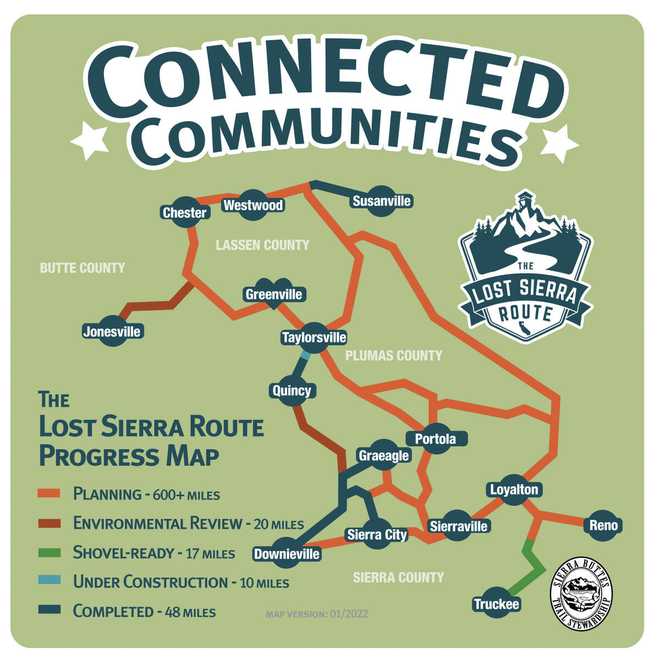
Instead of a single line running north to south, the Connected Communities trails will be a network sprawling across some 600 miles, from Truckee and Reno to Sierraville, Portola, Downieville, Quincy, Greenville, Chester, Susanville — with more towns between.
The entire point is to showcase what makes each one of those towns unique and bring people to main streets where gorgeous, quiet forests meet small town markets and restaurants.
The biggest thread, where the whole plan comes together, is the Lost Sierra Route.
Unlike the Pacific Crest Trail, the Lost Sierra Route would be a motorized, multi-use singletrack, open to mountain biking, e-biking, motorcycling, hiking, equestrian use and more. The Connected Communities map also features non-motorized multi-use trails that will branch off the Lost Sierra Route, giving hikers, mountain bikers and equestrians quieter, motorcycle-free options, too.
“We want to be able to let people choose where they want to travel and then bring people into the downtowns of those locations,” said Terry.
The whole idea is to build a trail for everyone, Pecotich said.
The East Zone project in Truckee is located near Prosser, Boca and Stampede reservoirs, close to Hirschdale and the California-Nevada state line. The northern end of the East Zone trail will link up with the Lost Sierra Route. In addition to building new trails, the Lost Sierra Route intends to use historic and existing routes, including old mining paths, railroad grades and logging flumes, according to SBTS. Some 71 miles of trail are “shovel ready,” and while the SBTS works on the first 10-mile segment this summer near Boca Reservoir in Truckee, the Tahoe National Forest will be building another 9-mile segment in the same zone. They’re hoping to make substantial progress on building the trail this summer.
Connected Communities received grant funding to make the progress it has. SBTS is seeking out more philanthropy and individual donations to support the project. SBTS is also looking ahead to bringing back the first of its signature events — huge fundraisers for trail building — since the pandemic.
Its biggest event, the Downieville Classic, was canceled in 2020 and 2021. The 2022 Downieville Classic has been postponed but is on the calendar for 2023. However, the Lost and Found Gravel Festival is coming back this year, the first weekend of June in Portola. The Lost and Found is a gravel bike ride — participants can choose between 35-, 60- and 100-mile routes. But it’s also a festival that brings families and communities together around a shared love for bikes. The event is also a chance to bring visitors back to Portola after the Dixie Fire charred the surrounding forests.
“We’re optimistic we’re going to have a great turnout. There’s been a lot of buzz in the gravel community about the event coming back,” said Pecotich. “They’re still trying to not only recover from the COVID experience, but also these massive wildfires which took out large swaths of forest.”
Ping
Looks nice, like bear country.
Crap
Don’t TELL them about these places
They’ll just show up and screw it all up like they did the BayArhhea
I’ve spent a lot of time in the triangle defined by Sierra City, Sierraville, and Graeagle. It is beautiful up there. Too bad it’s still in California.
Secession into Jefferson or Nevada is the right future for the Northern Sierra.
Trails once connected points on the map out of necessity.
Nowadays the idle NPC idiots create trails for their own amusement.
When I was young a trail was created by one person with a hatchet, often over a trail naturally created by wildlife. It was there for anyone to discover on their own to use as they might wish.
This wealthy conglomerate with non-profit 501(c) status and enriched by government grants at all levels, tax shelter donations and drives to dupe individuals into giving money to their schemes. Guess who these people vote for?
State of Jefferson territory.
Have you ever been to the "Lure Resort" in Downieville? It's a bunch of small cabins right on the river. There are shared showers and (as I recall) power in the cabins nor any kitchen. So you have a nice bed to sleep in, a roof over your head, and the river a few feet from your front door. It is a wonderful place!
We used to have family vacations on Lake Almanor in Chester. It's good to see it on this proposed trail map.
This item in the article is astonishing: "the Beckwourth Complex and Dixie fires burned about 272 miles of the proposed Lost Sierra Route.” -- that is almost HALF of the total planned route miles! Ugh.
My son and I drove to Idaho three weeks ago and driving through all the burned-out forests in Northern California starting around Lake Shasta is SO SO dismaying.
We had a record-setting 40 days above 90F last summer here in North Idaho. We are hoping this summer is more back to normal and the "smoke season" is short and mild.
I'll be back in the Bay Area tomorrow for a month. I hit the South Bay trails in February and logged 45 miles.
Graeagle is a wonderful spot. The Salmon Lakes just up the road are great, too. I remember canoeing there with our kids when they were small.
I remember a friend at work used to always have family vacations in Graeagle. We used to go up to Chester and rent a place on the peninsula jutting into Lake Almanor. That was back when California was at least semi-sane. I moved to CA in 1973 when Ronal Reagan was still the governor! I didn’t know at the time what a great man he was for the state. That was back when it was a SANE place to live.
Seems like that would be one of the largest motorized single track networks anywhere.
Thoroughly Modern Miscellany.
What’s “lost” about it? That area is overrun with tourists, hikers, campers, hunters, ranchers, and townies.
Dad, in the 1910s was raised in Chester-Westwood-Lake Almanor.
40-50-60 years ago, it was pretty remote; last time we were there, about 20 years ago, a lot of the dirt roads had been paved. On the back roads from Paradise to Butte meadows (several housing developments where we used to camp & hunt), and on to Susanville, we had a lot of traffic.
“That area is overrun with tourists, hikers, campers, hunters, ranchers, and townies.”
Unlike the Lost Coast, which is truly out in the sticks.
And nobody is there.
Almost no paved roads.
https://en.wikipedia.org/wiki/Lost_Coast
Been past Lost Coast many times on HWY-1, but never tried to actually visit it or the few tiny towns there.
(Un)Happy Camp is bustling civilization, comparatively.
https://en.wikipedia.org/wiki/Happy_Camp,_California
Don’t TELL them about these places”
40 years ago here in the mountains of NC there were ‘secret’ swimming holes and waterfalls that very few people knew about and were great for getting away from crowds.
Now they are are listed on internet hiking sites with GPS directions and are packed with people.
Unlike the Lost Coast, which is truly out in the sticks. And nobody is there.”
Except for weed growers and cults.
14 Lost Sierra towns?
“Nobody goes there any more. It’s too crowded.” - Yogi Berra................
Mark them on the maps with Deliverance avatars
Spread rumors that banjo playing cross eyed kids frequent them
and tell the HalfBacks to just keep on going back to Jersey
Disclaimer: Opinions posted on Free Republic are those of the individual posters and do not necessarily represent the opinion of Free Republic or its management. All materials posted herein are protected by copyright law and the exemption for fair use of copyrighted works.
