Free Republic
Browse · Search
News/Activism
Topics · Post Article

To: First_Salute
The Islip radar scans any given spot every 4.69 seconds.

Er, given the IE at 20:31.11.91, 4.69 seconds after that would be 20:31:16:60, where 20 = 8PM, 31 = 31 minutes, 16 = seconds, 60 = hundredths of seconds.

Using TWA800.com's same webpage, their revealing "composite radar graphic (pdf) (gif)," places the next primary radar "blip" at 20:31:46.

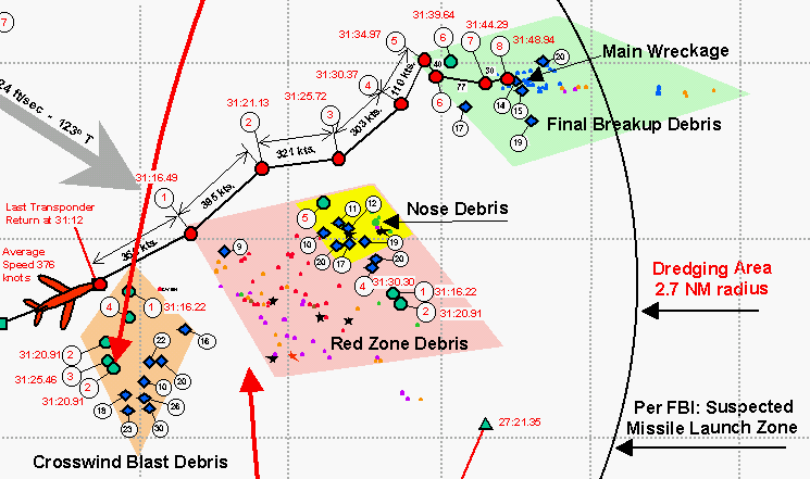
You obviously made a mistake reading that radar map (which I've already posted). The first return from Islip is the point marked as 1, which was at 20:31:16:49 (shown as 31:16:49 on the graphic for clarity).

I'll post again here for all to see..

Subtract 4.69 seconds from 31.46 seconds, and the previous primary radar "blip" calculates to 20:31:11.80, which would be just a bit earlier on TWA800.com's chart than the last transponder return at 20:31:12.00.

Uh, that's 31 minutes and 46 seconds, so 31:46 (which isn't valid as I've shown) minus 4.69 seconds would be 31:43:31...

Let me repost a little something I've already posted, and we can see just how high TWA800 was at 20:31:46.

According to the radar returns, the last return of the main body of TWA800 before it hit the water was at 8:31:48:94. Considering an error of up to 4.69 seconds due to the period of the Isplip radar sweep, TWA800 hit the water between roughly 8:31:49 to 8:31:54.

A simple physics calcultion should tell us how high TWA800 was at 21:46 if we look at the difference between that time and the time it hit the water.

Given that d = (g * t2)/2, where;
d = distance in feet
g = acceleration due to gravity = 32 feet / s2
t = time in seconds,

to find the approximate height of TWA800 at 8:31:46, we first calculate for 8:31:49, where we have a three second difference, and for 8:31:54, where we have a 8 second difference.

d = (32 * 32)/2 = 144 feet,
d = (32 * 82)/2 = 1024 feet.

So, the altitude of TWA800 was between 144 feet and 1024 feet at 8:31:46. That obviously was shortly before it hit the water...

591 posted on 08/19/2002 1:01:38 PM PDT by FormerLurker
[ Post Reply | Private Reply | To 584 | View Replies ]


To: First_Salute
So, the altitude of TWA800 was between 144 feet and 1024 feet at 8:31:46. That obviously was shortly before it hit the water...

One MAJOR reason I posted all of that was because of the infamous Asmodeus and his "time line", where he claims that at 8:31:47, there was the "Explosion of Massive Fireball" at 5500-7500 feet.

That is physically impossible, as I've shown with the calculations..

593 posted on 08/19/2002 1:09:27 PM PDT by FormerLurker
[ Post Reply | Private Reply | To 591 | View Replies ]

To: All
Hopefully everyone can understand what I meant even with the typos, of which there are several. If necessary, I'll repost the relevent section if anybody asks...
597 posted on 08/19/2002 1:30:32 PM PDT by FormerLurker
[ Post Reply | Private Reply | To 591 | View Replies ]

To: FormerLurker
The timeline and location of the major events of the disaster was approximately as follows:

8:31:11 Intact and climbing 747 approaches 13,800 feet.

8:31:12 Initiating Event at 13,800 feet followed immediately by the commencement of the decapitation process.

8:31:43-8:31:47 Streak of light appears.

8:31:47 Explosion of Massive Fireball at 5500-7500 feet.

8:31:55-8:31:57 Splashdown of the Massive Fireball flames.

The readers have now seen your huffnpuff attacks on the above timeline and The "Missile Witnesses" Myth. Please provide them with your timeline.

603 posted on 08/19/2002 7:05:51 PM PDT by Asmodeus
[ Post Reply | Private Reply | To 591 | View Replies ]

Free Republic
Browse · Search
News/Activism
Topics · Post Article


FreeRepublic, LLC, PO BOX 9771, FRESNO, CA 93794
FreeRepublic.com is powered by software copyright 2000-2008 John Robinson