
Posted on 08/26/2023 2:03:00 PM PDT by NautiNurse
I think it was a fair question, shame I got a democrat like answer from NN and attacks from others but that’s FR for ya. The fact is this thread is placing a private link on everyone’s device/history to NautiNurse.com website that could very well land someone in trouble with their husband or wife or job.
“You gotta wonder what motivates some people.”
I know right? What motivated you to butt into a conversation you weren’t a part of?
000
WTUS82 KTBW 282125
HLSTBW
FLZ043-050-052-056-057-061-139-142-148-149-151-155-160-162-165-239-242-248-249-251-255-260-262-265-290530-
Tropical Storm Idalia Local Statement Advisory Number 9
National Weather Service Tampa Bay Ruskin FL AL102023
525 PM EDT Mon Aug 28 2023
This product covers West Central and Southwest Florida
**IDALIA CONTINUES TO INTENSIFY WITH LIFE-THREATENING STORM SURGE AND
DANGEROUS WINDS LIKELY FOR PORTIONS OF FLORIDA**
NEW INFORMATION
* CHANGES TO WATCHES AND WARNINGS:
- None
* CURRENT WATCHES AND WARNINGS:
- A Storm Surge Warning and Hurricane Warning are in effect for
Coastal Citrus, Coastal Hernando, Coastal Hillsborough, Coastal
Levy, Coastal Manatee, Coastal Pasco, Inland Citrus, and
Pinellas
- A Storm Surge Warning, Tropical Storm Warning, and Hurricane
Watch are in effect for Coastal Sarasota
- A Hurricane Warning is in effect for Inland Hernando, Inland
Hillsborough, Inland Levy, Inland Manatee, Inland Pasco, and
Sumter
- A Tropical Storm Warning and Hurricane Watch are in effect for
Inland Sarasota
- A Tropical Storm Warning and Storm Surge Watch are in effect
for Coastal Charlotte and Coastal Lee
- A Tropical Storm Warning is in effect for DeSoto, Hardee,
Inland Charlotte, Inland Lee, and Polk
* STORM INFORMATION:
- About 550 miles south-southwest of Cedar Key FL or about 450
miles south-southwest of Mouth of Tampa Bay FL
- 21.4N 85.1W
- Storm Intensity 70 mph
- Movement North or 360 degrees at 8 mph
SITUATION OVERVIEW
Tropical Storm Idalia continues to intensify off of the Yucatan
Coast. Idalia is forecast to move north and eventually northeast
across the eastern Gulf of Mexico, making its way towards the Florida
peninsula and intensifying into a major hurricane. Watches and
Warnings remain in effect for West Central and Southwest Florida and
adjacent coastal waters.
The following are the primary hazards of concern with Idalia:
* Storm Surge - Areas across the Nature Coast are forecast to see
extreme life-threatening levels of storm surge, with life- threatening
surge also possible across west-central Florida. The main period of
coastal flooding looks to occur Tuesday afternoon through early
Thursday.
* Wind - Winds will increase Tuesday and remain gusty even after the
storm passes into Thursday. Hurricane force winds are possible across
much of the area and should be what residents prepare for, with
tropical storm force winds possible across the southern zones.
* Rainfall - The majority of the rainfall associated with the system
is forecast to fall Tuesday and Wednesday. A slight to moderate risk
for flooding is possible, mainly along the coast and across the
northern zones. Rainfall totals of 4 to 8 inches with locally higher
amounts up to 12 inches is possible.
POTENTIAL IMPACTS
* SURGE:
Protect against life-threatening surge having possible devastating
impacts across west central and southwest Florida. Potential impacts in
this area include:
- Widespread deep inundation, with storm surge flooding greatly
accentuated by powerful battering waves. Structural damage to
buildings, with many washing away. Damage greatly compounded
from considerable floating debris. Locations may be
uninhabitable for an extended period.
- Near-shore escape routes and secondary roads washed out or
severely flooded. Flood control systems and barriers may become
stressed.
- Extreme beach erosion. New shoreline cuts possible.
- Massive damage to marinas, docks, boardwalks, and piers.
Numerous small craft broken away from moorings with many lifted
onshore and stranded.
* WIND:
Protect against life-threatening wind having possible devastating
impacts across west central and southwest Florida. Potential impacts in
this area include:
- Structural damage to sturdy buildings, some with complete roof
and wall failures. Complete destruction of mobile homes. Damage
greatly accentuated by large airborne projectiles. Locations
may be uninhabitable for weeks or months.
- Numerous large trees snapped or uprooted along with fences and
roadway signs blown over.
- Many roads impassable from large debris, and more within urban
or heavily wooded places. Many bridges, causeways, and access
routes impassable.
- Widespread power and communications outages.
* FLOODING RAIN:
Protect against life-threatening rainfall flooding having possible
extensive impacts across west central and southwest Florida. Potential
impacts include:
- Major rainfall flooding may prompt many evacuations and rescues.
- Rivers and tributaries may rapidly overflow their banks in
multiple places. Small streams, creeks, canals, and ditches may
become dangerous rivers. Flood control systems and barriers may
become stressed.
- Flood waters can enter many structures within multiple
communities, some structures becoming uninhabitable or washed
away. Many places where flood waters may cover escape routes.
Streets and parking lots become rivers of moving water with
underpasses submerged. Driving conditions become dangerous.
Many road and bridge closures with some weakened or washed out.
* TORNADOES:
Protect against a dangerous tornado event having possible significant
impacts across west central and southwest Florida. Potential impacts
include:
- The occurrence of scattered tornadoes can hinder the execution
of emergency plans during tropical events.
- Several places may experience tornado damage with a few spots
of considerable damage, power loss, and communications failures.
- Locations could realize roofs torn off frame houses, mobile
homes demolished, boxcars overturned, large trees snapped or
uprooted, vehicles tumbled, and boats tossed about. Dangerous
projectiles can add to the toll.
PRECAUTIONARY/PREPAREDNESS ACTIONS
* EVACUATIONS:
WATCH/WARNING PHASE - Listen to local official for recommended
preparedness actions, including possible evacuation. If ordered to
evacuate, do so immediately.
WATCH/WARNING PHASE - For those not under evacuation orders, assess
the risk from wind, falling trees, and flooding at your location. If
you decide to move, relocate to a safer location nearby. If you do
not relocate, help keep roadways open for those under evacuation
orders.
WATCH/WARNING PHASE - If evacuating, leave with a destination in mind
and allow extra time to get there. Take your emergency supplies kit.
Gas up your vehicle ahead of time.
* OTHER PREPAREDNESS INFORMATION:
If heading to a community shelter, become familiar with the shelter
rules before arrival, especially if you have special needs or have
pets. Take essential items with you from your Emergency Supplies Kit.
Failure to adequately shelter may result in serious injury or loss of
life. Always heed the advice of local officials and comply with any
orders that are issued. Remember, during the storm 9 1 1 Emergency
Services may not be able to immediately respond if conditions are
unsafe. This should be a big factor in your decision making.
Storm surge is the leading killer associated with tropical storms and
hurricanes! Make sure you are in a safe area away from the surge
zone. Even if you are not in a surge-prone area, you could find
yourself cutoff by flood waters during and after the storm. Heed
evacuation orders issued by the local authorities.
* ADDITIONAL SOURCES OF INFORMATION:
- For information on appropriate preparations see ready.gov
- For information on creating an emergency plan see getagameplan.org
- For additional disaster preparedness information see redcross.org
NEXT UPDATE
The next local statement will be issued by the National Weather
Service in Tampa Bay Ruskin FL around 12 AM EDT, or sooner if
conditions warrant.
$$

I want to ride on that Red AVNI model!
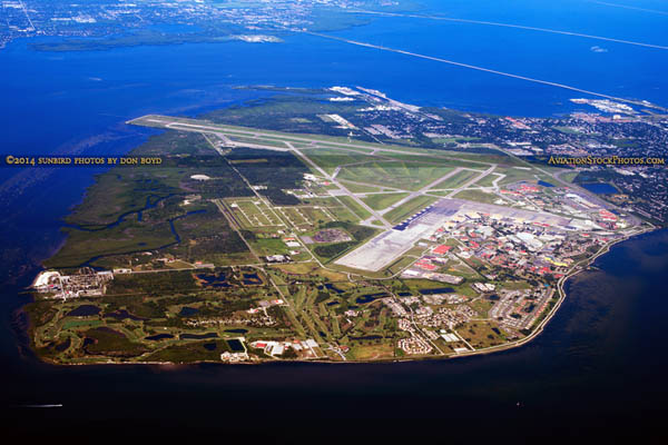
Seriously, heard MacDill closed at Noon today and will be closed tomorrow. Except for emergency personnel..
Bttt

Mash image to enlarge
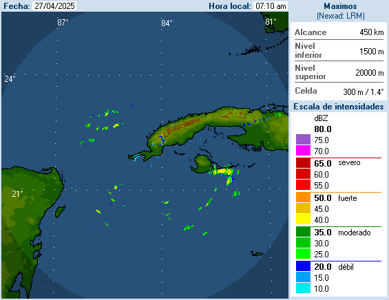
Cuba Radar
Thanks for the hard work on these storms. Had property dead on for Harvey, got very lucky plus wife insisting building to latest code.
Hope and don’t think this one will be that bad.
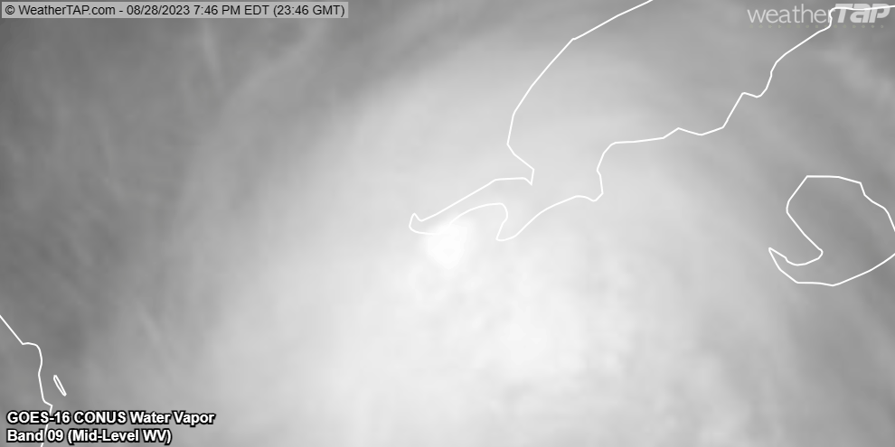
Holy crap, that convection popped.
Another view of it here:
Off to ZzzzZz...up at 4.
Ha! Have the Clash in my head, “Should I stay or should I go?”
See you tomorrow, FRiend!
Thanks for all your hard work of informing us or me who is clueless about the nature of hurricanes.
Watching this one as my sister and family recently moved to St. Augustine which looks like won’t be in the thick of things, thankfully.
Prayers up for all who are in the path of Idalia.🙏
Okay song, not my favorite . Hope you are not in a maybe move out spot. I hate those. Do you gather up papers (passport, etc), old pets and go to an in inland motel or stay put to ride out?
Did the hotel gig for Ian. Hotels were booked up when I checked last night. So...thinking about riding out the storm at home or driving across the state to visit Mom.
Whatever you decide, stay safe!
I’m staying put for now. I’ll see what the water looks like tomorrow night-ish.
Thanks for keeping the thread, all the hurricane threads, going. I’m probably out of harms way, but I have kin in Florida.
Disclaimer: Opinions posted on Free Republic are those of the individual posters and do not necessarily represent the opinion of Free Republic or its management. All materials posted herein are protected by copyright law and the exemption for fair use of copyrighted works.