Skip to comments.
Lava From Kilauea Volcano Reaches Well at Geothermal Power Plant
https://gizmodo.com ^
| 5/28/18
| George Dvorsky
Posted on 05/28/2018 9:36:32 AM PDT by BBell
click here to read article
Navigation: use the links below to view more comments.
first previous 1-20, 21-40, 41-60, 61 next last
To: caww
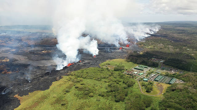
Lava inundates one of the wells at the PGV well site (not pictured)...........A production well at Puna Geothermal Venture in Puna was covered by lava late Sunday afternoon, Hawaii County Civil Defense reported.
The agency said the lava came from fissures No. 21 and No. 7, which at 7:45 p.m. Sunday evening was described by Civil Defense as “fast moving” and a threat to more structures in Leilani Estates.
The well, KS-6, along with a second well about 100 yards away, have been “successfully plugged” and “are stable and secured, and are being monitored,” according to Civil Defense. Neither well is expected to release any hydrogen sulfide, a toxic gas used in the wells, the agency said.
At an afternoon media briefing in Hilo, Gov. David Ige said, “The Puna Geothermal Venture site is safe. We believe we have mitigated any risk to the community.”........ Ige said PGV employees and a task force assembled by the governor remain on site and are working to eliminate or minimize any hazards.
four wells on one of the power plant’s pads — production wells KS-5, KS-6 and KS-14, plus injection well KS-3 — “are presenting minimum interference to the lava. They’re all close to the ground and covered, so the lava should go right over them.” All are in the lava’s path, he confirmed.
Travis said KS-5 and KS-6 have been quenched and plugged with large master valves, and cinder has been put into the well cylinders as a buffer between the lava and the valves.
41
posted on
05/28/2018 12:07:11 PM PDT
by
caww
To: caww
Amazing photos! Thanks for posting them.
42
posted on
05/28/2018 12:16:00 PM PDT
by
SE Mom
(Screaming Eagle mom)
To: BBell
now it’s an exothermal plant
43
posted on
05/28/2018 1:30:11 PM PDT
by
NonValueAdded
(#DeplorableMe #BitterClinger #HillNO! #cishet #MyPresident #MAGA #Winning #covfefe)
To: Billthedrill
44
posted on
05/28/2018 3:24:10 PM PDT
by
sheana
To: BBell

“>
45
posted on
05/28/2018 3:32:53 PM PDT
by
seawolf101
(Member LES DEPLORABLES)
To: Charles Martel
You know, a second look it seems that the amount of population near the oceans might cause the outlying islands to tip over under the constant pressure of the micro pounding. The more population the more risk it seems they have.
46
posted on
05/28/2018 6:52:09 PM PDT
by
CJ Wolf
(Tag, you're it.)
To: caww
And now it looks like a cow pasture full of crap!!!
47
posted on
05/28/2018 9:09:22 PM PDT
by
Torquay
To: PAR35
Since the plant has been on line 30 YEARS - no, it didn’t trigger anything.
BTW - the plant produced a quarter of the power for the entire Big Island while burning **no** fossil fuels.
48
posted on
05/28/2018 9:40:59 PM PDT
by
ASOC
(Having humility really means one is rarely humiliated)
To: Dennis M.
The hot spot is in the same place as always. The earth’s surface is moving to the north. At some point the hot spot will create a new island south of the existing one. At the least, they maybe should have built the plant on the north side of the active zone. Although at 30 years old, I’m guessing they probably made their money off of it. Hopefully they didn’t just go through a major upgrade or something.
49
posted on
05/28/2018 9:49:01 PM PDT
by
21twelve
To: caww
At low concentrations, hydrogen sulfide smells like rotten eggs. A slightly higher concentration paralyzes the olfactory nerve removing all sense of smell. A bit higher and you die. It is "poor man's cyanide".
50
posted on
05/28/2018 10:49:19 PM PDT
by
Myrddin
To: BBell
51
posted on
05/29/2018 4:03:28 AM PDT
by
mewzilla
(Has the FBI been spying on members of Congress?)
To: Myrddin
Hawaii is getting a haze of this stuff...(Vog)...not good.
52
posted on
05/29/2018 8:15:54 AM PDT
by
caww
To: BBell
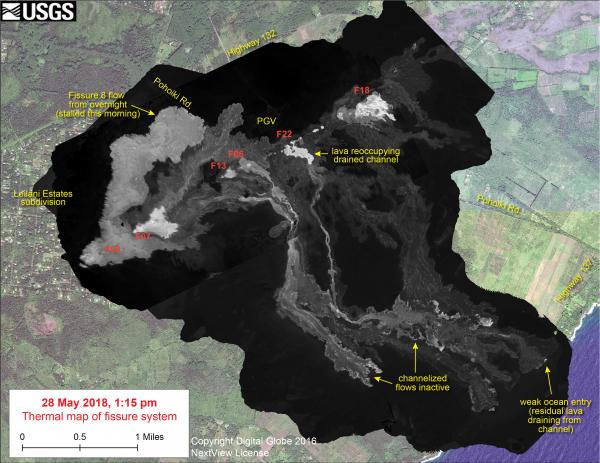
https://volcanoes.usgs.gov/observatories/hvo/maps_uploads/600x450/image-450.jpg
from link:
“This thermal map shows the fissure system and lava flows as of 1:15 pm on Monday, May 28. The flow from Fissure 8 that reached Pohoiki Rd. this morning stalled, though activity restarted at Fissure 8 in the afternoon shortly after this map was made. The channelized flows that had reached the ocean were inactive today - a small amount of residual lava was draining from the abandoned eastern channel into the ocean, creating a weak ocean entry plume. Fissure 22 restarted today with lava starting to reoccupy the drained channel. The black and white area is the extent of the thermal map. Temperature in the thermal image is displayed as gray-scale values, with the brightest pixels indicating the hottest areas. The thermal map was constructed by stitching many overlapping oblique thermal images collected by a handheld thermal camera during a helicopter overflight of the flow field. The base is a copyrighted color satellite image (used with permission) provided by Digital Globe. (see large map) “
53
posted on
05/29/2018 9:08:26 AM PDT
by
GOPJ
(Trump needs to send spies to check Democrat's campaigns - make sure dems are 'safe'...)
To: BBell
It could put out the volcano.
They shouldn’t put volcanos next to oceans.
To: BBell
Jay Furr @jayfurr 18h
@USGSVolcanoes Is it safe to roast marshmallows over volcanic vents? Assuming you had a long enough stick, that is? Or would the resulting marshmallows be poisonous? @JimGriffith_SV @DrFunkySpoon
USGS Volcanoes🌋 ✔ @USGSVolcanoes
Erm...we're going to have to say no, that's not safe. (Please don't try!) If the vent is emitting a lot of SO2 or H2S, they would taste BAD. And if you add sulfuric acid (in vog, for example) to sugar, you get a pretty spectacular reaction. 9:58 PM - May 28, 2018
55
posted on
05/29/2018 1:30:12 PM PDT
by
mrsmith
(Dumb sluts: Lifeblood of the Media, Backbone of the Democrat/RINO Party!)
To: BBell
So is this the end of the world?
56
posted on
05/29/2018 1:33:18 PM PDT
by
1Old Pro
To: 1Old Pro
57
posted on
05/29/2018 1:37:08 PM PDT
by
BBell
(calm down and eat your sandwiches)
To: ASOC
the plant produced a quarter of the power for the entire Big IslandThey must not use much electricity out there. The transformer yard doesn't look any more impressive than our neighborhood substation, and I'm not spotting any high voltage transmission lines (I found the transmission map for Oahu, but not for the island of Hawaii)
58
posted on
05/29/2018 6:14:42 PM PDT
by
PAR35
To: BBell; caww
59
posted on
05/30/2018 4:01:48 AM PDT
by
mewzilla
(Has the FBI been spying on members of Congress?)
To: caww
Yellowstone National Park is a 2 hour drive from my house. My wife and I visited often between 2003 and 2008. When the wind is still, the low lying areas accumulate hydrogen sulfide gas. There have been many incidents of bison killed by H2S under those conditions. We don't visit the park on calm days. With a good breeze, the occasional waft of rotten egg smell is encountered.
60
posted on
05/30/2018 10:31:01 AM PDT
by
Myrddin
Navigation: use the links below to view more comments.
first previous 1-20, 21-40, 41-60, 61 next last
Disclaimer:
Opinions posted on Free Republic are those of the individual
posters and do not necessarily represent the opinion of Free Republic or its
management. All materials posted herein are protected by copyright law and the
exemption for fair use of copyrighted works.
FreeRepublic.com is powered by software copyright 2000-2008 John Robinson