My sister lives inland in SC and has been watching this one.
She’s been hurricane prepped for years and has everything ready to go if they need to leave. Just throw a few bug out ready bins in the trunk of the car and they are out of there. And they live in the middle of nowhere so they can take the back roads out.
They are very well set if they can at all stay and would have nowhere better they can be. But safety first.
This storm is such a monster, I can see it maintaining it’s hurricane status much further inland than is usual for a hurricane.
We have a local meteorologist (NOT a TV met) who does private agricultural forecasting. He shares some of his knowledge with us on Facebook & when he sees major weather events, he keeps us posted. Good record of being accurate; however, when he busts a forecast, he readily admits it & explains what happened. He hates “hype” on weather events with a passion. Very interesting guy & a lot of locals depend on him instead of the TV guya. Anyway, this is what he posted @ 3:38 this morning (Sept. 6):
+++++++++++++++++++++++++++++++++++++++++++++++++++++++
***ALERT “”” SIGNIFICANT DEVELOPMENT WITH THE TRACK OF IRMA AND THE CHANGE IN THE MODELS OVERNIGHT
In case you missed it the 11 pm advisory from the Hurricane Center had IRMA moving 285 degrees or WNW Direction. This is significant because earlier on Tuesday IRMA was tracking due West. This is one of these is why many of the models have been taking IRMA very close to the big islands of Hispaniola and Cuba and then into Southern Florida. In fact the European model was actually showing a landfall in Southwest Florida somewhere between Tampa and Fort Myers.
The determination by the Hurricane Center that Irma was moving 285 degrees of West Northwest is significant because it no longer shows that West movement
But more importantly all of the models here early on Wednesday morning have shifted significantly to the east. Even the European model which as I said was the furthest most west of all the models ...now has the core of Irma staying just to the east of Miami and making landfall of Charleston South Carolina . The GFS and GFS Ensemble also solid support this shift to the east.
SUMMARY .... If this trend continues the threat of Irma making landfall in any portion of Florida is going to be greatly reduced in the next 24 to 36 hours. BUT... Significantly increases the risk for all of the Bahamas as a category 5 cane bisects the entire region.
Lastly this trend increases the risk for significant if not historic hurricane to hit South Carolina or Southeast portions of North Carolina. And it increases the rain and wind threat for much of Central and Eastern Virginia the Chesapeake Bay and the Delmarva but this depends on the track of Irma wants to make landfall.
Let’s say that IRMA makes landfall at Charleston South Carolina. If from there the hurricane would to move to Roanoke Virginia this would be tracked very similar to what we saw with Fran in 1996 and it would impact much of Western and Central North Carolina as well. But that track would not impact central eastern Virginia Eastern North Carolina very much.
But suppose Irma makes landfall at Charleston South Carolina but then heads towards Fayetteville North Carolina.. Such a Track would bring much higher winds possibly Winds to hurricane Force to eastern North Carolina and Southeast Virginia along with widespread extremely heavy rain
Like I said the shift in the weather models this early Wednesday morning along with the change in the track of the hurricane has significant locations for the entire southeast U.S. coast
++++++++++++++++++++++++++++++++++++++++++++++++++++++++++
https://www.facebook.com/WxRisk
https://www.wxrisk.com/
We were dealing with Fran 21 years ago today...
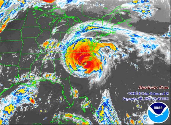
But Fran came up east of The Bahamas. What is interesting is that Fran was the second of three active storms crossing the Atlantic at the same time, the others being Eduoard and Gustav. Though it weakened considerably a couple of times and was very disorganized due to the influence of Eduoard about 800 miles ahead of her, she kept redeveloping and once Eduoard was out of the way, Fran pulled herself together and ramped up to a Cat 3 before making landfall at Cape Fear.