Posted on 08/26/2017 4:39:50 AM PDT by NautiNurse
Hurricane Harvey made landfall near Rockport TX about 10:00PM CDT Friday night. Top sustained winds were 130mph. Rockport High School sustained heavy damage when a portion of the roof collapsed. A senior housing complex collapsed. The Rockport courthouse sustained major damage with “a cargo trailer halfway in the building.” Multiple tornadoes reported in the Houston/Galveston areas. There are reports of scattered structural fires and a shooting was reported in Corpus Christi. Residents along the San Bernard River were advised to evacuate and most TX Gulf coast counties are under flash flood watches.
Many locations are under a boil-water notice. Power outages are widespread. President Donald Trump promptly granted a Disaster Declaration to Texas Governor Greg Abbott’s request. More than 700 members of the Texas Army and Air National Guards, Texas State Guard and the Texas Military Department have been activated and are positioning themselves throughout the state ahead of Hurricane Harvey and its anticipated landfall later this week. Ahead of the storm, FEMA sent supplies from its warehouse in Fort Worth to a staging point at Randolph Air Force Base near San Antonio.


Mash image to find lots of satellite imagery links
Public Advisories
Severe Weather Watches and Warnings TX
NHC Discussions
NHC Local Hurricane Statements Corpus Christi
NHC Local Hurricane Statements Galveston
Buoy Data near Harvey
Thread I: Potentially Catastrophic Hurricane Harvey Approaches Texas Gulf Coast
Reserving comment....;)
Right now, lake conroe, record 75000 cfs release
Sounds about right. Worse damage appears to be in obvious tornado tracks and storm surge. Now of course the flooding deluge.
Has anyone heard from Hollywood? Where is Sean Penn launching his boat? Have they written to song to uplift flooded homeowners? They don’t seem relevant anymore.
The fire ant flotillas hit an object and thousands begin to climb up it. Bad deal if that’s you or an animal. Worse if you are allergic to them.
I remember looking like some sort of medical experiment by the time it was all over.
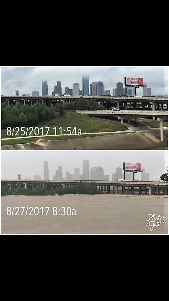
I take the sloping cement wall in front is part of a storm drainage system. Oh my, it certainly is not working this day.
They mostly make the roads act as the major flood control pathways.


Unless those driveways drop so sharply beyond the sidewalk to the street that cars would lose their front valence panels trying to drive up them, that photo is just as canned as the MSM newsreader lady in the canoe with two guys walking past in water not even past their ankles.

..."Sunday"...


Coastal areas often isolated anyway...hurricane comes thru and they go silent. Are they resting? Are they in good shape, but one major phone line down? Are they wiped off the map, screaming for help but nobody can hear?
The general trends in storm damage, including towards,and away from point if landfall, help me answer those questions.
Without a house by house, or aerial survey.
They also highlight problem areas, population centers not yet heard from. There’s almost always this...”we haven’t heard any damage reports, so they dodged a bullet” kind of overdight, potentially in play.
Adding it all up...I get a bye. I don’t need to know the difference between tornadic and hurricane wind damage. I can spot a line of significantly heavier damage if it stands out but not so well embedded in similar levels of eyewall wind effect.
Once I find a damage maxima, then a few radial points from there to “plot” change w distance, a few re-runs of the radar plot at landfall and I pretty much know where the problems are likely to be.
Then it’s a matter of searching out reports, keeping track of areas heard from and not, and plugging realtime reports into my “damage model”, updating it as needed.
He’s got a Kestrel, I believe. I’ve seen clips of him comparing it to other instruments for calibration.
During his eyewall experience, I heard him call out a couple 140 or 145s. Then the 150, which was in play for a while. Towards the end, before the stream drops.
He also had his own location plotted on a Super-Res radar display. You could see the slightly heavier return banding just inside of his position, and you kind of knew what was coming. The inner eye wasn’t too far off, but things would get worse before getting better. I think he knew it too, he didn’t specifically mention it, but you can kinda hear it in his voice, at the right time, and then things went more to hell outside and that took over till the stream dropped.
For certain the Doppler inside the car was showing hits of 140+ in that last NW quad eyewall but he said those were elevated. Kinda torn between thinking #blueshed should have succumbed to any 140+ on the ground, versus the idea of not seeing more damage during the video simply explained by a lack of stuff to tear up.
Now for the later eyewall video he moves down to Walmart and there was moderate structural damage, but mostly contained to roof elements ie a skylight nearly hit his suv.
Oh really you are saying the water is not that high and someone photo shopped it.?
Here is a news report from the say area. You can clearly see it’s flooded and very hight. Look how high the water is to the traffic lights.
https://www.youtube.com/watch?v=8hqAIheuVfc
Why do you say that? Judging by the tilt of the electric trolling motor and the prop wash, I’d say the johnboat is running in 6” to 8” of water. That’s quite feasible for a johnboat with a “tilted” trolling motor - I’ve done it myself - just not with a city street under me!
Disclaimer: Opinions posted on Free Republic are those of the individual posters and do not necessarily represent the opinion of Free Republic or its management. All materials posted herein are protected by copyright law and the exemption for fair use of copyrighted works.