
Posted on 04/08/2014 11:52:28 AM PDT by blam
This Incredible Map Shows Just How Gigantic Texas Really Is
Pamela Engel
April 8, 2014, 1:42 PM
Texans like to talk all the time about how big Texas is, and how if you're driving from the bottom of Texas to Canada, then you're spending half of your time just getting through the state itself.
So is that true? It's pretty close. Texas really is gigantic.
Redditor Armeleon put together a map that gives you a good idea of the massive size of Texas.
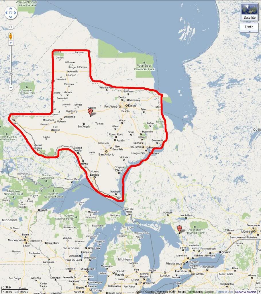
Texas spans about 800 miles from north to south. Everything seen in red on the map is closer than 791 miles to Texas (the longest straight-line distance in Texas from north to south is actually 801 miles, but Armeleon used 791 miles as a benchmark to create the map).
Check it out:
It's mind-boggling to think that, for example, Corpus Christi is closer to Cuba than it is to Denver.
It's worth noting that the map above is slightly distorted because it is flat and the world is spherical. The size and shape of objects seen on a flat map aren't exact.
(Excerpt) Read more at businessinsider.com ...

"Let's put the Longhorn Anti-Leninists of Texas in their place.........So long Lone Star State....HA HA HA HA HA HA HA HA HA HA.......You look like a tiny star set against the vast colossal sky of Mother Russia."

It is some of the most desolate, dry, parched, desolate, rocky, empty, desolate, wretched, remote, Godforsaken land I have ever seen. It'll kill you if you're not careful. Lots of mineral wealth out there, though.
That took some doing.
Most folks try to do that trip can't make it to Dumas before they pull over to the side of the road and shoot themselves.
The one that always surprise me is Maine.
I guess the huge tracts are State Forest and not Federal.
(1) Point Barrow, Alaska: 71 17 26 North
(2) Mokuhonu, Hawaii: 18 54 41 North
(3) Lubec, Maine: 44 48 49 West
(4) Attu Island, Alaska 172 28 08 EAST(!)
Alaska is two of the four.
Whatever
Frostbite Falls is a town where Bullwinkle lived. It is in the Lake in the Woods in Minnesota, the little bump at the top of Minnesota.
Reno is further west than Los Angeles.
Reno is (just) farther west than Santa Barbara ... it blows peoples’ minds ...
I think that some part of that may be owned by the lumber companies/pulp/paper industry.
As my Texan friend likes to say...she’s from the biggest state that’s thawed out.
As my Texan friend likes to say...she’s from the biggest state that’s thawed out.
Wow, this is really stupid.
A lot of us are under the impression that immigration is federal.
I am under the impression that store owners and state tuition setters go way out of their way to ignore certain people they take for granted and schmooze the heck out of the pushy foreigners.
Puleez, what does that even mean?
They both have areas where it’d be difficult to live. Both are coastal. Both have tons of natural resources.
We could go on for pages...
Disclaimer: Opinions posted on Free Republic are those of the individual posters and do not necessarily represent the opinion of Free Republic or its management. All materials posted herein are protected by copyright law and the exemption for fair use of copyrighted works.