1 posted on
03/17/2014 3:19:03 PM PDT by
BenLurkin
If anybody shoots down an innocent airliner by mistake because of the Malaysia highjacking — the Muslims will be delighted.
2 posted on
03/17/2014 3:20:08 PM PDT by
BenLurkin
(This is not a statement of fact. It is either opinion or satire; or both.)
To: BenLurkin
I spose folks notice that the Paki’s HAVE NUKES....!!!!
3 posted on
03/17/2014 3:26:11 PM PDT by
G Larry
(There's the Beef!)
To: BenLurkin; maggief; hoosiermama; LucyT; crosslink; null and void; MESHUGAMIKEY; Black Agnes
Thanks Ben lurking!
Pinging all y’all to this one! Second source!
4 posted on
03/17/2014 3:32:06 PM PDT by
WildHighlander57
((WildHighlander57, returning after lurking since 2000)
To: BenLurkin
Everyone is watching....

6 posted on
03/17/2014 3:40:12 PM PDT by
bigbob
(The best way to get a bad law repealed is to enforce it strictly. Abraham Lincoln)
To: BenLurkin
A paint job and a knowledgeable pilot who can fake it well enough to disguise the airplane as a legitimate flight long enough to get close to an intended target is all it will take.
Even if it raises suspicions no one is going to shoot down a passenger airliner until/unless there is certainty that it is a hostile.
By that time it will probably be too late.
7 posted on
03/17/2014 3:40:29 PM PDT by
Iron Munro
(Albert Einstein: The difference between stupidity and genius is that genius has its limits)
To: BenLurkin
I think it's in the Bombay doors region.. nyuk nyuk
Anyway, why would someone need a big fat slug like a 777 to deliver a nuke? Filling it with conventional explosives and full of gas would do the trick, and a sports stadium full of people would make the perfect target.
To: BenLurkin
9 posted on
03/17/2014 3:41:23 PM PDT by
no-to-illegals
(Scrutinize our government and Secure the Blessing of Freedom and Justice)
To: BenLurkin
When that other airliner disappeared about ten years ago (and was never seen again) - did Israel prepare the same way they are now?
11 posted on
03/17/2014 3:44:09 PM PDT by
Star Traveler
(Remember to keep the Messiah of Israel in the One-World Government that we look forward to coming)
To: BenLurkin
I think there are much higher value targets to be had. The 777 would be the perfect weapon to take out one of our carriers. Start at high altitude and come barreling straight down, not much to do to stop it. I really don’t know much much good the escort ships could do shooting it down.
We have carriers in the med right now, with the Ukraine thing. And I wouldn’t put it past Putin if he were behind the whole thing, diversion, scapegoat, and all that.
12 posted on
03/17/2014 3:47:21 PM PDT by
Ripliancum
(Mosiah 29:27. Look it up.)
To: BenLurkin
Ready . . Steady . .

15 posted on
03/17/2014 4:09:25 PM PDT by
tomkat
To: BenLurkin
Don’t worry Israel, mac daddy said he will draw a red line and dare any nation to cross it and suffer dire circumstances such as another red line.
There another problem solved, phew that was stressful so he will need 2 weeks vacation at tax payers expense for a bargain cost of $150,000,000.00.
21 posted on
03/17/2014 4:40:16 PM PDT by
chiefqc
To: BenLurkin
It CAN be done.
Someone sent me another piece of information you should read.
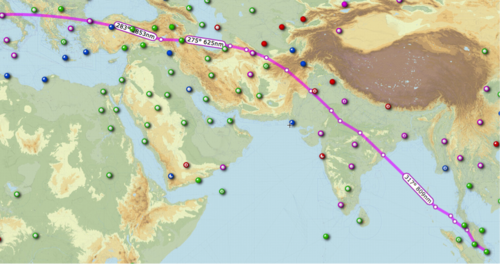
" Someone on another thread posted a link to a theory that the missing 777 used SIA68 (Singapore Airlines flight 68) to cloak their own airplane until they could get across the Indian Ocean, away from primary radar.
http://keithledgerwood.tumblr.com/post/79838944823/did-malaysian-airlines-370-disappear-using-sia68-sq68 "
That's a really good theory.
But there's problems when you try to match it with the

the arc graph (click on it for more detailed info) that shows the estimated range of the aircraft with it's remaining fuel IF it was flying at its MAXIMUM SPEED or 7 hours 30 minutes of fuel.
Now, from the article:
this statement towards the end of his article." A satellite was able to pick up a ‘ping’ from the plane until 08:11 local time,more than seven hours after it lost radar contact,
although it was unable to give a precise location.
Mr Razak went on to say that based on this new data, investigators ‘have determined the plane’s last communication with a satellite was in one of two possible corridors –north from the border of Kazakhstan and Turkmenistan through to northern Thailand,
and south from Indonesia to the southern Indian Ocean. "
My problem is ~ I don't know how accurate that Red Arc map is,
and I don't know whether to trust it or not.
I've been trying to match up the numbers on a "guess-ta-mated" flight path.
You can narrows down the search area if you take all the Satellite "Handshakes" into consideration for the search of runways/landing strips that Malaysia Airlines Flight 370 could have landed on.
The Way Point on the northwet side of her screen is "IGREX" on Jet Route "P628" where the heading changes to a more northerly direction 320 degrees to PORT BLAIR Navaid.
That's a total airborne time of about 4 hours 40 minutes from takeoff.
The arc graph shows the estimated range of the aircraft with it's remaining fuel IF it was flying at its MAXIMUM SPEED or 7 hours 30 minutes of fuel.
Now, from the article:
this statement towards the end of his article." A satellite was able to pick up a ‘ping’ from the plane until 08:11 local time,more than seven hours after it lost radar contact,
although it was unable to give a precise location.
Mr Razak went on to say that based on this new data, investigators ‘have determined the plane’s last communication with a satellite was in one of two possible corridors –north from the border of Kazakhstan and Turkmenistan through to northern Thailand,
and south from Indonesia to the southern Indian Ocean. "
That's
7 hours and 31 minutes after takeoff.
"... The plane departed for an overnight flight from Kuala Lumpur to Beijing at 12:40 a.m. on March 8.
Its communications with civilian air controllers were severed at about 1:20 a.m., and the jet went missing ... "
That leaves
2 Hours 50 minutes to travel from "IGREX" on Jet Route "P628 to an undefined point on that arc of 7 hours 30 minutes from takeoff.
Let's say that the pilot leans the engines out to get the most out of his fuel for distance with the remaining time for "IGREX" and gets 3 hours if time,
before he hits his 20 minutes safety margin on fuel and then starts to burn his 1 hour emergency fuel.
At maximum speed of Mach 0.89 (590 mph, 950 km/h, 512 knots) at a cruise altitude of 35,000 ft , that would
allow him 1770 miles of distance (to the red arc), before hitting his reserves.
Let's
assume that since he stayed on the Jet Routes, he continued to stay on the Jet Routes.
Now take that information and
the arc ping map (important to view this map at this link for more details) along with the jet route map, and you can find possible links.
Now I run the numbers on the Jet Routes starting from "IGREX" on Jet Route "P628" and starting
subtotaling for a target of 1770 Nautical Miles.Take a look from
SkyVector.com.
Jet Route P628 NW IGREX 151 NM to Port Blair
Port Blair 272 NM to VATLA
VALTA 173 NM to URKOK
URKOK 172 NM to KAGUL
KAGUL 51 NM to DORIL
DORIL 99 NM to OPASA
OPASA 75 NM to IKINA
IKINA 28 NM to OPONI
OPONI 121 NM to ASOPO or JABALPUR
-----------
1,142 NM subtotal
---------------
Change route to W66 North to KHAJURAHO
ASOPO 97 NM to KKJ
Change route to W40 NNE via KANPUR to LUCKNOW
KJJ 72 NM to IGONA
IGONA 28 NM to LUCKNOW
Change route to M890 Northwest to SARSAWA
LUCKNOW 87 NM to JALABAD
JALABAD 65 NM to PUMOT
PUMOT 116 NM to SARAWA
--------------
1,607 NM Subtotal
SARAWA 27 NM to ONOGI
ONOGI 26 NM to CHANDIGARH (CHG)
CHG 73 NM to LAKET
LAKET 49 NM to SAMAR
Change Direction North to J220 to SIALKOT (SLT) Airport
SAMAR aprx 75 NM to SIALKOT Airport
------------------
1,857 NM
Now A different Route
From M890 at SARSAWA
--------------
1,607 NM Subtotal
Change route to W39 North to LEH
SARAWA 143 NM to LELAX
LELAX 101 NM to LEH
------------
1,851 NM Subtotal
Change route, direct to HOTAN approximately 030 heading
LEH approx 145 NM to HOTAN
Change Route, via SHACHE via KASHI
HOTAN apx 150 NM to SHACHE approx 310 heading
SHACHE 68 NM via A364 to KASHI
Change Route NNW via TADOT to BISHKEK MANAS
KASHI 100 NM to TADOT approximately 350 heading
TADOT 100 NM to BISHKEK MANAS Airport, Kyrgyzstan
--------------
2,414 NM Total (might be out of range)
==============================================
My Airport of Interest are:UDHAMPUR (VIUX)
Runway [18 36] 9028.8 x 148 ft, Asphalt
Sialkot International Airport (IATA: SKT, ICAO: OPST)
Runway 22/04 11811 x 148 ASP
GILGIT (OPGT) Gilgit, Gilgit-Baltistan, Pakistan
Runway [07 25] 5385.6 x 98 ft, Asphalt
Runway 09 / 27 1003.2 x 49 ft / 306 x 15 m
Skardu Airport Pakistan (OPSD), IATA: KDU
Runway: 14/32 11944 Ft x 100 Ft ASP
Runway: 15/33 6501 Ft x 101 Ft ASP
======================
Ponder that.
23 posted on
03/17/2014 4:48:53 PM PDT by
Yosemitest
(It's Simple ! Fight, ... or Die !)
To: BenLurkin
All aircarft even going NEAR Israel will have to transmit IFF codes, plus there will be ways to detect if another aircraft is “in the baffles” or rear blind spot, like a SIMULATED refueling position.
Still urks me FReepers who get all weeeed up because a 777 CANNOT mid air refuel.
But it can play like it wants to FRiends....
To: dennisw; Cachelot; Nix 2; veronica; Catspaw; knighthawk; Alouette; Optimist; weikel; Lent; GregB; ..
Middle East and terrorism, occasional political and Jewish issues Ping List. High Volume
If you’d like to be on or off, please FR mail me.
..................
49 posted on
03/18/2014 4:47:14 AM PDT by
SJackson
(the Democrats take back control, we donÂ’t make (this) kind of naked power grab, J Biden)
FreeRepublic.com is powered by software copyright 2000-2008 John Robinson
