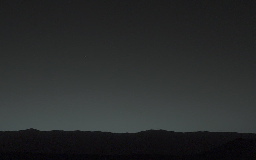

This view of the twilight sky and Martian horizon taken by NASA's Curiosity Mars rover includes Earth as the brightest point of light in the night sky. Earth is a little left of center in the image, and our moon is just below Earth. Two annotated versions of this image are also available in Figures 1 and 2.
Researchers used the left eye camera of Curiosity's Mast Camera (Mastcam) to capture this scene about 80 minutes after sunset on the 529th Martian day, or sol, of the rover's work on Mars (Jan. 31, 2014). The image has been processed to remove effects of cosmic rays. A human observer with normal vision, if standing on Mars, could easily see Earth and the moon as two distinct, bright "evening stars." The distance between Earth and Mars when Curiosity took the photo was about 99 million miles (160 million kilometers).
NASA's Jet Propulsion Laboratory, a division of the California Institute of Technology, Pasadena, manages the Mars Science Laboratory Project for NASA's Science Mission Directorate, Washington. JPL designed and built the project's Curiosity rover. Malin Space Science Systems, San Diego, built and operates the rover's Mastcam.
More information about Curiosity is online at http://www.nasa.gov/msl and http://mars.jpl.nasa.gov/ms

This image combines information from three separate exposures taken by Mastcam's right-eye camera, which has a telephoto lens. The body in the upper half of the image is Earth, shining brighter than any star in the Martian night sky. In the lower half of the image is Earth's moon, with its brightness enhanced to aid visibility. To a viewer on Mars, even the moon would appear as bright as a very bright star.
NASA spacecraft that have previously returned images of Earth taken from Mars orbit or from the surface of Mars include Mars Global Surveyor in 2003 (http://photojournal.jpl.nasa.gov/catalog/PIA04531), Mars Exploration Rover Spirit in 2004 (http://photojournal.jpl.nasa.gov/catalog/PIA05560) and Mars Reconnaissance Orbiter in 2007 (http://photojournal.jpl.nasa.gov/catalog/PIA10244). NASA's Jet Propulsion Laboratory, a division of the California Institute of Technology, Pasadena, manages the Mars Science Laboratory Project for NASA's Science Mission Directorate, Washington. JPL designed and built the project's Curiosity rover. Malin Space Science Systems, San Diego, built and operates the rover's Mastcam.

This scene looking back at where Curiosity crossed a dune at "Dingo Gap" combines several exposures taken by the Navigation Camera (Navcam) high on the rover's mast. The panorama is centered toward the east and spans about 225 degrees, from north-northwest at the left to west-southwest at the right. For scale, the distance between Curiosity's parallel wheel tracks is about 9 feet (2.7 meters). The panorama is presented here as a cylindrical projection. The component images were taken during the 539th Martian day, or sol, of the rover's work on Mars (Feb. 10, 2014) from a location reached by a drive the preceding sol. Curiosity crossed the dune at Dingo Gap, near the middle of the horizon of this scene, on Sol 535 (Feb. 6, 2014). The dune is about 3 feet (1 meter) tall. The high-mounted cylinder on the rear part of the vehicle is the rover's UHF (ultrahigh frequency) antenna. The set of disks mounted below it is part of the calibration target for Curiosity's Chemistry and Camera (ChemCam) instrument. The ball-on-a-stick device in the foreground is the calibration target, including a sundial, for Curiosity's Mast Camera (Mastcam). To the right of the UHF antenna in this image are the radiator fins for Curiosity's power supply, a radioisotope thermoelectric generator. NASA's Jet Propulsion Laboratory, a division of the California Institute of Technology, Pasadena, manages the Mars Science Laboratory Project for NASA's Science Mission Directorate, Washington. JPL designed and built the project's Curiosity rover and the rover's Navcam. 
The hole that NASA's Curiosity Mars rover drilled into target rock "John Klein" provided a view into the interior of the rock, as well as obtaining a sample of powdered material from the rock. The rock is part of the Sheepbed mudstone deposit in the Yellowknife Bay area of Gale Crater. This image, taken by Curiosity's Mars Hand Lens Imager (MAHLI) camera, reveals gray colored cuttings, rock powder and interior wall. Notice the homogeneous, fine grain size of the mudstone, and the irregular network of sulfate-filled hairline fractures. A vertical array of pits in the side of the hole resulted from using the laser-shooting Chemistry and Camera (ChemCam) instrument to assess composition at those points. The MAHLI took this image during the 270th Martian day, or sol, of Curiosity's work on Mars (May 10, 2013). The diameter of hole is about 0.6 inch (1.6 centimeters). The Sheepbed mudstone is interpreted to represent an ancient lake. It preserves evidence of an environment that would have been suited to support microbes that get their energy by eating chemicals in rocks. This wet environment was characterized by neutral pH, low salinity, and variable oxidation of iron- and sulfur-containing minerals. Carbon, hydrogen, oxygen, sulfur, nitrogen and phosphorus were measured directly as key elements for supporting possible life. These results highlight the biological viability of fluvial-lacustrine environments (streams and lakes) in the history of Mars after the earliest era of the Martian past, called the Noachian Era. Image credit: NASA/JPL-Caltech/MSSS


