Skip to comments.
Mars Curiosity - Latest Images
NASA/JPL ^
| 8/7/2012
| http://www.nasa.gov/mission_pages/msl/multimedia/PIA15986.html
Posted on 08/07/2012 10:38:08 AM PDT by dragnet2
click here to read article
Navigation: use the links below to view more comments.
first previous 1-20, 21-40, 41-60, 61-80, 81-96 last

Curiosity's First Arm Extension, Full Resolution
The extended robotic arm of NASA's Mars rover Curiosity can be seen in this mosaic of full-resolution images from Curiosity's Navigation camera (Navcam). Curiosity extended its arm on Aug. 20, 2012.
The 7-foot-long (2.1-meter-long) arm maneuvers a turret of tools including a camera, a drill, a spectrometer, a scoop and mechanisms for sieving and portioning samples of powdered rock and soil.
This mosaic is made using three images projected in a perspective view, which means the images are combined to appear as if they were taken from a single, larger camera.
Curiosity landed on Mars on Aug. 5 PDT (Aug. 6 EDT) to begin its two-year mission, using 10 instruments to assess whether a carefully chosen study area inside Gale Crater has ever offered environmental conditions favorable for microbial life. The Jet Propulsion Laboratory, a division of the California Institute of Technology, Pasadena, manages the Mars Science Laboratory Project, including Curiosity, for NASA's Science Mission Directorate, Washington. JPL designed and built the rover. The Space Division of MDA Information Systems Inc. built the robotic arm in Pasadena.
Image Credit: NASA/JPL-Caltech
81
posted on
08/22/2012 11:11:12 PM PDT
by
dragnet2
(Diversion and evasion are tools of deceit)

The Promised Land
This image (cut out from a mosaic) shows the view from the landing site of NASA's Curiosity rover toward the lower reaches of Mount Sharp, where Curiosity is likely to begin its ascent through hundreds of feet (meters) of layered deposits. The lower several hundred feet (meters) show evidence of bearing hydrated minerals, based on orbiter observations. The terrain Curiosity will explore is marked by hills, buttes, mesas and canyons on the scale of one-to-three story buildings, very much like the Four Corners region of the western United States.
A scale bar indicates a distance of 1.2 miles (2 kilometers).
Curiosity's 34-millimeter Mast Camera acquired this high-resolution image on Aug. 8, 2012 PDT (Aug. 9 EDT).
This image shows the colors modified as if the scene were transported to Earth and illuminated by terrestrial sunlight. This processing, called "white balancing," is useful to scientists for recognizing and distinguishing rocks by color in more familiar lighting.
Mars Science Laboratory is a project of NASA's Science Mission Directorate. The mission is managed by JPL. Curiosity was designed, developed and assembled at JPL, a division of the California Institute of Technology in Pasadena.
82
posted on
08/22/2012 11:26:04 PM PDT
by
dragnet2
(Diversion and evasion are tools of deceit)
Full-Res JPG:
Layers at the Base of Mount Sharp
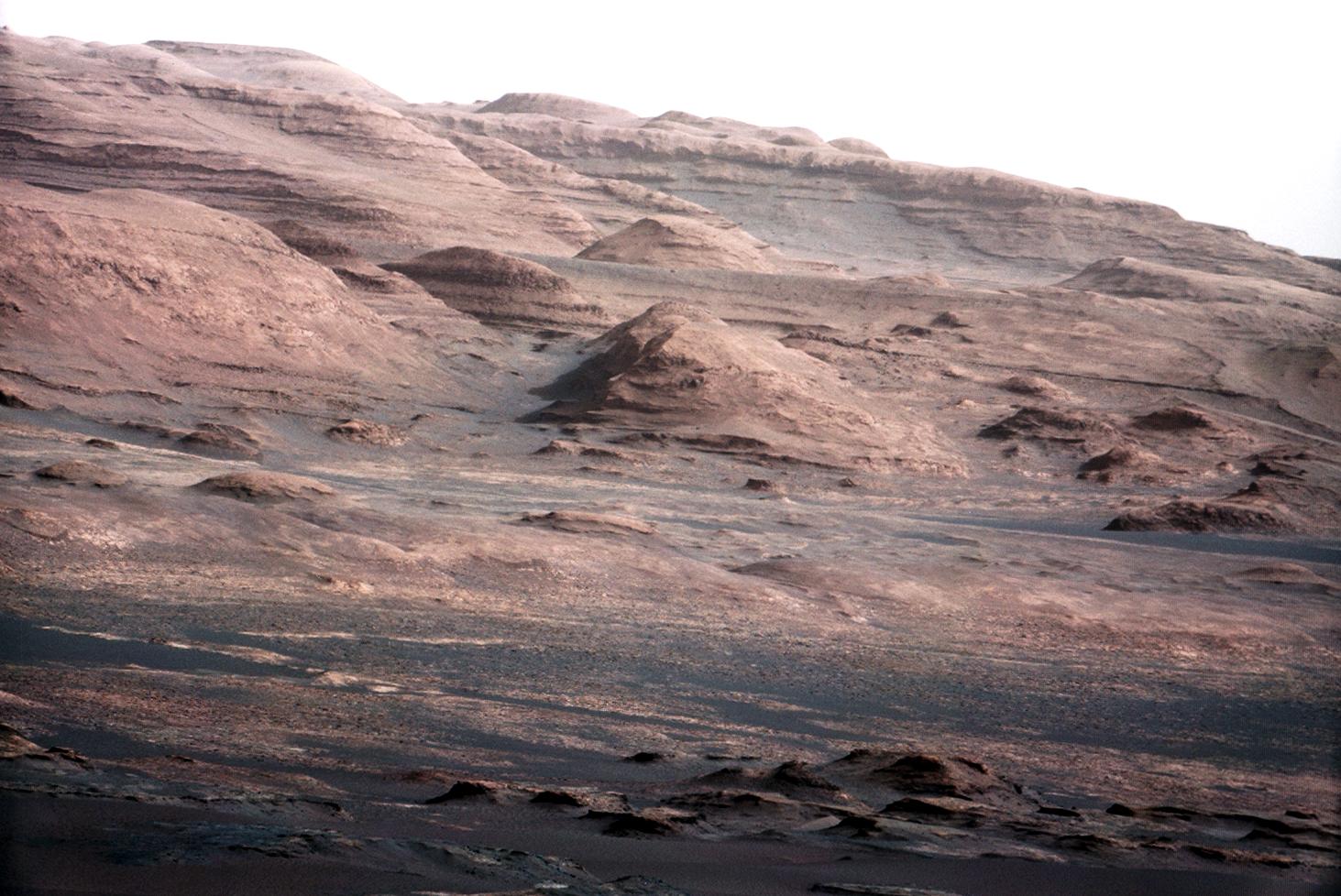
A chapter of the layered geological history of Mars is laid bare in this postcard from NASA's Curiosity rover. The image shows the base of Mount Sharp, the rover's eventual science destination.
This image is a portion of a larger image taken by Curiosity's 100-millimeter Mast Camera on Aug. 23, 2012. See PIA16104. Scientists enhanced the color in one version to show the Martian scene under the lighting conditions we have on Earth, which helps in analyzing the terrain.
For scale, an annotated version of the figure highlights a dark rock that is approximately the same size as Curiosity. The pointy mound in the center of the image, looming above the rover-sized rock, is about 1,000 feet (300 meters) across and 300 feet (100 meters) high.
83
posted on
08/27/2012 4:42:11 PM PDT
by
dragnet2
(Diversion and evasion are tools of deceit)

Landing Site Panorama, with the Heights of Mount Sharp
This color panorama shows a 360-degree view of the landing site of NASA's Curiosity rover, including the highest part of Mount Sharp visible to the rover. That part of Mount Sharp is approximately 12 miles (20 kilometers) away from the rover.
The images were obtained by the rover's 34-millimeter Mast Camera. The mosaic, which stretches about 29,000 pixels across by 7,000 pixels high, includes 130 images taken on Aug. 8 and an additional 10 images taken on Aug. 198. These images were shot before the camera was fully characterized.
Scientists enhanced the color in one version to show the Martian scene as it would appear under the lighting conditions we have on Earth, which helps in analyzing the terrain. A raw version is also available.
Image credit: NASA/JPL-Caltech/MSSS
84
posted on
08/27/2012 6:21:42 PM PDT
by
dragnet2
(Diversion and evasion are tools of deceit)

Focusing the 34-millimeter Mastcam
This image is from a series of test images to calibrate the 34-millimeter Mast Camera on NASA's Curiosity rover. It was taken on Aug. 23, 2012 and looks south-southwest from the rover's landing site.
The gravelly area around Curiosity's landing site is visible in the foreground. Farther away, about a third of the way up from the bottom of the image, the terrain falls off into a depression (a swale). Beyond the swale, in the middle of the image, is the boulder-strewn, red-brown rim of a moderately-sized impact crater. Father off in the distance, there are dark dunes and then the layered rock at the base of Mount Sharp. Some haze obscures the view, but the top ridge, depicted in this image, is 10 miles (16.2 kilometers) away.
Scientists enhanced the color in one version to show the Martian scene under the lighting conditions we have on Earth, which helps in analyzing the terrain. A raw version is also available.
The 34-millimeter Mastcam takes images with lower resolution, but a much wider field of view than the 100-millimeter Mastcam. A sharper version of the same scene from the telephoto 100-millimeter Mastcam can be seen at PIA16104.
Image credit: NASA/JPL-Caltech/MSSS
85
posted on
08/27/2012 6:26:16 PM PDT
by
dragnet2
(Diversion and evasion are tools of deceit)

Focusing the 100-millimeter Mastcam
This image is from a test series used to characterize the 100-millimeter Mast Camera on NASA's Curiosity rover. It was taken on Aug. 23, 2012, and looks south-southwest from the rover's landing site.
The 100-millimeter Mastcam has three times better resolution than Curiosity's 34-millimeter Mastcam, though it has a narrower field of view. For comparison, see PIA16103.
The gravelly area around Curiosity's landing site is visible in the foreground. Farther away, about a third of the way up from the bottom of the image, the terrain falls off into a depression (a swale). Beyond the swale, in the middle of the image, is the boulder-strewn, red-brown rim of a moderately-sized impact crater. Farther off in the distance, there are dark dunes and then the layered rock at the base of Mount Sharp. Some haze obscures the view, but the top ridge, depicted in this image, is 10 miles (16.2 kilometers) away.
Scientists enhanced the color in one version to show the Martian scene under the lighting conditions we have on Earth, which helps in analyzing the terrain. A raw version is also available.
An annotated version of the image indicates the distances to different features. They were calculated using a computer program that analyzes data from the High Resolution Imaging Science Experiment (HiRISE) camera aboard NASA's Mars Reconnaissance Orbiter.
Image credit: NASA/JPL-Caltech/MSSS
86
posted on
08/27/2012 6:31:45 PM PDT
by
dragnet2
(Diversion and evasion are tools of deceit)
To: dragnet2
Thanks for posting these great pics. Really amazing.
To: Yardstick
Yes, they are.
And feel free to post any images you come across!
BTW, I find myself just staring at these image and have to remind myself, this isn’t earth and the images are being sent from about 63 million miles from home.
88
posted on
08/27/2012 6:39:27 PM PDT
by
dragnet2
(Diversion and evasion are tools of deceit)
To: Yardstick

Looking Back at Tracks from Sol 24 Drive
NASA's Mars rover Curiosity drove about 70 feet (about 21 meters) on the mission's 21st Martian day, or sol (Aug. 30, 2012) and then took images with its Navigation Camera that are combined into this scene, which inclues the fresh tracks. The view is centered toward the west-northwest.
Image credit: NASA/JPL-Caltech
89
posted on
09/01/2012 7:40:37 PM PDT
by
dragnet2
(Diversion and evasion are tools of deceit)

Portrait of APXS on Mars
This image shows the Alpha Particle X-Ray Spectrometer (APXS) on NASA's Curiosity rover, with the Martian landscape in the background. The image was taken by Curiosity's Mast Camera on the 32nd Martian day, or sol, of operations on the surface (Sept. 7, 2012, PDT or Sept. 8, 2012, UTC). APXS can be seen in the middle of the picture.
This image let researchers know that the APXS instrument had not become caked with dust during Curiosity's dusty landing.
Scientists enhanced the color in this version to show the Martian scene as it would appear under the lighting conditions we have on Earth, which helps in analyzing the terrain.
Image credit: NASA/JPL-Caltech/MSSS
90
posted on
09/14/2012 8:09:36 PM PDT
by
dragnet2
(Diversion and evasion are tools of deceit)

Curiosity Traverse Map Through Sol 43
This map shows the route driven by NASA's Mars rover Curiosity through the 43rd Martian day, or sol, of the rover's mission on Mars (Sept. 19, 2012).
The route starts where the rover touched down, a site subsequently named Bradbury Landing. The line extending toward the right (eastward) from Bradbury Landing is the rover's path. Numbering of the dots along the line indicate the distance driven each sol. North is up. The scale bar is 200 meters (656 feet).
By Sol 43, Curiosity had driven at total of about 950 feet (290 meters). The Glenelg area farther east is the mission's first major science destination, selected as likely to offer a good target for Curiosity's first analysis of powder collected by drilling into a rock.
The image used for the map is from an observation of the landing site by the High Resolution Imaging Science Experiment (HiRISE) instrument on NASA's Mars Reconnaissance Orbiter.
Image credit: NASA/JPL-Caltech/Univ. of Arizona
91
posted on
09/20/2012 11:20:00 AM PDT
by
dragnet2
(Diversion and evasion are tools of deceit)
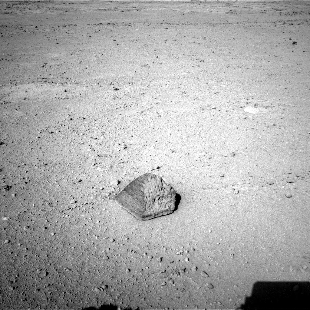
'Jake Matijevic' Contact Target for Curiosity
The drive by NASA's Mars rover Curiosity during the mission's 43rd Martian day, or sol, (Sept. 19, 2012) ended with this rock about 8 feet (2.5 meters) in front of the rover. The rock is about 10 inches (25 centimeters) tall and 16 inches (40 centimeters) wide. The rover team has assessed it as a suitable target for the first use of Curiosity's contact instruments on a rock. The image was taken by the left Navigation camera (Navcam) at the end of the drive.
The rock has been named "Jake Matijevic." This commemorates Jacob Matijevic (1947-2012), who was the surface operations systems chief engineer for the Mars Science Laboratory Project and the project's Curiosity rover. He was also a leading engineer for all of the previous NASA Mars rovers: Sojourner, Spirit and Opportunity.
Curiosity's contact instruments are on a turret at the end of the rover's arm. They are the Alpha Particle X-Ray Spectrometer for reading a target's elemental composition and the Mars Hand Lens Imager for close-up imaging.
92
posted on
09/20/2012 11:26:07 AM PDT
by
dragnet2
(Diversion and evasion are tools of deceit)
To: All

Remnants of Ancient Streambed on Mars
NASA's Curiosity rover found evidence for an ancient, flowing stream on Mars at a few sites, including the rock outcrop pictured here, which the science team has named "Hottah" after Hottah Lake in Canada’s Northwest Territories. It may look like a broken sidewalk, but this geological feature on Mars is actually exposed bedrock made up of smaller fragments cemented together, or what geologists call a sedimentary conglomerate. Scientists theorize that the bedrock was disrupted in the past, giving it the titled angle, most likely via impacts from meteorites.
The key evidence for the ancient stream comes from the size and rounded shape of the gravel in and around the bedrock. Hottah has pieces of gravel embedded in it, called clasts, up to a couple inches (few centimeters) in size and located within a matrix of sand-sized material. Some of the clasts are round in shape, leading the science team to conclude they were transported by a vigorous flow of water. The grains are too large to have been moved by wind.
A close-up view of Hottah reveals more details of the outcrop. Broken surfaces of the outcrop have rounded, gravel clasts, such as the one circled in white, which is about 1.2 inches (3 centimeters) across. Erosion of the outcrop results in gravel clasts that protrude from the outcrop and ultimately fall onto the ground, creating the gravel pile at left.
This image mosaic was taken by Curiosity's 100-millimeter Mastcam telephoto lens on its 39th Martian day, or sol, of the mission (Sept. 14, 2012 PDT/Sept. 15 GMT).
Image credit: NASA/JPL-Caltech/MSSS
93
posted on
09/27/2012 1:48:16 PM PDT
by
dragnet2
(Diversion and evasion are tools of deceit)
To: dragnet2

This scene combines images taken by the left-eye camera of the Mast Camera (Mastcam) instrument on NASA's Curiosity Mars rover during the midafternoon, local Mars solar time, of the mission's 526th Martian day, or sol (Jan. 28, 2014). The sand dune in the upper center of the image spans a gap, called "Dingo Gap," between two short scarps. The dune is about 3 feet (1 meter) high. The nearer edge of it is about 115 feet (35 meters) away from the rover's position when the component images were taken, just after a Sol 526 drive of 49 feet (15 meters).
The image has been white-balanced to show what the rocks would look like if they were on Earth. A version with 200-centimeter (79-inch) scale bars is available as Figure A. A version with raw color, as recorded by the camera under Martian lighting conditions, is available as Figure B.
NASA's Jet Propulsion Laboratory manages the Mars Science Laboratory mission and the mission's Curiosity rover for NASA's Science Mission Directorate in Washington. The rover was designed, developed and assembled at JPL, a division of the California Institute of Technology in Pasadena.
Malin Space Science Systems, San Diego, built and operates Mastcam.
94
posted on
01/31/2014 1:03:58 PM PST
by
dragnet2
(Diversion and evasion are tools of deceit)
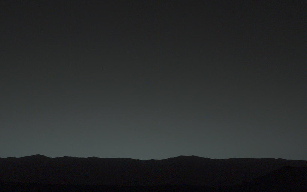

This view of the twilight sky and Martian horizon taken by NASA's Curiosity Mars rover includes Earth as the brightest point of light in the night sky. Earth is a little left of center in the image, and our moon is just below Earth. Two annotated versions of this image are also available in Figures 1 and 2.
Researchers used the left eye camera of Curiosity's Mast Camera (Mastcam) to capture this scene about 80 minutes after sunset on the 529th Martian day, or sol, of the rover's work on Mars (Jan. 31, 2014). The image has been processed to remove effects of cosmic rays. A human observer with normal vision, if standing on Mars, could easily see Earth and the moon as two distinct, bright "evening stars." The distance between Earth and Mars when Curiosity took the photo was about 99 million miles (160 million kilometers).
NASA's Jet Propulsion Laboratory, a division of the California Institute of Technology, Pasadena, manages the Mars Science Laboratory Project for NASA's Science Mission Directorate, Washington. JPL designed and built the project's Curiosity rover. Malin Space Science Systems, San Diego, built and operates the rover's Mastcam.
More information about Curiosity is online at http://www.nasa.gov/msl and http://mars.jpl.nasa.gov/ms

This image combines information from three separate exposures taken by Mastcam's right-eye camera, which has a telephoto lens. The body in the upper half of the image is Earth, shining brighter than any star in the Martian night sky. In the lower half of the image is Earth's moon, with its brightness enhanced to aid visibility. To a viewer on Mars, even the moon would appear as bright as a very bright star.
NASA spacecraft that have previously returned images of Earth taken from Mars orbit or from the surface of Mars include Mars Global Surveyor in 2003 (http://photojournal.jpl.nasa.gov/catalog/PIA04531), Mars Exploration Rover Spirit in 2004 (http://photojournal.jpl.nasa.gov/catalog/PIA05560) and Mars Reconnaissance Orbiter in 2007 (http://photojournal.jpl.nasa.gov/catalog/PIA10244). NASA's Jet Propulsion Laboratory, a division of the California Institute of Technology, Pasadena, manages the Mars Science Laboratory Project for NASA's Science Mission Directorate, Washington. JPL designed and built the project's Curiosity rover. Malin Space Science Systems, San Diego, built and operates the rover's Mastcam.
95
posted on
02/07/2014 9:55:05 PM PST
by
dragnet2
(Diversion and evasion are tools of deceit)
To: All

This scene looking back at where Curiosity crossed a dune at "Dingo Gap" combines several exposures taken by the Navigation Camera (Navcam) high on the rover's mast. The panorama is centered toward the east and spans about 225 degrees, from north-northwest at the left to west-southwest at the right. For scale, the distance between Curiosity's parallel wheel tracks is about 9 feet (2.7 meters). The panorama is presented here as a cylindrical projection. The component images were taken during the 539th Martian day, or sol, of the rover's work on Mars (Feb. 10, 2014) from a location reached by a drive the preceding sol. Curiosity crossed the dune at Dingo Gap, near the middle of the horizon of this scene, on Sol 535 (Feb. 6, 2014). The dune is about 3 feet (1 meter) tall. The high-mounted cylinder on the rear part of the vehicle is the rover's UHF (ultrahigh frequency) antenna. The set of disks mounted below it is part of the calibration target for Curiosity's Chemistry and Camera (ChemCam) instrument. The ball-on-a-stick device in the foreground is the calibration target, including a sundial, for Curiosity's Mast Camera (Mastcam). To the right of the UHF antenna in this image are the radiator fins for Curiosity's power supply, a radioisotope thermoelectric generator. NASA's Jet Propulsion Laboratory, a division of the California Institute of Technology, Pasadena, manages the Mars Science Laboratory Project for NASA's Science Mission Directorate, Washington. JPL designed and built the project's Curiosity rover and the rover's Navcam. 
The hole that NASA's Curiosity Mars rover drilled into target rock "John Klein" provided a view into the interior of the rock, as well as obtaining a sample of powdered material from the rock. The rock is part of the Sheepbed mudstone deposit in the Yellowknife Bay area of Gale Crater. This image, taken by Curiosity's Mars Hand Lens Imager (MAHLI) camera, reveals gray colored cuttings, rock powder and interior wall. Notice the homogeneous, fine grain size of the mudstone, and the irregular network of sulfate-filled hairline fractures. A vertical array of pits in the side of the hole resulted from using the laser-shooting Chemistry and Camera (ChemCam) instrument to assess composition at those points. The MAHLI took this image during the 270th Martian day, or sol, of Curiosity's work on Mars (May 10, 2013). The diameter of hole is about 0.6 inch (1.6 centimeters). The Sheepbed mudstone is interpreted to represent an ancient lake. It preserves evidence of an environment that would have been suited to support microbes that get their energy by eating chemicals in rocks. This wet environment was characterized by neutral pH, low salinity, and variable oxidation of iron- and sulfur-containing minerals. Carbon, hydrogen, oxygen, sulfur, nitrogen and phosphorus were measured directly as key elements for supporting possible life. These results highlight the biological viability of fluvial-lacustrine environments (streams and lakes) in the history of Mars after the earliest era of the Martian past, called the Noachian Era. Image credit: NASA/JPL-Caltech/MSSS
96
posted on
03/12/2014 4:30:56 PM PDT
by
dragnet2
(Diversion and evasion are tools of deceit)
Navigation: use the links below to view more comments.
first previous 1-20, 21-40, 41-60, 61-80, 81-96 last
Disclaimer:
Opinions posted on Free Republic are those of the individual
posters and do not necessarily represent the opinion of Free Republic or its
management. All materials posted herein are protected by copyright law and the
exemption for fair use of copyrighted works.
FreeRepublic.com is powered by software copyright 2000-2008 John Robinson