Posted on 04/13/2012 3:20:25 AM PDT by dirtboy
Edited on 04/14/2012 10:35:01 AM PDT by Admin Moderator. [history]
The Storm Prediction Center has predicted a slight chance of severe weather for parts of Texas and Oklahoma this entire week, thus it should come as no surprise that the weekend holds the best chance of dangerous severe weather.
The Storm Prediction Center has issued an upgraded, high chance of severe weather from central Oklahoma through eastern Kansas (see image below). In addition, there is a moderate risk of severe weather from western Texas through southern Iowa, and a slight risk in the greater area from central Texas through southern Wisconsin.
I cannot stress the severity of this situation enough. Residents living in these regions should prepare for severe weather on Saturday.

Thank you for the great posts DB! I'm in western Oklahoma and looking to my North and East I can see huge supercell Mammatus clouds.......I think most of the activity today will be East of me, but I have my storm cellar door unlocked and ready. Pleasr keep the posts coming...thanks.
Interesting the SPC has included a MDT area for tomorrow in WI.
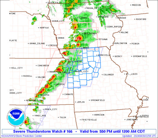
PDS watch just issued for SE Nebraska.

Good info. Scary, but good.
First tornado warning of the day issued:
The National Weather Service in Hastings has issued a
* Tornado Warning for...
western Jewell County in north central Kansas...
northwestern Mitchell County in north central Kansas...
northeastern Osborne County in north central Kansas...
southeastern Smith County in north central Kansas...
* until 1245 PM CDT
* at 1204 PM CDT... National Weather Service Doppler radar indicated a
severe thunderstorm capable of producing a tornado. This dangerous
storm was located 5 miles south of Osborne... or 30 miles west of
Beloit... and moving northeast at 45 mph.
* Locations impacted include...
Downs... Cawker City... Ionia... Esbon... Burr Oak and Mankato.
Thanks for the thread. Greatly appreciated.
Here we go! Lord, please...
That didn’t take long.
Significant Tornado Parameters are expected to be near 25 this evening. This is the highest values we have seen since April 27 when there was a value of 37.

Hmmm...I think maybe I’ll go check out the supplies in the basement...could get wild and wooly up our way later in the day.
Just got in from getting all of my patio furniture and outdoor stuff secured. I do have a man cave and am heading down there to get that prepared. Hoping all of this stuff they are talking about misses us.
My wife has to lector at 5pm mass. Dont wanna leave my dogs alone but its only for an hour.

Check out the dew point map in post 30 and how much the dew points have juiced up in Oklahoma since I posted it.
Wow.
Growing fast, too.
I’m up in Minneapolis-St Paul. We’re on the far northern fringe of getting any sever weather. I can feel a large uptick in the dewpoint from last night.
I can only imagine what it feels like down in the targets area of kansas and Nebraska.
Not only does that mean more juice for thunderstorm development, but also strong southerly winds at the surface for the jet stream to ride over and create rotation.
Disclaimer: Opinions posted on Free Republic are those of the individual posters and do not necessarily represent the opinion of Free Republic or its management. All materials posted herein are protected by copyright law and the exemption for fair use of copyrighted works.