To: melancholy; thackney; Candor7; Cheburashka; org.whodat; Berlin_Freeper; Hotlanta Mike; ...

It is important to read the 1867 treaty between the United States and Russia, because it is very specific about what territory is (and is not) ceded from Russia to the United States. Popular misimpressions abound.
1. The word "Alaska" does not appear anywhere in the treaty. The United States did not buy "Alaska" from Russia. The term "Alaska" at the time referred to a peninsula at the eastern end of the Aleutian Islands.
2. The part of the treaty that explains what is being ceded is Article I: "His Majesty the Emperor of all the Russias agrees to cede to the United States...all the territory and dominion now possessed by his said Majesty on the continent of America and in the adjacent islands, the same being contained within the geographical limits set forth...." In 1867 Russia possessed very little actual land territory on the American continent, consisting mostly of some coastal and river settlements with about 500 inhabitants. The Russians had not even landed on the Arctic Ocean side of modern-day Alaska. The land that the Russians ceded constitutes only a small part of the land mass that is now known as the State of Alaska. Upon taking over the limited Russian lands in 1867, the United States government expanded its domain greatly by exploration, possession, and annexation of huge areas on the mainland, in the Bering Sea, and in the Arctic Ocean, including several islands.
3. The last clause of Article I states, "...to the meridian of one hundred and ninety-three degrees west longitude [167 degrees east], so as to include in the territory conveyed the whole of the Aleutian islands east of that meridian." The westernmost islands in the Aleutian islands are Bering and Copper (with Sea Lion Rock and Sea Otter Rock nearby Copper). This clause was added in the last phase of negotiations to allow Russia to keep Bering Island. The meridian of 193 degrees west (167 degrees east) runs directly between Bering and Copper Islands.

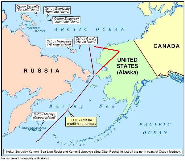
 This maritime boundary line places on the Russian side 8 American Alaskan islands along with their 200-mile seabeds. It amounts to a giveaway of not only the land territory, but also hundreds of thousands of square miles of seabeds to the Russians. (See shaded area of map.) There is no quid pro quo for the American public or the State of Alaska. These seabeds are rich in oil, gas, fisheries, and other resources worth billions of dollars. The oil and gas potential is measured in the billions of barrels. The fisheries are in the hundreds of millions of pounds per year, reflecting that Alaska is the number one fishing state in the nation. The military strategic locations of the Arctic and Bering areas is obvious. Any missiles that might fly toward North America from the Asian mainland would fly over these areas of Alaska, and these islands would be useful for intelligence collection and strategic defense initiative (SDI) installations.
43 posted on
03/16/2012 6:11:35 PM PDT by
Brown Deer
(Pray for 0bama. Psalm 109:8)
To: Brown Deer
were is the Senate and House standing up to him on this
45 posted on
03/16/2012 6:16:14 PM PDT by
blueyon
(The U. S. Constitution - read it and weep)
To: Brown Deer
Thanks, Brown Deer. Very interesting. Although if those earlier posts are true, it looks as if the effort to give away the islands started under George H. W. Bush.
Still, unless the revised treaty proposed back then by Bush has been ratified, it’s still Obama who appears to be doing the giveaway, without due ratification by the Senate. A treaty is not a treaty until it is ratified.
Is that right?
46 posted on
03/16/2012 6:23:04 PM PDT by
Cicero
(Marcus Tullius)
To: Brown Deer; Cicero; Candor7
Your map was not part of the treaty.
http://memory.loc.gov/cgi-bin/ampage?collId=llsl&fileName=015/llsl015.db&recNum=574
It does not match the description of text, including Western southern boundary midway between Attou Island and Copper Island of the Kormandorski couplet.
How does the treaty show Copper Island to be in the US when the treaty clearly drew the line midway between Copper and Attou?
The same happens at the North. Read the text of what you posted. It is true. But the map is something made up.
48 posted on
03/16/2012 7:00:12 PM PDT by
thackney
(life is fragile, handle with prayer)
To: Brown Deer; Candor7; melancholy
.
Thanks, y’all. ... Appreciate the pings.
.
52 posted on
03/16/2012 10:54:26 PM PDT by
LucyT
To: Brown Deer
Obama State Department set to cede oil-rich Alaska islands to Russia... I'm sooooooooooo surprised. /s
55 posted on
03/17/2012 8:21:50 AM PDT by
GOPJ
(Democrat-Media Complex - buried stories and distorted facts... freeper 'andrew' Breitbart)
To: Brown Deer
I don't know what to say to you. You claim the map I posted from the state department is wrong, and the boundary described in the treaty is wrong.
As further proof, you post a link to the same text as the treaty, and a map matching what I posted.
What islands do you believe lie east and west of 193 degrees?
193 is not the dividing line, it is a crossing point on that angled line.
The western boundary of the treaty is defined as the midpoint between Krusenstern and Ratmanoff on the 65 degrees, thirty minutes north latitude. From this point is heads straight north.
Leaving the claimed islands Bennett, Henrietta, Jeannette, Wrangel and Herald on the Russian side of the border.
Then we go back to the same starting point and head southwest, between St. Lawrence and the southeast point of Cape Choukotski, then continue southwest to pass midway between the island of Attou and Copper island.
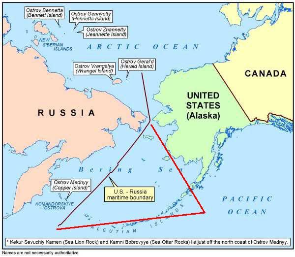
Since the border is east of Copper island, Copper island is in Russia.
None of these island were ever in the US. Can we stop this nonsense now?
68 posted on
03/18/2012 3:28:32 PM PDT by
thackney
(life is fragile, handle with prayer)
FreeRepublic.com is powered by software copyright 2000-2008 John Robinson