At this point, I was thoroughly convinced that the contrail was nothing more than UPS flight 902, back-lit by the setting sun. The object remained in view to the eyewitnesses far too long to have represented a missile launch, despite several credible military experts who had stated the contrary. Because WND was following the lead of these experts, and continued to insist the contrail was a missile exhaust plume, I knew I had to be extremely diplomatic in presenting a countering view, if I wanted them to actually publish it. So I used terminology that was deliberately non-committal.
Furthermore, Gil Leyvas had given freely of his time in presenting his side of the debate, and was very kind and gracious during our phone interview as well as multiple subsequent email exchanges, so I wanted him to have "his day in court." I gave him a lot of column space to explain his perspective.
Here is the article, as I submitted it to WND, with the graphics I recommended (the first of which was graciously supplied by FreeRepublic.com poster TXnMA) and for which I had obtained permission. I was not blatantly militating for the airliner contrail argument, because WND would not have published such an article, but any objective reader would see from the manner in which I presented the facts that, despite Leyvas' good faith, the evidence underpinning the "missile exhaust plume" side of the debate was exceedingly weak at best:
California contrail: Four conflicting eyewitness reports
One month after the KCBS video purporting to show a missile contrail off the coast of California went viral, a heated debate over what exactly created the contrail persists. Experts have offered convincing analysis supporting the theory that the contrail represents an SLBM launch, while internet pundits have assembled a formidable collection of evidence that the contrail was created by UPS flight 902. The debate is seemingly at an impasse, and it might be a good time to step back from the intense data analysis and review the basic facts of November 8, 2010.There are two known eyewitnesses who captured images of the contrail. Gil Leyvas is the helicopter camera man for KCBS in Los Angeles who videotaped the contrail and Rick Warren lives on Long Beach and photographed the contrail from his tenth story balcony. A 50 minute phone interview with Leyvas was obtained for this report and discussed further via email, and Warren was also contacted by email.
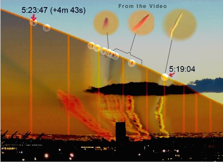
According to Leyvas, his video was obtained while filming a sunset view for a KCBS weather report. As he was filming, Leyvas noticed an object on the horizon that appeared to be climbing vertically out of the ocean, and he zoomed in on the object. He videotaped the contrail for a total of ten minutes and subsequently continued to view the contrail for an additional ten minutes. Leyvas maintains that the object itself that created the contrail only remained in view for two to three minutes. For 30 to 45 seconds, the object glowed brightly and then seemed to disappear from view. His initial impression was that the object was traveling east towards the coast. On reviewing the video later, he had the impression the object may instead have been heading away from the coast, towards the northwest.
The highly unusual appearance of the sunset contrail shown on TV and posted online, combined with Leyvas’ perception that the object creating the contrail only remained in view for two to three minutes, constitutes the primary basis upon which many observers believe the object was a Sub Launched Ballistic Missile.
Rick Warren wasn’t sure what the object was that he was photographing on November 8th. “I was shooting with a telephoto lens and looking through a viewfinder so I never really saw the separation of the object and the contrail until I looked at the photos, but I’m sure that this whole thing lasted way too long to be a missile. I see lots of contrails from my 10th floor balcony but the difference in this one was that it “seemed” to be going up.”
Having seen many contrails, what stood out for Warren was the vertical nature of the contrail, not that it looked like a missile exhaust plume. Some of his photos of the contrail were posted on the local ABC7 website, and were utilized by Mick West of Contrailscience.com to create a composite image of the flight progression of the object. The time stamps on Warren’s photos were used to establish that the object creating the contrail remained in view for 4 minutes 43 seconds in Warren’s photos. Based on altitude and position, the object first appeared in Leyvas’ video at least five minutes prior to Warren’s photos. After seeing West’s analysis of the images, Warren says, “I’m now of the opinion that it was indeed a plane."
At this point, one of the most glaring discrepancies between these eyewitness accounts must be addressed. Most observers looking at Warren’s images agree that the small dark object which appears at the top of each of his later photos is the same craft creating the plume that was seen in his earlier photos as well as that which was seen in Leyvas’ video.
If the object that created the contrail was still visible in Warren’s photos, then the object itself is not likely to have been a missile. Solid fuel engines such as those used in an SLBM create an uninterrupted exhaust plume for two to three minutes, after which time the solid fuel is spent, and the missile is usually out of view.
On the other hand, when an airliner transitions from cold moist air to warmer drier air, the dew point changes and contrail formation decreases. In the case of USP902, the airliner would have been transitioning from moist cool air at altitude over the ocean to warmer, drier air over land. This could explain the contrail disappearing as the object moved farther east.
Mick West created a "chronological cut" of Leyvas’ video and posted it to YouTube. The transition from moist cool air over the ocean to warmer, drier air over land may have occurred at 1:17 to 1:20 of the chronological cut, which Warren referred to as “the separation of the object and the contrail.” When still images from Leyvas’ video are compared to the overlay of Warren’s photos, there is a remarkable similarity and continuity between the two sets of images, providing a better time frame for Leyvas’ video within the context of Warren’s time stamps:
When Leyvas was initially queried regarding these later photos, he replied,
“…the [Contrailscience composite] animation … only shows the path the plume drifted and not anything in flight. The 30-45 seconds of video I captured in which I could see the object (the portion of the video showing the glow/flame of the object at its pinnacle) occurred 8-10 minutes prior to the animated images of the animation (if the time stamps are accurate). I have no way of telling if those time stamps are accurate since the raw video has no real-time time stamp associated with it. I can only go by an estimated time based on the time we launched out of John Wayne airport and the approximate time of our weather shot. My guess is that the time stamps are relatively close to the accurate time. However, what you are seeing in those images is the plume drifting and not anything in flight.
Leyvas still maintains the object creating the contrail is not visible in Warren’s photos 8 to 10 minutes later:
”The separate smaller trail that is separate from the main body of the plume and that was captured by Warren in his photos, which makes it seem as if the object continued in flight, appears in my video to possibly be the top portion of the plume that partly dissipates leaving a segment of the tip adrift - detached from the main body of the plume. (I highlight "possibly be" because during that portion of the video, I zoom in and out and pan off and back onto the plume, so I'm not sure if what we are seeing is a stage of separation like that of a missile or if it's the tip of the plume separating from the main portion). I did zoom into that portion to see if I could see a craft of some kind (at the time I thought that there was a chance the object was still making condensation/exhaust) but there was nothing there creating that segment. Had there been, I know I would have been able to see it with the high-powered lens I was using. Add to that - if it was traveling toward us, the closer it would come the easier it would be to see it, but there was nothing there. That's why I said it was merely the plume adrift and not anything continuously flying.
“Though there was no time code associated with the raw footage I shot, you are still able to accurately time the footage from the moment I started the recording (as we departed John Wayne airport) to the final moments of the mystery missile story. When I play the video I can time the duration of the object in flight which was between 30-45 seconds of "Glow Time" - which is inclusive within, and at the end of the 2-3 minute estimated flight time from which the plume was visible at the horizon ... I can rely on the raw footage as it plays to gauge my estimated times since it plays back in real time on the player deck's control track timer.”
There were also two unknown witnesses who captured images of the contrail, both anonymous posters on the image hosting website Flickr. A photographer on Hermosa Beach, north of Leyvas and Warren, uploaded a photo of the November 8 sunset and only subsequently realized he had captured the same contrail due to media reports. From his vantage point, without the setting sun directly back-lighting the contrail, it apparently appeared similar to the other contrails in his sunset photo.
Another anonymous photographer uploaded photos of clouds at sunset on November 8, and noticed a bright horizontal contrail that he subsequently associated with the media reports regarding the contrail. Notice that in the case of these latter two eyewitnesses, the first noted nothing unusual about the contrail until he read media reports about it, and the second viewed a horizontal, not vertical contrail.
Finally, the opinions of the known military experts must be taken into consideration. Several highly credible experts have stated their opinion that the contrail in question represented the launching of an SLBM.
A little further background from Leyvas might shed more light on the way the video was edited and presented to the public. Leyvas related that the video was taken during sweeps week in his TV market, and part of his job during sweeps week is to go out and look for and capture video of interest for sweeps week ratings. The video he captured of the contrail was subsequently heavily edited before being aired, and less than two minutes of the ten minutes of video has been seen by these experts. From the perspective of garnering sweeps week ratings, the footage was certainly successful.
It may be that the experts would modify their opinion based on viewing the entire footage. The footage is owned by the local CBS affiliate and nothing was found by the Department of Defense in reviewing the footage that would prevent its release to the public. According to Leyvas, it might still be available on their server. If that is the case, it should just be a matter of uploading the unedited ten minutes of video to YouTube to put an end to the debate.

Now compare the article I composed and submitted above to the sensationalistic manipulated (and frankly, fabricated) version WND actually published:
MATTERS OF NATIONAL SECURITY
Mysterious missile launch baffles even eyewitnesses
Video, still photographers watched contrail soaring over Pacific Coast
One thing to note, as I implied in my original closing paragraph. Both CBS and WND know that Gil Leyvas has a back up copy of the original unedited ten minutes of raw footage. CBS knows they duped credible military experts into stating publicly that the contrail was formed by a missile by deliberately editing the raw footage for ratings. CBS has also conveniently let the impression persist from the first week that the video was seized by the Department of Defense for analysis (implying they no longer had a copy.)
WND also knows from my correspondence with them that a back-up copy exists, but they left that important fact out of their version of the story.
Frankly, both media outlets are acting like ... typical mainstream media outlets.
I never trusted CBS to begin with.
Unfortunately, I can no longer trust World Net Daily as a news source.
And I sure as heck will never submit anything to them in the future for publication.

