Nice work on the progression graphic, NN!
Where did you get the "after" images for that?
Extending the linear debris fields out of Gilchrist points a little further east than the yellow dot on your graphic. It would be interesting to see imagery all along that coastline. Is more imagery available?
There's no telling what the surge currents did after they dropped the heavier structural debris that's visible in the Gilchrist overheads. I projected a straight line and that's really an unsupportable extrapolation as local eddies might have altered the flow east, west, north or south, I could even make a case for a U turn as the backside of the storm passed over and the surge began to leave the bay.
Be aware that closer inspection of these overheads could be grisly. At these resolutions, human remains are at the low edge of discernability, but the math doesn't always rule in analyzing overheads. It's actually pretty easy to make out dirt roads and trails on 30 meter per pixel Landsat imagery, when common sense tells you that a dirt trail is nowhere near as wide as the 100 to 180 feet wide that should be necessary to make out the feature.
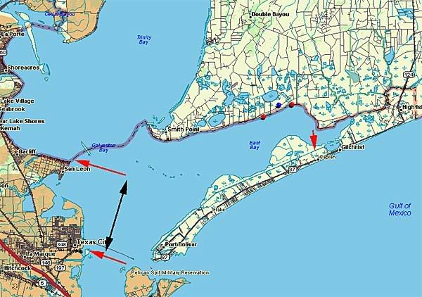
In the image above, the twin red dots mark where linear extension of the Gilchrist debris trails might have come to rest.
The lone blue dot is the position of the East Robinson Lake Gas Field, in my opinion, the most likely source of the oily slick we see in the NOAA overhead imagery.
During storm passage I was worried about the west bay shoreline as indicated by the paired red arrows and black arrow. With Bolivar Peninsula clearly under water from the surge, this area become the de-facto "front line" for surge and wave action, in terms of heavily populated areas.
If nothing else, Bolivar Peninsula fulfilled its reason for existence, in blocking enough surge to prevent catastrophic damage here.
Finally, the lone red arrow indicates additional large debris fields that came to rest on the north side of the canal/waterway along Bolivar Peninsula. Although I think I can resolve individual floor joists, which should be 1.5 inches by 10 to 12 inches by 16 feet or so, I do not find any human remains, even at maximum magnification and processing.
That leads me to raise the possibility that the dynamics of the surge as Ike came ashore may have brought water levels up enough to scare many of the stay-behinds to evacuate through waist deep water, long before the main surge came ashore. We can hope, anyway.
 Note how much sand washed into the Gulf...