Check out the '2' in Wilma's eye.

Posted on 09/01/2007 6:57:00 AM PDT by NautiNurse
I hope they listen and leave.
Check out the '2' in Wilma's eye.
p.s. - A little trivia - Miskito Indians is where the English word Mosquito comes from
http://en.wikipedia.org/wiki/Mosquito_Coast
Figures; I just got chased back inside from a decent fire by a horde of mosquitoes.
I have this picture in my mind of a cat(Felix) swiping at mosquitos around him while coming ashore
c’mon...
Yeah, but SSM/I and TRMM/TMI passive microwave imagery and sounding channel data is indicative this guy’s lame. Entire western quadrant is dry as a bone, virtually no low level inflow feeders, and convection isn’t all that impressive, albeit fairly widespread (approximately covering the area colored green that surrounds the “9”.
While the latest pass only has 73% coverage, the eastern quadrant isn’t looking all that hot either with respect to water vapor.
To me it looks like he’s choking.
Spoken like a true Michigander.
Agree that Felix isn't the monster he was yesterday. That doesn't equate to lame for those of us who have family and friends in the region. Otherwise, a good analysis.
Oh, THAT 2. I thought it was the 2 nm eye that Wilma had at one point.
Can you tell me roughly where.... in those 1200 posts, you discuss the ‘2’ eye? 1st 200, 2nd 200, 3rd 200, etc :)
I need a bigger monitor; didn’t recognize the “radar 2” :-)
Felix’s pressure is down by 3
Wilma also had 2 distinct eyes at one point.
Not seeing the drop; the 8 pm advisory is essentially the same as the 5 pm one right down to the estimated 953 mb pressure, and the next AF Hunter isn’t in the air yet (last one left Felix at about 4:45 pm EDT this afternoon).
Statement as of 8:00 PM EDT on September 03, 2007
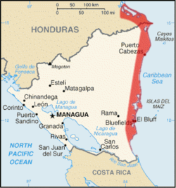
...Extremely dangerous Hurricane Felix approaches northeastern
Nicaragua and eastern Honduras...

A Hurricane Warning is in effect for Nicaragua from Puerto Cabezas
northward to the Honduras/Nicaragua border...and for Honduras from
Limon eastward to the Honduras/Nicaragua border.  A Hurricane
Warning means that hurricane conditions are expected within the
warning area within the next 24 hours.  Preparations to protect
life and property should be rushed to completion.

A Hurricane Watch is in effect for Honduras west of Limon...for the
Caribbean coast of Guatemala...and for the entire coast of Belize.

A Tropical Storm Warning remains in effect for Isla de Providencia.

At 8 PM EDT...0000 UTC...the government of the Cayman Islands has
discontinued the tropical storm watch for Grand Cayman.

For storm information specific to your area...including possible
inland watches and warnings...please monitor products issued
by your local weather office.

At 800 PM EDT...0000z...the center of Hurricane Felix was located
near latitude 14.5 north...longitude 80.2 west or about 205 miles...
325 km...east of Cabo Gracias a Dios on the Nicaragua/Honduras
border.

Felix is moving toward the west near 18 mph...30 km/hr...and this
motion is expected to continue for the next 24 hours.  On this
track...the center of Felix will be near the coasts of extreme
northeastern Nicaragua and eastern Honduras early on Tuesday
morning.

Maximum sustained winds are near 135 mph...215 km/hr...with higher
gusts.  Felix is currently a category four hurricane on the
Saffir-Simpson scale.  Felix is expected to remain a major
hurricane...at least category three...until it makes landfall...and
some restrengthening is possible prior to landfall.

Hurricane force winds extend outward up to 30 miles...45 km...from
the center...and tropical storm force winds extend outward up to 115
miles...185 km.

The estimated minimum central pressure is 953 mb...28.14 inches.

Storm surge flooding in excess of 18 feet above normal tide levels
along with large and dangerous battering waves is possible in areas
of onshore winds near the center of the Hurricane.

Felix is expected to produce 5 to 8 inches of rain across northern
Honduras and northeastern Nicaragua...with possible isolated
maximum amounts of 12 inches.  These rains could produce life-
threatening flash floods and mud slides.

Repeating the 800 PM EDT position...14.5 N...80.2 W.  Movement
toward...west near 18 mph.  Maximum sustained winds...135 mph.
Minimum central pressure...953 mb.

The next advisory will be issued by the National
Hurricane Center at 1100 PM EDT.

$$
Forecaster Franklin
gettings its act together again fast now
You misunderstand, at this time he’s still a force to be reckoned with, but he’s crippled; he’s not “healthy” as far as ‘canes go. Barring any new developments he should begin to show signs of deterioration.
Without any doubt he’ll still be a quite nasty storm when he makes landfall. And by no stretch some walk in the park thunderstorm. Even a Cat I storm is fierce and he’ll be better than that when he hits land.
Disclaimer: Opinions posted on Free Republic are those of the individual posters and do not necessarily represent the opinion of Free Republic or its management. All materials posted herein are protected by copyright law and the exemption for fair use of copyrighted works.