Posted on 04/27/2007 8:38:26 PM PDT by Stayfree
Well then you should be aware that the airspace over the high desert is tracked and monitored by many overlapping air traffic authorities. You must also be aware that there are roads criss-crossing the desert and people living here, there, and everywhere. A four-engine cargo plane would cause an insane amount of ruckus touching down on a dry lake bed anywhere in Southern California. Small planes may sneak in and out of West Texas or Southern Arizona, or the Florida Keys, but not Southern California, and certainly not large cargo aircraft.
look up a c-17 could be what you are describing.
How close are you to the airplane graveyards? There are a number of them in the California desert, many filled with old and retired planes that may have no markings or markings that have worn away/been covered up.
What time of day is this occuring? I live up in Pinon Hills, and can see Telescope peak in Death Valley from here. Do you have any way of guesstimating lat and long regarding the dry lake beds? We can see them from here. In fact we’ve gotten “buzzed” on occasion, then ghetto birds start flying around.
I’ll keep an eye out, but I ain’t calling anyone. I avoid LE like the plague, but will let you know if we see anything. I can try and take pics, but I don’t think my camera’s are good enough.
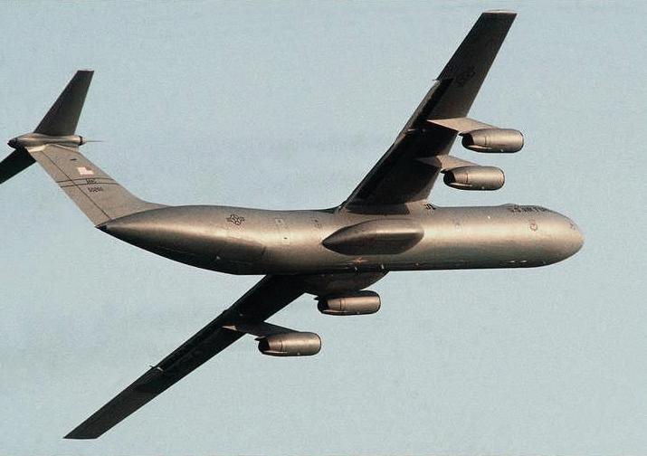
Could these pictures of a C-141 be your aircraft?
I apologize, but I’m not sure how to put the photo in the post.
http://www.richard-seaman.com/Wallpaper/Aircraft/NonCombatants/C141DroppingContainers.jpg
http://www.fas.org/man/dod-101/sys/ac/c-141-dfst9303042.jpg
This would be pretty easy to explain as several C-141s are used at March Air Reserve Base for a medical evacuation squadron stationed there.
The low flights and terrain following might be training for an environment similar to Afghanistan.
Touch’n Go at Mojave (MHV) airport.
Your theory concerning the small plane “hugging” the larger one has merit. I recall that one of the pilots who claimed to have flown drugs for Barry Seal (into Mena, AR) testified that they used exactly that technique.
When passing over a radar surveilled area, two A/C would fly close together — to image as a single blip on radar. Then, when they reached the edge of the radar’s coverage, they would descend just below the radar coveage, and the drug-carrying A/C would dive down to tree-hugging height. Then the decoy A/C would fly back up into radar view, and head off in another direction...
“The air space over the Mojave desert is extremely well monitored as several military bases are located in the heart of the region, on of which contains a space shuttle landing strip Edwards AFB.”
NAS China Lake is in the Mojave too.
Nothing flies in or out of that region without being noticed. Especially with China Lake which test Naval weapons. They have tracking that goes beyond typical aircraft radar, since they are testing every kind of air-to-air, surface-to-air and other sophisticated weapons that fly at all altitudes. Nothing can “fly in under the radar” in those parts.
Or SB+S — shoot, bulldoze and shutup!
I’ve gone through this post and have a theory. What if they are civilian/military flights associated wtih Boeing/Northrop/Raytheon?etc. You stated they were headed out to the desert which is were most of the testing grounds are for the So cal branches. A photo or video would be good also, a tail number. Keep a disposable camera handy in your car, etc. They come in quite handy in times like this. ;o)
That's a good policy for everyone! I do, because my company requires us to have one in case of an accident, etc. I've replaced it many times because I used them for personal reasons, and I am damn glad I had it.
exactly. I do the same thing. Have one in every car.
NAS China Lake is in the Mojave too.”
NAS China Lake is in Ridgecrest—about 80 miles from Mojave. Further north and east- continue east on Hwy 14 and it connects with US 3295, then on north to Ridgecrest. The NAS is on the EAST side of Ridgecrest.
US 3295”
US 395 sorry
Also- I think NAS China Lake is much closer to Trona dry lakes.
There are a number of dry lakes in that whole area, but I don’t know how long they are and what length a plane of this size would require to land or take off.
Sure sounds spooky, tho.
Disclaimer: Opinions posted on Free Republic are those of the individual posters and do not necessarily represent the opinion of Free Republic or its management. All materials posted herein are protected by copyright law and the exemption for fair use of copyrighted works.