I've always wondered since that "brochure" was first posted years ago if someone had the "key/legend" to the map. Somebody seemingly went to an awful lot of trouble to "color code" the countries, but as far as I can tell, there is no explanation of the colors (on this front side that is shown). The exception being that explanation of green as "muslim majorities in muslim countries" in the box to the left of South America.
The green countries are those with significant Muslim populations. But they are not all "Islamic" countries. Most of the ones in West Africa are not even majority Muslim. Uganda also certainly is not. Neither is Cameroon. Why is Tanzania crosshatched as an entire country while the Muslim provinces of Russia and Xinjiang in China are also crosshatched green? Why are Angola, Madagascar, Mexico, Paraguay, Ukraine, and Venezuela brown? What (if anything) do they have in common? What do the United States, Mongolia, Papua New Guinea, Indochina, Ethiopia, Poland, and Finland have in common?
Inquiring minds want to know.
Without knowing more about the "World Islamic Mission" and/or their first source of the map (where they got it), I'd assume they are the Islamic equivalent of Lyndon LaRouche (and conspiracy theories abound in that "milieu" far more than here). For them, our "late night UFO talk radio" nonsense is mainstream programming.
Probably somebody from some mosque in Jersey in the late 90s went to visit one of the "brothers" in jail who was having a "vision" that day since the guards forgot to give him his meds. So that Muslim "brother", living on a whole new "plane of existence", drew this with crayons as part of the prison afternoon "relaxation therapy" class. It looks like the "kiddie menu" at a Burger King after a five-year-old has finished with their artwork.
I've always thought the map displayed more irrational and disorganized insanity that purposeful and deliberative intelligence. Maybe a "key" to the colors would disabuse me of that notion. But until I see some sign of intelligent life, I'll continue to assume there is none behind this map.
Hi callmejoe. I think the key color is green. Green and non-green. The extremists want nothing less than a world Caliphate. The map I posted was removed from the original site (also no longer available) just before 911.
I only have time for a quick search right now, but here is something... More background at little green footballs:
3/5/2005: The United States of Islam
The Internet Archive’s Wayback Machine is a wonderful tool, containing more than 30 billion web pages archived from 1996 to a few months ago. It’s a good place to look for sites that no longer exist on the web, if you know the site’s former address.
Here’s one, which was apparently removed from the Internet some time around July 2001: New World Order Known As Muttahida Jihad Council. (Hat tip: Kae.)
The former Muttahida Jihad Council site featured the following map prominently; please note the small map at lower right labeled “After 100 Years.”
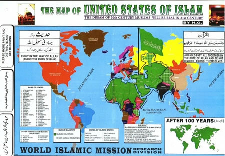
THE MAP OF UNITED STATES OF ISLAM.
THE DREAM OF 20th CENTURY MUSLIMS WILL BE REAL IN 21st CENTURY.
FIGHT IN THE WAY OF ALLAH (AGAINST THE ENEMY OF ISLAM). AND HOLD FAST, ALL TOGETHER BY THE ROPE OF ALLAH AND BE NOT DIVIDED AMONG THEMSELVES.
MUSLIM MAJORITY
[Green]MUSLIM COUNTRIES
[Non Green]NON MUSLIM COUNTRIES
DETAILS OF ISLAMIC STATES
CAPITAL: ONLY MAKKA, BUT NOT SAUDI’S FAMILY ARABIA
HEAD OF STATE: REHNUMA
NAME OF CURRENCY: ISLAMIC DINAR
RULE & LAW: QURAN & HADEES
ISLAMIC FLAG: BLACK BACKGROUND WITH WHITE KALMA PRINT
RESULT
ALL RESOURCES AVAILABLE IN ISLAMIC STATES.
BIGGEST ARMY IN THE WORLD
STRONGEST CURRENCY IN THE WORLD.
LARGEST COUNTRY IN THE WORLD.
ATOMIC & SUPER POWER COUNTRY.
EUROPE & U.S.A. CAN NOT SEIZE ASSESTS IN FUTURE OF MUSLIM UMMAH (COMMUNITY)
THE HEART OF GLOBE IN MUSLIM HAND.
MORE THEN HALF POPULATION OF WORLD IN ISLAMIC STATE.
A link to the Muttahida Jihad Council web site still exists on this page: Islamic Web Sites, under the title “NYC United States of Islam.” [DLN NOTE: The NYC United States of Islam website also no longer exists following little green football's reference a few months ago.]