To: John Jamieson
Found this: It shows the back corner (green line) being open marsh. The protective wall(more like a fill bulkhead) outlined in red/pink is there to keep tidal surges out of the lake. I'm guessing the flooded areas to the south of the lake are what is backing up the flow.
This area by nature drains very, very slowly. I don't know that blowing the bulkhead would speed up the process that much faster but it would definitely lead to more disaster later on when storm surges could enter the lake unimpeded over a wider swath than they can now.
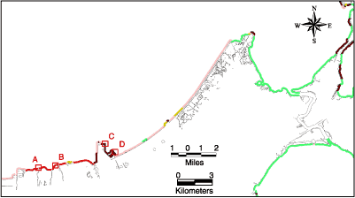
http://pubs.usgs.gov/of/2002/of02-206/geology/sepontchartrain.html
4,087 posted on
08/31/2005 3:09:35 AM PDT by
Rebelbase
("Run Hillary Run" bumper stickers. Liberals place on rear bumper, conservatives put on front bumper)
To: Rebelbase
It would be easy to fix after it's removed and the levels equalize. Good find. I'll study it some more.
I assume black line is concrete or steel?
4,089 posted on
08/31/2005 3:15:22 AM PDT by
John Jamieson
(Hybrids are a highway around CAFE, that's all they're good for.)
To: Rebelbase
Looks to me like it still could widened quickly and repaired later.
4,092 posted on
08/31/2005 3:22:37 AM PDT by
John Jamieson
(Hybrids are a highway around CAFE, that's all they're good for.)
FreeRepublic.com is powered by software copyright 2000-2008 John Robinson