Free Republic
Browse · Search
News/Activism
Topics · Post Article

Skip to comments.

NASA Continues To Roll In Pictures From Mars

Posted on 03/27/2004 7:35:06 AM PST by Bush Cheney


Large Version


Large Version


TOPICS: Miscellaneous; News/Current Events
KEYWORDS: jpl; mars; nasa
NASA has out-done itself again!
1 posted on 03/27/2004 7:35:07 AM PST by Bush Cheney
[ Post Reply | Private Reply | View Replies]

To: Bush Cheney
Kerry speaking at a college ridiculed the president for his concern about student athletes using steroids and his plan for going to the moon.
2 posted on 03/27/2004 7:43:31 AM PST by OldFriend (Always understand, even if you remain among the few)
[ Post Reply | Private Reply | To 1 | View Replies]


Spirit spent close to 4 hours RAT'ing on "Mazatzal", rock of the week. It made an 1/8th inch indentation in a couple of spots.

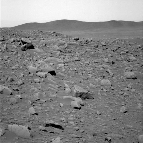
"Mazatzal" Rock on Crater Rim

NASA's Spirit took this navigation camera image of the 2-meter-wide (6.6-foot-wide) rock called "Mazatzal" on sol 76, March 21, 2004. Scientists intend to aggressively analyze this target with Spirit's microscopic imager, Mössbauer spectrometer and alpha particle X-ray spectrometer before brushing and "digging in" with the rock abrasion tool on upcoming sols

Mazatzal stood out to scientists because of its large size, light tone and sugary surface texture. It is the largest rock the team has seen at the rim of the crater informally named "Bonneville." It is lighter-toned than previous rock targets Adirondack and Humphrey. Its scalloped pattern may be a result of wind sculpting, a very slow process in which wind-transported silt and sand abrade the rock’s surface, creating depressions. This leads scientists to believe that Mazatzal may have been exposed to the wind in this location for an extremely long time.

The name "Mazatzal" comes from a mountain range and rock formation that was deposited around 1.2 billion years ago in the Four Peaks area of Arizona.

Image credit: NASA/JPL
Browse Image (54 kB) | Large (602 kB)

3 posted on 03/27/2004 8:39:51 AM PST by NormsRevenge (Semper Fi Mac ... Support Our Troops! ... Thrash the demRats in November!!! ... Beat BoXer!!!)
[ Post Reply | Private Reply | To 2 | View Replies]

To: Phil V.
fyi
4 posted on 03/27/2004 8:41:02 AM PST by NormsRevenge (Semper Fi Mac ... Support Our Troops! ... Thrash the demRats in November!!! ... Beat BoXer!!!)
[ Post Reply | Private Reply | To 3 | View Replies]

To: Bush Cheney
Those are very, very interesting photos. I don't immediately see anything that looks obviously biological, but there are some strange anomalies in a couple of the photos. I find "Mudpie" to especially interesting because there is no sign of any fluid flow (wind or water) around the larger solid objects (which I'll call pebbles, until I get an idea of scale.) The matrix looks like a fine sandstone, typical of a wind-blown area, but the pebbles looks like they were just softly set there. An impact would leave an eject signature (like a splash from a water drop). The matrix looks "wrong" for concretion formation. It's all very odd - and I've got to get to my kid's game this morning!

I'll be back.

5 posted on 03/27/2004 9:43:22 AM PST by capitan_refugio
[ Post Reply | Private Reply | To 1 | View Replies]

To: Bush Cheney; cogitator
Calling all geologists bump!

Cogitator - could you pass this along to you Geology Photo of the week ping list?

Thanks, CR

6 posted on 03/27/2004 9:47:05 AM PST by capitan_refugio
[ Post Reply | Private Reply | To 1 | View Replies]

To: 2Trievers; headsonpikes; Pokey78; Lil'freeper; epsjr; sauropod; kayak; Miss Marple; CPT Clay; ...
** ping **
7 posted on 03/29/2004 7:36:59 AM PST by cogitator
[ Post Reply | Private Reply | To 6 | View Replies]

To: cogitator; All
My question to the geologists on cogitator's ping list is, given that some of those grains are angular, sub-angular, and sub-rounded, are the fully rounded grained due to abrasion (rolling, etc.) or do you think they are concretionary (i.e. chemical)?

The fact that we have the whole range of angularity makes me suspect that the rounded grains are abraded. I still don't have a handle on scale, however.

And why do you think that there is no evidence of fluid flow around the larger grains in several of the photos, especially the one in the upper right corner? I pulled out my old copies of Reineck & Singh and Blatt, Middleton & Murray and found noting even remotely similar. Are we not looking at sediments? If so, is it so quiescent that there is no apparent turbulence wake or wake vortices?

8 posted on 03/29/2004 10:33:51 AM PST by capitan_refugio
[ Post Reply | Private Reply | To 7 | View Replies]

To: capitan_refugio
Though I have a strong interest in geology, my training is more geochemical, so things like petrography and sedimentary stratigraphy, both of which come into play here, are not my strong "suits".

But looking at the pictures, it appeared that the blueberries were falling out of the rocks, which would definitely point to the concretion identity. First thing that came to mind as a terrestrial analogue is oolites (click on this to see the full-size pic):

This next picture is of oolitic sand from Great Salt Lake, which is a decent analogue to the environment described at the Opportunity site:

From this Web site:

Oolitic sand at Stansbury Island, Tooele County

This page has some ugly-looking hematite concretions:

concretions

And this is a good article about the identity of the blueberries:

'Blueberries' Reveal Only Part of the Mars Water Story

This was posted before the press release that showed the stratigraphic layers interpreted as formed in shallow water.

Regarding your last question, and drawing on experience from when I visited Great Salt Lake one time: what they're talking about is a surface brine region. The water is going to be much denser (more saline), and the sediments are initially going to be "goopy" thick oozes that only over time will turn into rock. So though you can get layering as successive wet/dry cycles, this isn't a very active flow environment where you'd see evidence of water movement.

9 posted on 03/29/2004 1:52:23 PM PST by cogitator
[ Post Reply | Private Reply | To 8 | View Replies]

To: capitan_refugio
One other comment; the fracturing and angularity may be due to post-exposure weathering. I.e., the concretions all start out fairly rounded and spherical, but as they are exposed and dry out or simply crack, you'll get more angular grains.
10 posted on 03/29/2004 1:54:06 PM PST by cogitator
[ Post Reply | Private Reply | To 8 | View Replies]

To: cogitator
If you suppose that concretions are "rounded" then when you break a concretion you will get angular grains. So far so good. But we also have sub-angular and sub-rounded grains. It is hard to get those in the absence of erosion. In fact, it appears we have the entire continuum from very angular to well rounded.

My field experience is somewhat limited to the American Southwest, particularly the deserts and mountains of California, Nevada, and Arizona. So my observations are made with those parochial biases. (I have very little experience with carbonates, for instance.) However, I think some of the "desert pavements" I have seen bear a striking resemblance to Martian pictures.

11 posted on 03/30/2004 8:59:46 AM PST by capitan_refugio
[ Post Reply | Private Reply | To 10 | View Replies]

Disclaimer: Opinions posted on Free Republic are those of the individual posters and do not necessarily represent the opinion of Free Republic or its management. All materials posted herein are protected by copyright law and the exemption for fair use of copyrighted works.

Free Republic
Browse · Search
News/Activism
Topics · Post Article

FreeRepublic, LLC, PO BOX 9771, FRESNO, CA 93794
FreeRepublic.com is powered by software copyright 2000-2008 John Robinson