|
|
||||||||||||||||||||||||||||||||||||||||||||||||||||||||||||||||||||||||||||||||||||||||||||||||||||||||||||||||||||||||||||||||||||||||||||
|
 |
||||||||||||||||||||||||||||||||||||||||||||||||||||||||||||||||||||||||||||||||||||||||||||||||||||||||||||||||||||||||||||||||||||||||||||
|
|
||||||||||||||||||||||||||||||||||||||||||||||||||||||||||||||||||||||||||||||||||||||||||||||||||||||||||||||||||||||||||||||||||||||||||||
|

(Updated every six hours.) |
||||||||||||||||||||||||||||||||||||||||||||||||||||||||||||||||||||||||||||||||||||||||||||||||||||||||||||||||||||||||||||||||||||||||||||
|
|
||||||||||||||||||||||||||||||||||||||||||||||||||||||||||||||||||||||||||||||||||||||||||||||||||||||||||||||||||||||||||||||||||||||||||||
|
( Updated every three hours.) |
||||||||||||||||||||||||||||||||||||||||||||||||||||||||||||||||||||||||||||||||||||||||||||||||||||||||||||||||||||||||||||||||||||||||||||
|
|
||||||||||||||||||||||||||||||||||||||||||||||||||||||||||||||||||||||||||||||||||||||||||||||||||||||||||||||||||||||||||||||||||||||||||||
|
||||||||||||||||||||||||||||||||||||||||||||||||||||||||||||||||||||||||||||||||||||||||||||||||||||||||||||||||||||||||||||||||||||||||||||
|
|
||||||||||||||||||||||||||||||||||||||||||||||||||||||||||||||||||||||||||||||||||||||||||||||||||||||||||||||||||||||||||||||||||||||||||||
|
||||||||||||||||||||||||||||||||||||||||||||||||||||||||||||||||||||||||||||||||||||||||||||||||||||||||||||||||||||||||||||||||||||||||||||
|
|
||||||||||||||||||||||||||||||||||||||||||||||||||||||||||||||||||||||||||||||||||||||||||||||||||||||||||||||||||||||||||||||||||||||||||||
|
||||||||||||||||||||||||||||||||||||||||||||||||||||||||||||||||||||||||||||||||||||||||||||||||||||||||||||||||||||||||||||||||||||||||||||
|
|
||||||||||||||||||||||||||||||||||||||||||||||||||||||||||||||||||||||||||||||||||||||||||||||||||||||||||||||||||||||||||||||||||||||||||||
|
 |
||||||||||||||||||||||||||||||||||||||||||||||||||||||||||||||||||||||||||||||||||||||||||||||||||||||||||||||||||||||||||||||||||||||||||||
|
|
||||||||||||||||||||||||||||||||||||||||||||||||||||||||||||||||||||||||||||||||||||||||||||||||||||||||||||||||||||||||||||||||||||||||||||
|
||||||||||||||||||||||||||||||||||||||||||||||||||||||||||||||||||||||||||||||||||||||||||||||||||||||||||||||||||||||||||||||||||||||||||||
|
||||||||||||||||||||||||||||||||||||||||||||||||||||||||||||||||||||||||||||||||||||||||||||||||||||||||||||||||||||||||||||||||||||||||||||
|
|
||||||||||||||||||||||||||||||||||||||||||||||||||||||||||||||||||||||||||||||||||||||||||||||||||||||||||||||||||||||||||||||||||||||||||||
|
|
||||||||||||||||||||||||||||||||||||||||||||||||||||||||||||||||||||||||||||||||||||||||||||||||||||||||||||||||||||||||||||||||||||||||||||
|
|
||||||||||||||||||||||||||||||||||||||||||||||||||||||||||||||||||||||||||||||||||||||||||||||||||||||||||||||||||||||||||||||||||||||||||||
|
||||||||||||||||||||||||||||||||||||||||||||||||||||||||||||||||||||||||||||||||||||||||||||||||||||||||||||||||||||||||||||||||||||||||||||
|
||||||||||||||||||||||||||||||||||||||||||||||||||||||||||||||||||||||||||||||||||||||||||||||||||||||||||||||||||||||||||||||||||||||||||||
|
|
||||||||||||||||||||||||||||||||||||||||||||||||||||||||||||||||||||||||||||||||||||||||||||||||||||||||||||||||||||||||||||||||||||||||||||
|
|
|||||||||||||||||||||||||||||||||||||||||||||||||||||||||||||||||||||||||||||||||||||||||||||||||||||||||||||||||||||||||||||||||||||||||||
|
|
||||||||||||||||||||||||||||||||||||||||||||||||||||||||||||||||||||||||||||||||||||||||||||||||||||||||||||||||||||||||||||||||||||||||||||
|
|
Posted on 04/02/2003 9:13:57 AM PST by Sabertooth
N/A N/A
N/A N/A
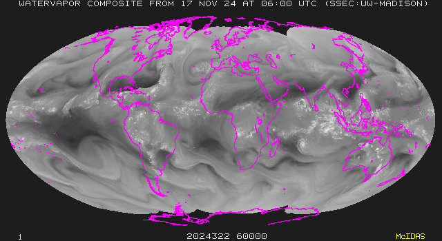
(Updated every six hours.)
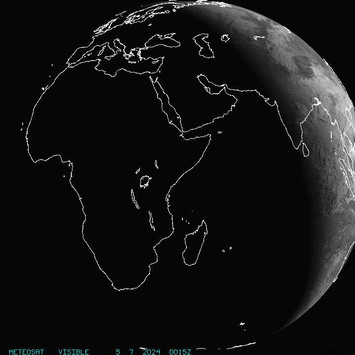
( Updated every three hours.)

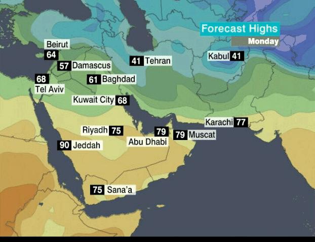
(Updates every six hours)
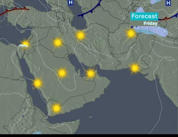
(Updates every six hours)


![]()
WEDNESDAY
MORNING
AFTERNOON
EVENING
NIGHT
Conditions
![]()
Sunny. Refreshingly cool.![]()
Clear. Cool.
Temp.
62° F
54° F
Wind Speed / Dir.
7 mph / ENE
9 mph / E
Humidity
23%
26%
Comfort Level
62° F
52° F
Visibility
35 miles
32 miles
6-Hour Precip. Probability
0%
0%
6-Hour Precip. Total
THURSDAY
MORNING
AFTERNOON
EVENING
NIGHT
Conditions
![]()
Mostly sunny. Mild.![]()
Mostly sunny. Pleasantly warm.![]()
Sunny. Mild.![]()
High level clouds. Mild.
Temp.
76° F
90° F
69° F
66° F
Wind Speed / Dir.
9 mph / SE
11 mph / SE
9 mph / ESE
11 mph / ESE
Humidity
21%
13%
22%
22%
Comfort Level
77° F
86° F
69° F
66° F
Visibility
38 miles
47 miles
37 miles
37 miles
6-Hour Precip. Probability
0%
0%
0%
0%
6-Hour Precip. Total
FRIDAY
MORNING
AFTERNOON
EVENING
NIGHT
Conditions
![]()
Mostly sunny. Pleasantly warm.![]()
Sunny. Awfully hot.
Temp.
82° F
97° F
Wind Speed / Dir.
13 mph / SE
13 mph / SSE
Humidity
20%
16%
Comfort Level
80° F
93° F
Visibility
39 miles
44 miles
6-Hour Precip. Probability
0%
0%
6-Hour Precip. Total


|
|
|
|

Select "Iraq" or whatever country you want to know about.
Try here.
Click on the IRAQMAPS keyword just above post #1 for some Freeper map threads.
Here's one that I've found...
Notice the 4th jpeg from the bottom. Notice the five large and strange circular and one oblong cloud patterns near the center/left portion of the photo. Could we be looking at contrails from refueling aircraft in loiter mode?
(These strange cloud patterns can be seen more clearly if you go to the larger original jpeg of that particular photo.)
--Boot Hill
I saw those too, and they certainly don't seem natural. The H2 and H3 airbases we captured out in Western Iraq are in that general vicinity.
If you'd like to be on the Iraq Weather and Maps ping list, post here to the thread. Thanks.
Hope our boys get a little of that after they wrap this up.
A little trivia: the word "chemical" is derived from "Khemt," the ancient name of Egypt.
Well, after a few rounds of B-52s.
It's also my understanding that the heat has an effect on chemicals also and makes them less effective
Very interesting both for what it shows us and for what this says about the kind of info that the military is not concerned that the Iraqis know.
--Boot Hill
True. BTW, there were a couple of days last week where the Iraqi satellite pics weren't available, and I see a couple more have been deleted from the archive. Makes you wonder.
Disclaimer: Opinions posted on Free Republic are those of the individual posters and do not necessarily represent the opinion of Free Republic or its management. All materials posted herein are protected by copyright law and the exemption for fair use of copyrighted works.

