
Posted on 10/31/2022 7:58:13 PM PDT by RomanSoldier19
The Mighty Mississippi might need a new nickname. North of Memphis, the river looks more like a desert than a river, as barge traffic up and down the crucial corridor is slowed or stranded amid a historic drought.
Paul Rohde, who represents the river's shipping and towing industry, says the Mississippi is plunging to record low levels just as farmers send their harvests down river for export.
"It's stark. We are seeing operational challenges that are almost unprecedented," said Rohde, Waterways Council vice president of the Midwest area. "One-twelfth of the world's population eats something that emanates from the Mississippi River Basin. Forty percent of the global food supply starts at the Mississippi River Basin. So this is a serious issue about who's going to feed the
(Excerpt) Read more at cbsnews.com ...
Good time to get rid of Asian carp.


Viewing the river yesterday from Arkansas places that used to be called islands are now peninsulas.
A friend of mine is going dirt bike riding in the sand this coming weekend.
(Brown beans, brown corn, brown cotton, brown rice, it’s all gone)
It the same looking across from Memphis to Arkansas. The barges go past all day, and we have peninsula that reach from the Arkansas side that are @ 50 to Mud Island.
We had rain over the weekend, but didn’t seem to notice any negligible change to peninsulas.
Only a massive government program and higher taxes can fix this...
Wasn’t long ago that folk were talking up shifting water from Mississippi River to Colorado river. To feed California, which lets its own river water flow to the sea to protect minnows. And is unwilling to harvest any water from the puddle along its left flank.
I just can’t imagine why we are experiencing so many natural disasters. Almost like a woman in labor.
Our cabin is on the upper Mississippi River where it flows from Big Wolf Lake in northern Minnesota. There was ample snowfall so that river levels were at record highs this spring. Mississippi river levels at our cabin remained high all summer due to frequent rains. Hard to believe that downstream there were record low water levels.
Great time to be running out of diesel, too!
The Mississippi River at Grand Tower IL rose a couple feet last Wed-Th due to some regional rains — and then the level literally fell off a cliff, in one reporting period (30 min), back to the previous level or lower.* I’ve NEVER seen such a drop at any station, not even when the ACE blew the levee at Birds Point some years back, to relieve flooding. I’m guessing a gauge malfunction, as immediately prior to the drop some data is missing, but, still, a good rain had no lasting benefit for the river... :-(
*The Mississippi is so low, people have been walking over what was river to “Tower Rock”, quite unusual.
The gauge upriver at Chester shows a more typical rise and falloff, then a bit of a rise again due to a bit more rain, but is still very low and expected to fall ~ 2ft. through next Sunday.
The Ohio River above the Olmsted lock and dam isn’t TOO bad, but below Olmsted the draining into the very low Mississippi has that last bit of the Ohio very low too. I visited it last Oct. 15 and was “like WOW!”
ACE has been releasing water at KY Lake and Lake Barkley to try to help out on the Mississippi.
It might make sense to try to store and send spring floodwaters west, but, given this present situation, ACE may have to consider more water storage simply to get through droughts in the Mississippi watershed. It’d have to be a truly massive project, and crazy cost overruns like those on the Olmsted Lock & Dam project, on the Ohio River, just could not be tolerated...
“Screw” EV charging stations — we gotta keep these rivers open to traffic.
Consider the present then compare the flood of 1927. The river’s potential range is too great when most of its half continental watershed hits either extreme. Dams on the lower river to maintain minimum channels, such as were put on the upper river would be too expensive to be cost effective and would slow traffic too much there most of the time. And the only place big enough to hold the periodic really big floods is the ocean. The water just can’t get there fast enough. The only thing that affects the ocean storage is glaciation: often 300-400 feet lower so early men could walk to Australia, England, Taiwan, Chicago… potentially 200 feet higher in which some small islands drown but many ‘new’ ones separate from old lowlands. In either case mere men, humbled by nature, move and adapt.
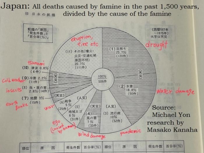
A Japanese who collaborates with Michael Yon found this in a very old history text book.
Seems like it’s only a couple of months ago that a lot of people on FreeRepublic were all gung-ho for pumping water from the Mississippi west into the Colorado River.
I remember that.
At that time, I would have thought that a drought crippled Mississippi river would be ridicolous.
Seems like many, many unusual things in the world are 'messing with' the food supply.
Disclaimer: Opinions posted on Free Republic are those of the individual posters and do not necessarily represent the opinion of Free Republic or its management. All materials posted herein are protected by copyright law and the exemption for fair use of copyrighted works.