Jigsha Desai, USA TODAY NETWORK
May 30, 2022, 10:19 AM·
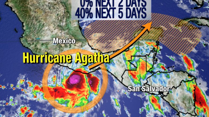
Just days before the official start of the 2022 hurricane season, Hurricane Agatha is barreling toward Mexico’s southwestern coast Monday, forecasters at the National Hurricane Center said. The storm is expected to make landfall in southern Mexico later today.
Hurricane Agatha is the first named storm of the 2022 Pacific season.
Some spaghetti models show Agatha’s impact to Florida
Some spaghetti models show that Florida will be impacted by the storm’s remnants after it crosses over Mexico.
Use the map to below to see the different models.
AccuWeather meteorologists said that Agatha, as it crosses Mexico and enters the Bay of Campeche in the next few days, could redevelop into the Atlantic basin’s first named storm. If formed, that storm would be called Alex.
A large and complex area of low pressure is expected to develop across Central America, the Yucatan Peninsula and the southwest Gulf of Mexico in a few days, partially related to the remnants of Hurricane Agatha from the eastern Pacific.
Experts predict “above-average” hurricane activity this year
Forecasters at NOAA’s Climate Prediction Center are predicting above-average hurricane activity this year — which would make it the seventh consecutive above-average hurricane season. Forecasters predict a 65% chance of an above-normal season, a 25% chance of a near-normal season and a 10% chance of a below-normal season.
What The MS Coast Needs To Know About Hurricane Agatha: Strength, Forecast, More
Hurricane Agatha likely will be on the cusp of Category 3 strength when the storm makes landfall in Mexico on Monday afternoon, the National Hurricane Center said in its 10 a.m. update.
The storm has maximum winds of 110 mph and is expected to maintain those wind speeds as it moves inland. The core of the storm is expected to move over the state of Oaxaca, Mexico, the National Weather Service said.
“The satellite presentation of the system has been (in a) relatively steady state for the past several hours, with hints of an eye occasionally appearing within the central dense overcast,” the NWS said in its 10 a.m. discussion. “Convection remains quite deep and symmetric around the center.”
Bands of rain are already falling across southern Mexico, and the country should prepare for “life-threatening winds” and “destructive waves” on the east side of the system. Flash flooding and mudslides are also possible, the NWS said.
10 am CDT May 30: Hurricane #Agatha nearing the coastline of southern Mexico, landfall expected this afternoon. Here are the latest Key Messages. Visit https://t.co/Oy8uof9ldM for details. pic.twitter.com/kaCD3u2I57
— NHC Eastern Pacific (@NHC_Pacific) May 30, 2022
Agatha is expected to quickly weaken once it makes landfall, but there is a chance for redevelopment in the Gulf of Mexico. Here’s what you need to know from the National Hurricane Center:
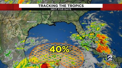
•As of 10 a.m. Monday, there’s a 40% chance the remnants of Agatha could develop into a tropical system in the southwest Gulf of Mexico, near the Yucatan Peninsula, later in the week.
•“Some gradual development is possible within this system in the far southwest Gulf of Mexico around mid-week or in the northwest Caribbean by the latter part of this week as it drifts eastward or northeastward,” the NWS said.
•The area of low pressure will dump heavy rain on southern Mexico, Guatemala and Belize later in the week.
•If the system strengthens into a tropical storm or hurricane once it hits the Gulf, it would be Alex, the first named storm of the 2022 Atlantic hurricane season.
•The system is not expected to be felt on the Mississippi Coast, but weather forecasters in Florida are keeping a close eye on Agatha and the potential Gulf redevelopment.


