And 3 degree Mon night!
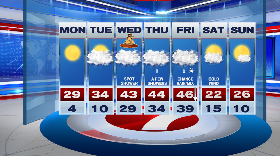 https://whdh.com/weather-blog/cold-monday-some-melting-mid-week/
Posted on 01/29/2022 4:33:58 AM PST by caww
...More than a foot of snow had fallen in New Jersey by early Saturday morning.
...Rhode Island issued a travel ban for all non-emergency vehicles on Saturday...
....A snow emergency was declared in Boston..
....Maryland activated National Guard troops.
....Coastal residents in one Massachusetts town were told to consider leavin
(Excerpt) Read more at weather.com ...
However, REAL maple syrup is mandatory.
Which makes this whole Russian invasion of the Ukraine a strange thing.
They know the history of success of nations invading them in the middle of a Russian winter. It’s a guaranteed losing proposition for the invader.
What are they thinking?
I do want to get that.
Well, Afghanistan’s Quagmires go all the way back to Alexander the Great.
And yet, countries still try to go there and “Fix” it.
People don’t seem to learn from History, even when it ISN’T being suppressed.
And when the Truth is covered up, it’s even worse!
.
No argument from me at all on that.
If it comes down to -
Q: "What was his cause of death?"
A: "It's the darndest thing - Looks like a maple syrup overdose..."
So be it.
Amen!
And 3 degree Mon night!
https://whdh.com/weather-blog/cold-monday-some-melting-mid-week/
A real heat wave.
We won’t be so warm.
Spoken like a Frozen chosen
“In PA the deeper in color and thickness of deer skins indicates how cold and bad the coming winter will be. This year their coats were darker and thicker.”
There are a lot of deer around here and often visit the bird feeder outside the window. Their coats are exceptionally dark this winter and it’s been well below normal temps here in the mountains of NC.
Yep....I heard this some time ago and began paying attention. My son has deer crossing his yard while we’re on the deck...often 6 or more. It was noted here how dark their fur was this year as well.
Nature reveals so much if just take the time to observe.
We got 20 inches in my town. A town nearby got 30 inches.
I didn’t know that she (Shelby Scott) passed away this summer.
It must have been on the local Boston news.
Hubby and I sold our house and moved to the South this summer.
Based on the weather alone (not to mention the politics)
we made the right decision.
RIP, Miss Scott.
Oh wow...that’s plenty! I got none of it here but had 8 inches the storm prior and looks like another one is on it’s way.
>>>The verb קנן (qanan) isn’t used in the Bible but it appears to tell of the weaving of many strands into a dynamic and interlocked network. These strands may be reeds and twigs that a bird weaves into a nest, or it may be acts of trade and routes of commerce that together combine into a bustling economy. Noun קן (qen) means nest, and verb קנן (qinnen) means to make a nest.<<<
That’s interesting.
They’ve begun naming winter storms?
We have become such wimps (collectively.)
Man, I remember growing up in Southeast Asia reading about all of the snow problems over here. We enjoyed beautiful weather, smelled the flowers and had wonderful Asian food. Nothing was frozen. Just a little bit of TET Offensive, that’s all. Then we came back to Texas. More of almost the same, minus the TET Offensive. It’s rough down here.
You must have been south of all that fun my brother had in Austin last winter.
Fairly significant icing event shaping up in the Mid-South. It looks like the people in Mayfield, KY* trying to recover from the monster tornado in December are gonna get clonked again. Even we could get 1/2” of ice, plus a good dose of sleet and some snow.
Forecast discussion out of the Paducah, KY, NWS:
000
FXUS63 KPAH 021116
AFDPAH
Area Forecast Discussion
National Weather Service Paducah KY
516 AM CST Wed Feb 2 2022
.SYNOPSIS...
Issued at 415 AM CST Wed Feb 2 2022
...First Major Winter Storm for the Quad State in 2022...
Key Messages:
1. This winter storm is just beginning to move into the Quad
State area early this Wednesday and impacts could be felt as
early as mid-morning over extreme southwest Illinois. Confidence
in minor to locally moderate impacts to residents of southeast
Missouri and southern Illinois remains high.
2. Recent and significant forecast changes in this winter storm
system suggest that a good portion of west Kentucky, southwest
Indiana, extreme southeast Illinois, and extreme southeast
Missouri could see significant icing from freezing rain. This will
likely cause major short term impacts and more prolonged extreme
impacts over a smaller part of the area. Therefore, the
aformentioned area has been shifted from a Winter Storm Warning
to a Ice Storm Warning.
3. For the Winter Storm Warning area, the time period for the
greatest snow accumulations will be over southern illinois between
6am and 6 pm Thursday. For ice accumulations, the time period for
the greatest accumulations will be this morning through midnight
over southern Illinois and southeast Missouri. For sleet
accumulations, the greatest accumulations will likely occur from
midnight to noon on Thursday, with amounts in excess of an inch
mainly over southeast Missouri. Finally ice accumulations due to
freezing rain will be most impactful for southeast Missouri today
(especially this afternoon) through midnight and over southern
Illinois this afternoon through midnight tonight.
4. For the Ice Storm Warning area, lighter (generally less than
one tenth of an inch) ice accumulation can be expected to move
into the western half of the warning area this Wednesday evening,
with 0.10 to 0.15 of inch accumulation from midnight to 6am
Thursday. The highest accumulations, ranging from two to four
tenths of an inch are expected between 6 am and noon on Thursday
covering the bulk of the Ice Storm Warning area. From noon to 6 pm
CST Thursday, the ice accumulations are expected be near one
quarter inch, focused wholly in west Kentucky. After 6 pm and
through midnight, additional ice accumulations are minimal across
the Pennyrile of west Kentucky.
5. There still remains some forecast uncertainty as to final
winter precipitation accumulations, due to prior air, ground, and
road conditions. In addition, smaller scale weather features in
this massive winter weather system may enhance or reduce
perception amounts. Regardless, this winter storm should be taken
seriously for both travelers and residents of the Quad State
region served by the National Weather Service in Paducah Kentucky.
&&
.SHORT TERM...(Today through Friday Night)
Issued at 415 AM CST Wed Feb 2 2022
Made some slight adjustments to the onset of the Winter Storm
Warning going into southeast Missouri and southern Illinois to
reflect the slightly faster drop in temperatures to near freezing
levels today. Originally the start time was at noon, but there is
some potential that some ice and sleet accumulations could develop
between 9 am and noon, accounting for latent heat release of the
rain and slowly cooling road surface temperatures that benefited
from Tuesday`s well above normal temperatures. Redefined the
Winter Storm Warning area to reflect the general mix of sleet and
freezing rain followed by the transformation to snow and sleet.
The snow impacts appear to be confined to the Southeast Missouri
Foothills and roughly west of a Carbondale to Wayne City Illinois
line.
Utilized the medium range model suite for overall background
temperature, dewpoint, wind, and sky cover, but incorporated the
HRRR, HREF, and NAM-WRF ARW high resolution guidance to refine
temperatures and precipitation amounts and timing.
More importantly, made a significant change from a Winter Storm
Warning to an Ice Storm Warning for the southeast half of the WFO
PAH forecast area. There is some expectation that precipitation
loading from the warm nose aloft into to the boundary layer will
hold temperatures above freezing along the leading edge of the
Arctic Cold front. This situation along with antecedent warm ground
conditions may delay impactful accumulations by 2-5 hours at the
onset.
However, as the entrance region of the cyclonic curved jet
max transits across the ice storm warning area between 06z and 18z
Thursday, the lift will sharpen the thermal profile and baroclinic
zone enough to increase QPF (precipitation amounts) through the
sub-freezing boundary layer. Unlike the 2009 storm, when the sub-
freezing layer was already in place and there was not a progressive
upper system transiting through the area, the duration of the
enhanced freezing rain will be somewhat shorter. Therefore, the
mean ice accumulations within ice storm warning are likely to be
near one half inch.
An additional concern with the tightening wind gradient Thursday
afternoon, with the potential for some wind gusts in excess of 25
to 35 mph Thursday afternoon. These wind gusts, combined with any
ice accumulations, could lead to stress on power systems and some
structures.
Even though significant adjustments have been made to many
infrastructure systems since the 2009 ice storm, cannot rule out
the potential for some tree damage and extensive power outages, as
well as significant travel problems with this winter storm event.
Kept some lingering, but very light snow and sleet into the
remainder of Thursday night, especially after midnight. Still have
some forecast concern that linger, sub-advisory snow flurries or
light snow may linger into Friday morning. With respect to single
digits
(Odd cutoff theirs, not mine.)
This new event (2/2-2/3/22) might be worth a separate thread, but I am gonna be too busy to mind a thread if I were to post it, so, maybe somebody else...?
Disclaimer: Opinions posted on Free Republic are those of the individual posters and do not necessarily represent the opinion of Free Republic or its management. All materials posted herein are protected by copyright law and the exemption for fair use of copyrighted works.