Posted on 01/02/2021 5:29:08 PM PST by BeauBo
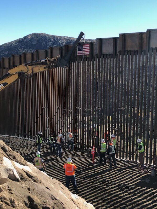
In May of 2020, 14.8 miles of Border Wall project began in the east county of SanDiego. Today the final panel was installed near Tecate.
(Excerpt) Read more at twitter.com ...
If Biden doesn’t knock it down.
nice, thanks!
Bidung: “What’s supposed to get knocked down?”
The ‘wall’ is an inanimate object. Controlling it is like ‘gun control.’ It blames an inanimate device for bad human behavior. What we need is a strong judiciary which will prosecute illegal incursions and not reward people who violate our sovereignty.
I agree with you.
He’ll knock down a few miles of it to make a political statement. The rest will stand.
Finish the wall!
I’ve finished a few Tecates in my day...
I used to run my TJ
From Campo to Tecate.
A couple strands of barb wire in spots.
Now it’s a
Big Beautiful Bollard!
They are chewing through the Mountains, heading East from Otay Mesa as well, to close the gap from San Diego to the pre-existing bollards, that were in the easier parts of the mountains.
California has been a huge winner in the Trump Border Wall Program.
The largely unseen detection technology that goes with Trump-Style 30 foot bollards, is some real game changing stuff as well.
The access roads for Border patrol through the Mountains is pretty huge as well.
Nice report.
Thanks.
Can you take an educated guess how much of the 140 miles of cali-Mex border has wall? New Mexico has 180 miles of border but the unbuilt parts now are low priority.
“Can you take an educated guess how much of the 140 miles of cali-Mex border has wall?”
I mainly watched the urban areas. First was the West side of Calexico, that got 2.25 miles. The East Side later got 11, finishing up that urban area. Tecate got some, Andrade got some, the Jacumba Wilderness got a long run (12 or 15 miles, something like that).
San Diego Of Course was the big deal. 14 miles, backed up by a 30 foot secondary. San Diego Project 4 extends that Urban barrier over a few miles of exceptionally steep rural terrain, to link up with a pretty lengthy run of pre-existing bollards through the mountains.
The extent of the pre-existing bollards is a big wild card for me to estimate the California total.
I’d guess that about 50 miles or more of the Cali border (not counting secondary barrier) got new Trump-style Super Wall System, and dozens more already had pre-existing bollards and patrol road, that were assessed as operationally effective. I just don’t know how much. I’d guess a majority of the 140 has bollards and road. Maybe 100 or more.
I just don’t have anything authoritative to go by. San Diego and El Centro Sector CHiefs know, but none of them post Border Wall updates anymore, since the election.
It seemed to me that the flats were mainly walled off by the Trump Program, and they were chewing into the hills and mountains. The areas left without barrier are predominately undrivable terrain. The urban areas got strong Super Wall System, with all the technology bells and whistles.
California was a huge winner in the Trump Program, and frankly, so were Arizona and New Mexico. They were all massively reinforced - transformed.
The CBP Commissioner recently mentioned that Arizona had completed over 200 miles of new Border Wall, under the Trump Program.
Arizona is also receiving complete coverage of their 370 mile border by the Integrated Fixed Towers (IFT) Program (which had been scheduled to complete at the end of 2020), in addition to several other layers of new technology.
Outside of Texas, the job is significantly done, especially if existing contracts complete work.
Yes, if 446 total miles minus 15 Texas miles puts 430 miles from El Paso to Pacific ocean. 230 miles left with CA maybe 100 miles and NM 67 miles leaves 65 miles or so that have no barrier now.
There is 221 miles of existing wall also to account for tho. Some would be in east AZ between San Pedro River and the mountains west of it. Maybe Otay Mesa has existing. Original San Diego wall and Yuma wall also.
Wonder if any of that 221 existing miles got into the 446 miles somehow.
I went to Campo,Forest Gate Rd. and went thru to the
Pacific Crest Trail terminus. Ignored the
Federal Warning signs back
in November. The fence and
Roads are Fantastic! I’ll
Visit Again and the place
Should be Open as Before.
Oops, 750 - 430 gives 320 miles to fit the 221 miles of existing in.
“Wonder if any of that 221 existing miles got into the 446 somehow”
I really doubt that. The 446 miles was completed from contracts awarded within the funded Trump Program (738 total). That money is tightly accounted for.
There is actually quite a bit more than 221 pre-existing miles left in place (of lesser quality) but those 221 miles were assessed to not need replacement, to meet he new standard of operational control. Typically 18 foot bollards (or bollard levee wall, around Brownsville, Texas), with good roads. Out side of the Bush-era levee wall around Brownsville (call that roughly fifty miles), I think the good pre-existing barrier of those 221 miles will be in the States West of Texas.
The Eastern flank of El Paso’s new barrier, while in the State of Texas, is within the Border Patrol’s El Paso Sector, that mostly covers New Mexico, so sometimes reporters misreport the Texas total, focusing only on the Rio GrandeValley. Del Rio Sector has been building just a few miles around their Port ofEntryas well.
Even if Texas could eke out a few more than 15 new miles, it is not going to be much. So if the other States got roughly 430 of the new miles, and 170 out of 221, that would be about 600 good miles (some of which is secondary barrier) out of about 750 miles of border, plus other areas with improved roads and sub-standard barrier.
Definitely, San Diego got 14 miles of secondary barrier out of the 446, but Yuma Sector got the most secondary
The Tohono O”odham Nation Indian Reservation in Arizona has about 60 miles of border with Mexico. They are getting no new barrier under the Trump Program, but are gettting/got Integrated Fixed Towers for persistent surveillance.
They have a mix of different types of pre-existing barriers and unfenced areas, that might account for some of the remaining gaps West of ElPaso.
Disclaimer: Opinions posted on Free Republic are those of the individual posters and do not necessarily represent the opinion of Free Republic or its management. All materials posted herein are protected by copyright law and the exemption for fair use of copyrighted works.