Posted on 09/12/2018 1:53:29 PM PDT by NautiNurse
“ARLO cameras will be up...”
What is an ARLO camera?
It’s going to be an interesting few days ahead.
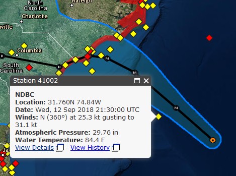
Most everyone is aware of the National Data Buoy Center’s website - but here’s a link to one particular buoy that’s right in the path of Florence.
https://www.ndbc.noaa.gov/station_page.php?station=41002
It may (to some out there) be worth bookmarking to keep an eye on wind speed, wave height, etc.
She’ll be fine. If Matthew and Irma didn’t close down HHI, this one won’t. Last forecast for HHI:
https://www.wunderground.com/forecast/us/sc/hilton-head-island/KSCHILTO37?cm_ven=localwx_10day
shows maybe 40mph winds. We get winds like that out of a thunderstorm. And they’ll be coming out of the NW, so, it will be blowing out to sea.
Do you know if she is on the south end or north end of the island?
” If Matthew and Irma didn’t close down HHI”
meaning that HHI was up and running very quick after the storm. I was over there a couple of weeks ago and all seemed quite normal.
Conway is a bit inland and slightly higher elevation. It’s better than being direct oceanfront in a hurricane making landfall nearby and at least that landfall is to the north or appears to be at present, the north side of landfall is reputedly the “dirty” side. They’ll experience high wind and heavy rain though. If in an even remotely flood prone area there will be problems, and if by a tidal creek or river of any size feeding into the ICW, there will be storm surge.
Here’s the solar powered cam on the decommissioned lighthouse at Frying Pan Shoals, about 32 miles out to sea off of Bald Head Island, NC. Getting pretty windy, can’t hear the gulls anymore, camera’s shaking slightly. Chop is picking up, occasional larger swells. Not much in the way of whitecaps yet. The cam is 60 ft above the water, for scale, rougher than you think. The US flag is flapping and snapping pretty hard. Nothing compared to what it will be like tomorrow, though.
Sorry about your awful day.
Best wishes.
The track keeps adjusting, and every time it still goes right over my house, and the amount of expected rainfall increases.
Went from not in the rain zone at all to being solidly in the 4-6” band, and if the trend continues I’ll be in the 6-10” band on the next update. Tropical storm force wind probability went from 10% to 40%, 50knot from 0 to 5%, still thankfully well out of the hurricane force probability band.
The only good news is that the storm is supposed to weaken earlier in its overland path.
Survived Irma all right here, no real damage, and this looks like Florence will be weaker than Irma when it arrives.
I bought some sympathy chocolate on the way home from work ;)
Looking back over the storm surge pictures from Katrina...just unimaginable. Those threads you did were just incredible...they went on and on forever, didnt they?
Pretty decent security camera system.
All that lumber .. my God .. wind and water simply deconstructed those properties !
Anyone with sense knows that even the best homes aren't forever, but to be taken apart stick by stick and piled up like so many boxes of spaghetti :-\
The word 'awesome' is way overused, but it surely applies to such as that.
This is reminding me of Fran in ‘96. It weakened from Cat 4 to Cat 3, but the windfields doubled in size. Like Fran, this looks to track up he Cape Fear river. Unlike Fran, this one may stall out over NC.
I’m glad to be watching from a safe distance in Dallas.
Just wish I was a youngster again to be able to lend a hand (and a couple chainsaws) with some of the relief efforts :-\
Try not to compare storms. I know it is hard. This storm is MEGA HUGE, anticipated to creep at a snail’s pace. That means whatever effects occur, they will occur much longer than another storm. At the very least, flooding and erosion are very real possibilities.
Up here in Western Pa. we are absolutely still saturated....any thing from Florence rain wise will not be good, that possiblity appears to remain.
I understand. Every time we dodge a big, bad storm, I donate my annual storm supplies the the unfortunate recipients of the damage. Seems there is always a local news station or church or other charitable organization organizing a truckload or plane load of post-catastrophic hurricane donations.
18z gfs just out has less of a stall ...is more onshore with the SW trip(weaker storm) and moves it out faster
better news..if true
Disclaimer: Opinions posted on Free Republic are those of the individual posters and do not necessarily represent the opinion of Free Republic or its management. All materials posted herein are protected by copyright law and the exemption for fair use of copyrighted works.