Skip to comments.
Hail, thunderstorms, powerful winds expected as new storm moves into L.A. Tuesday evening
Los Angeles Times ^
| 12/21/10
| Robert J. Lopez and Hector Becerra
Posted on 12/21/2010 11:41:08 AM PST by NormsRevenge
Southern California was bracing for another powerful storm front Tuesday evening as a sixth straight day of rain brought dramatic rescues, flooded freeways and concerns about mudslides.
According to the National Weather Service, scattered showers Tuesday will give way to heavy rain at night. Officials said the rain will continue into Wednesday with a chance of hail, high winds and thunderstorms. The weather service said the wind will be so strong in some mountain communities Wednesday morning that it could uproot trees. Gusts in some areas could top 65 mph.
The snow level is expected to drop to 4,500 feet.
...
Four men stranded in Orange County's Trabuco Canyon were rescued Tuesday morning when they were plucked from the flooded foothills by helicopter. The men were spotted soon after daybreak when the helicopter flew over the fast-moving Trabuco Creek and saw them inside their vehicle.
A woman who was swept away in her pickup while crossing a rain-swollen creek in the San Bernardino National Forest was rescued Monday night after a harrowing four-hour recovery effort, officials said. ..
More than 5 inches of rain have already fallen in downtown Los Angeles this month, and the record of 8.77 inches for December is within reach. Mammoth Mountain has already recorded the highest December snow levels ever.
(Excerpt) Read more at latimes.com ...
TOPICS: Culture/Society; US: California
KEYWORDS: california; hail; losangeles; stormwatch; thunderstorms
Navigation: use the links below to view more comments.
first previous 1-20, 21-40, 41-60, 61-70 next last
To: NormsRevenge; Brad's Gramma; A CA Guy; lainie; pollywog; ErnBatavia; bd476; Yaelle; Ron C.
I am late getting in here...rain has gone away for the moment...and I was hoping it was all over...
now you deliver this bad news....YUK!
Pinging others.
To: NormsRevenge
NWS from accuweather:
******************************************
FLASH FLOOD WATCH
in effect until Wednesday, Dec 22, 2:00 PM
..FLASH FLOOD WATCH REMAINS IN EFFECT THROUGH WEDNESDAY AFTERNOON...
THE FLASH FLOOD WATCH CONTINUES FOR
* A PORTION OF SOUTHWEST CALIFORNIA...INCLUDING THE FOLLOWING AREAS...APPLE AND LUCERNE VALLEYS...COACHELLA VALLEY...ORANGE COUNTY COASTAL AREAS...RIVERSIDE COUNTY MOUNTAINS...SAN BERNARDINO COUNTY MOUNTAINS...SAN BERNARDINO AND RIVERSIDE COUNTY VALLEYS-THE INLAND EMPIRE...SAN DIEGO COUNTY COASTAL AREAS...SAN DIEGO COUNTY DESERTS...SAN DIEGO COUNTY MOUNTAINS...SAN DIEGO COUNTY VALLEYS AND SANTA ANA MOUNTAINS AND FOOTHILLS.
* THROUGH WEDNESDAY AFTERNOON
* A FLOW OF MOISTURE FROM THE SOUTHWEST WILL CONTINUE PERIODS OF LIGHT TO LOCALLY MODERATE RAINFALL TODAY. FOR TONIGHT AND WEDNESDAY...A STRONGER...COLDER TROUGH OF LOW PRESSURE FROM THE NORTHWEST WILL BRING NUMEROUS SHOWERS AND SCATTERED THUNDERSTORMS FOR LATE TONIGHT THROUGH WEDNESDAY MORNING.
* FOR LATE TONIGHT THROUGH WEDNESDAY MORNING...HOURLY RAINFALL RATES UP TO ONE HALF TO ONE INCH ARE POSSIBLE IN THE MOUNTAINS. SCATTERED THUNDERSTORMS AND BANDS OF HEAVIER SHOWERS WILL HAVE HIGHER RAINFALL RATES WHICH WILL INCREASE THE POSSIBILITY OF RAPID FLOODING OF AREAS SATURATED BY RECENT HEAVY RAINFALL.
To: NormsRevenge
To: All
For those of us who didn't see last nights happenings....from Watts Up with That:
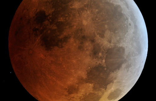
Total Lunar Eclipse on the Solstice – way cool

Photo details: 10″ Meade LX200, Nikon D300, prime focus,ISO 1250, 2s exposure
“It was an absolutely gorgeous night for an eclipse!” says Sabin.
Sabin’s photo captured not only the red light at the core of Earth’s shadow caused by sunlight filtering through the stratosphere, but also the “turquoise fringe” caused by our planet’s ozone layer. Pictures like this are golden for researchers who look at the colors of eclipses to diagnose the state of Earth’s atmosphere. See “All-Clear in the Stratosphere,” below.
more images: from Rod Lindley of Dallas, TX; from Kevin R. Witman of Cochranville, Pennsylvania; from John W. O’Neal, II of Amherst, Ohio; from Evan Ludes of Omaha, Nebraska; from John Stetson of Southport, CT; from Mark A. Brown of Carlisle, Pennsylvania; from Giancarlo Ubaldo Nappi of Belo Horizonte MG, Brazil; from Phil Harrington of Long Island, NY; from Mike Mezeul II of Sachse, Texas
See the Lunar Eclipse Photo Gallery
To: All
Current radar for SoCal:

To: Ernest_at_the_Beach
The eclipse was BEAUTIFUL here in Central Florida...yawn...but...yawn..I had to go to bed after a few minutes of watching. Got up at 6..long day:)
Good luck to all you FReepers getting slammed by these storms in California...stay dry and safe.
26
posted on
12/21/2010 1:30:36 PM PST
by
SE Mom
(Proud mom of an Iraq war combat vet)
To: BelegStrongbow
Beleg,
I understand you amusement.
But,
I lived in L.A. off and on for 25 years.
I saw three thunderstorms in that time.
Mostly a kind of fog,misty rain for a week or two even. BUT actual thunderstorms that drop inches of rain in hours?
Most folks do not know that L.A. is actually a desert.
I live in S. E. Florida now and we get 5, 6 inchs an hour at times but are prepared with drainage etc.
L.A. gets 2 inches in an hour and I wouldn’t go out of the house.
If it snowed I wouldn’t get out of bed that day.
To: SE Mom
Thanks for the kind words .
This mist and rain has been going on forever it seems.
To: Joe Boucher
My suggestion that LA was undergoing biblical storms was not an expression of amusement. Sorry if it came off that way. LA is a place that I have very often visited. I simply could not deal with that mean people in one place at one time. I’ve seen the mudslides, the wildfires, the snow. I am very concerned for LA in the current cycle and if I had thought it amusing to consider it suffering so, I should better have moved there myself.
I now live in NC, and only stopped here because the Atlantic got in the way.
29
posted on
12/21/2010 1:45:37 PM PST
by
BelegStrongbow
(St. Joseph, patron of fathers, pray for us!)
To: BelegStrongbow
Been all over N.C, and L.A. and love both,
L.A. is actually a desert and when it gets rain like this one could call it biblical, but I call it Jesus’s revenge.
To: Joe Boucher
31
posted on
12/21/2010 2:12:49 PM PST
by
BelegStrongbow
(St. Joseph, patron of fathers, pray for us!)
To: NormsRevenge
I was on the Eureka waterfront taking photos of our typical winter solstice high tides at the time you were posting this info. 8’7” plus a little storm surge with some flooding in King Salmon just south of us.
The strangest thing happens with these storms coming up the coast from the south. The radar image looks like disaster for Eureka but Cape Mendocino seems to deflect them away from us and they finally come ashore between here and Crescent City...
32
posted on
12/21/2010 2:21:56 PM PST
by
tubebender
(We were born naked, wet and hungry, then things got worse)
To: Ernest_at_the_Beach; Islander7; NormsRevenge; DoughtyOne
"Hopefully the end is in sight." Indeed it is, as this satellite picture shows...
"rain has gone away for the moment..."
None here in Malibu - but there's one more little front out there (circled in green) a couple of hours away - about now...
Looks to me like the hype of a monster storm tonight is just that - hype. But, who knows, I'm certainly no weatherman.
That great big 'cutoff high' they've been talking about looks like it's doing just that - cutting off anything more for the Los Angeles basin after this evening.
Everything to the right of that orange line is headed south and east - away from LA, and shortly, away from San Diego. But time will tell the real story... BTW this image is almost an hour old at this moment.

33
posted on
12/21/2010 2:45:40 PM PST
by
Ron C.
To: Ron C.
Interesting weather line-up for the week ahead.. we been pretty dry here for a day.. that jetstream is screaming across the country..


34
posted on
12/21/2010 3:02:14 PM PST
by
NormsRevenge
(Semper Fi ... Godspeed .. Monthly Donor Onboard .. Obama: Epic Fail or Bust!!!)
To: Islander7
Thanks! I was wondering how much of a dent this will have on your drought? There is a lot of moisture moving around out there.. funny as it sounds but even Hawaii has droughts
35
posted on
12/21/2010 3:04:34 PM PST
by
NormsRevenge
(Semper Fi ... Godspeed .. Monthly Donor Onboard .. Obama: Epic Fail or Bust!!!)
To: NormsRevenge
In central Texas it's 80 degrees, sunny, with lots of jobs and guns, and we can use any type of light bulb we damn well please.
I wonder how God feels about Texas vs. LA?

Frowning takes 68 muscles.
Smiling takes 6.
Pulling this trigger takes 2.
I'm lazy.
36
posted on
12/21/2010 3:28:27 PM PST
by
The Comedian
(Government: Saving people from freedom since time immemorial.)
To: Ernest_at_the_Beach
37
posted on
12/21/2010 3:53:36 PM PST
by
SE Mom
(Proud mom of an Iraq war combat vet)
To: Ron C.
Well...hooray for a cutoff low.
To: SE Mom
Well...that could wash out the interstate 15 going up the Virgin River Canyon...and it is a real Canyon...terrific drive....with fast water going down a good slope.
To: NormsRevenge
Does it slow down the gang activity? That might be one advantage to horrid weather.
Navigation: use the links below to view more comments.
first previous 1-20, 21-40, 41-60, 61-70 next last
Disclaimer:
Opinions posted on Free Republic are those of the individual
posters and do not necessarily represent the opinion of Free Republic or its
management. All materials posted herein are protected by copyright law and the
exemption for fair use of copyrighted works.
FreeRepublic.com is powered by software copyright 2000-2008 John Robinson


