Riddle me this Sherlock. The wind speed and direction during that image taking was about 25-30 mph northwest to southeast. Notice how far the plume (top to bottom) is moved to the left. Why is a plane traveling at 500 MPH toward a spot located 35 miles to the south of the camera, not moving much ?
Here's a snapshot from the video made available at this url, with geographic features highlighted:
http://losangeles.cbslocal.com/2010/11/09/exclusive-raw-video-mysterious-missile-launch-off-california-coast/
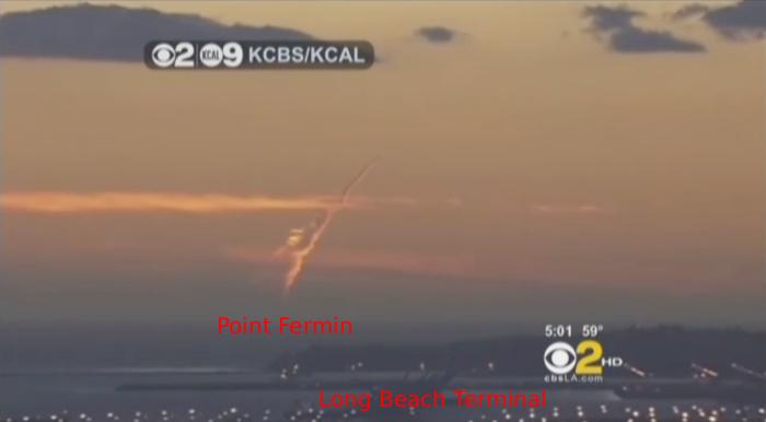
This is the only portion of the video that provides identifiable landmarks: the headland and the Long Beach cargo terminal. This puts the helicopter over land at some point in a line from Point Delfin, over the terminal approximately toward Buena Park. Based on the footage, can anyone dispute this? Look at a map. Nothing photoshopped or secret there:

That points the camera pointing at the plume/contrail out to sea at a heading of SW/WSW. This also puts the field of view slightly to the north of Catalina Island.
With that basic information in the video, aligning Delfin Point and terminal with Google Earth's photo overlay feature allowed me to find a location (along that virtual line) a point that approximates the magnification, tilt and altitude of the helicopter camera. The lights of the terminal area align pretty well with the terminal as laid out in google earth.
Again, there's some margin for error, especially with regards to the actual spot over which the helicopter was at that point in time (less or more magnification moves it closer or farther from the terminal).

For the sake of reproducibility, here are the settings used:

The final image also includes UPS902's track as supplied by FlightAware.com and the FAA.
The UPS MD-11 seen in this film is headed toward Honolulu. It is not traveling at 500 mph toward a spot near the camera, it is headed to a spot approximately 2,500 miles from the camera in a WSW direction. So, there’s only so much lateral movement to be seen from the camera’s position. Plus, the plane is moving to cruise altitude, so it’s probably not even at cruise speed yet, still building steam.
BTW, could you answer these questions?
Do you think that the flight track data showing that UPS 902’s track matches that of the “missile” exactly has been faked? Or do you just believe in coincidence so much that it seems reasonable to expect an SLBM to appear in the exact same spots in the sky where a cargo plane would be onserved?
Were are the sonic boom reports? An SLBM moves through Mach 1 less than a minute after launch.
Why there is no stage separation seen even though China’s SLBMs are two stage and ours are three stage?
If this was a missile, it was a missile especially designed to stay below Mach 1 and hang in the sky for a long time instead of going anywhere a missile would go. No sale.