Posted on 09/02/2009 9:15:35 AM PDT by Ernest_at_the_Beach
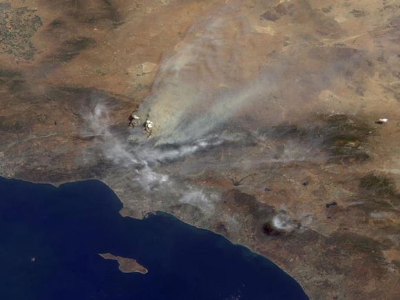
NASA's Terra satellite has captured a dramatic image of the Los Angeles "Station Fire" wildfire. It is one of at least seven conflagrations currently affecting California, which by yesterday had reportedly laid waste to over 133,000 acres and consumed 80 buildings.
NASA explains: "The area covered by the image is 245 kilometers (152 miles) wide. Several pyrocumulus clouds, created by the Station Fire, are visible above the smoke plumes rising from the San Gabriel Mountains north of Los Angeles in the left-center of the image.
"Smoke from the Station Fire is seen covering the interior valleys along the south side of the San Gabriel Mountains, along with parts of the City of Los Angeles and Orange County, and can be seen drifting for hundreds of kilometers to the east over the Mojave Desert."
The Station Fire is described as "the most intense wildfire" the authorities have faced in a decade. It alone has already accounted for 120,000 acres and 70 buildings and continues to menace the hills along the northern edge of Los Angeles. Firefighters say it could take up to two weeks to completely control the blaze. ®
PING
fyi
Wow! Thanks for posting that.
Damn. those fires are puffing out some crud..
For some reason, the smoke from the fire looks like a skull and cross bones. /random
beautiful day, no smog, cannot see any homes - and people say we impact the planet.
Nasa page:
And detail:
*******************************EXCERPT**********************
This image was acquired mid-morning on Aug. 30 by the backward (northward)-viewing camera of the Multi-angle Imaging SpectroRadiometer (MISR) instrument on NASA's Terra satellite.
People say this is “close” to LA, but how close is it really....fringes of the northern suburbs are probably 50 miles from the city center?
I wonder if it is going to burn all the way to the 215.
Damn. those fires are puffing out some crud..””
Yeah- and only last week, the enviro nuts wanted “romantic candle light dinners” banned because they create too much global warming.
Boffins: Give up on CO2 cuts, only geoengineering can work
**********************************EXCERPT****************************
Ordinary eco-efforts a foolish distraction
Top British climate boffins have said that the only practical hope for arresting global warming is the use of "geoengineering" - techniques intended to reduce the effects of CO2 emissions, as opposed to reducing the CO2 emissions themselves.
The scientists add that not only are large emissions cuts politically and diplomatically unfeasible, but that geoengineering would actually be cheaper and easier.
bookmark
Well , out here some say Palm Springs is close to Los Angeles...but it can be several hours driving time to Santa Monica on the ocean Beach.

Well there’s your problem. The whole place is brown for miles around, (no, I don’t mean Mexicans).
Where I live, it’s green. Green stuff doesn’t burn like that.
***************************************
On the night of August 30-31, 2009, the Station Fire north of the city of Los Angeles spread in three directions and doubled in size, according to the Los Angeles Times. Two fire fighters had been killed and at least at least 18 homes in Tujunga Canyon had burned as of the morning of August 31. According to the Incident Information System, the Station Fire covered 85,760 acres as of the morning of August 31, 2009.
The Moderate Resolution Imaging Spectroradiometer (MODIS) on NASA’s Terra satellite captured this true-color image around 11:45 a.m. local time (18:45 UTC) on August 30, 2009. Red outlines indicate hotspots of anomalously high surface temperatures associated with wildfires. In this image, the hotspots remain west of Mt. Wilson. The site of critical communication centers, Mt. Wilson had not burned but was threatened by the fire as of August 31, according to the Los Angeles Times. Smoke from the fire blows toward the northeast in this image. Clouds, perhaps mixed with some smoke, linger over Los Angeles.
NASA image by Jeff Schmaltz, MODIS Rapid Response Team, Goddard Space Flight Center. The Rapid Response Team provides daily images of this area. Caption by Michon Scott.
Looks like a westcoast version of Woodstock.
Disclaimer: Opinions posted on Free Republic are those of the individual posters and do not necessarily represent the opinion of Free Republic or its management. All materials posted herein are protected by copyright law and the exemption for fair use of copyrighted works.