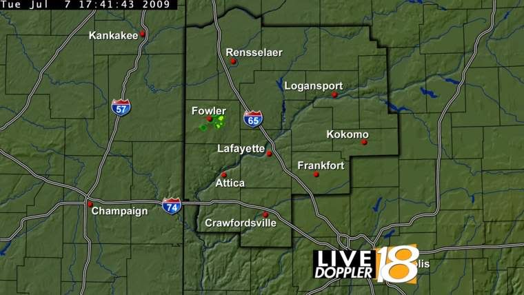
 This is from the WLFI TV18 web site. www.wlfi.com
There are 5 wind farms around KICT (Wichita, KS) that screw with out radar. Very annoying.
Interesting! As a former pilot, this might be a little concerning if we cannot rely in good weather information. Might find cancellations of takeoffs or landing at certain airports because of weather not supported. I’ve been against wind turbines from the start.
What’s a few flash floods or tornados that weren’t picked up among friends. The dead people from those can be happy that they sacrificed their lives for ‘green energy from giant windmills.’
The interference from the Twin Groves Wind Farm east of Bloomington, Illinois seems to exist only when the blades are wet. Seems as though frost & heavy dew will sometimes cause reflections. There is no way for me to observe if the rotation has an effect, but I suspect it does. There is rain moving past just now (6:50 pm) and the farm is visible as stationary green on Weather Underground animated radar.
Thanks for the post..
Marked to read later
From the TV18 weather guy.
http://blogs.wlfi.com/2009/07/01/wind-farms-show-up-on-live-doppler-18/
WIND FARMS SHOW UP ON LIVE DOPPLER 18…………
July 1st, 2009 at 4:16 pm by Chad Evans under Chad’s WLFI Weather Blog
I have had numerous questions recently as to why it seems to always be raining near Fowler, or why there continues to be a red blob over Benton County on Live Doppler 18:
National Weather Service radars & other television station radars are having the same issues as more & more wind farms are built.
There are 3 ways to combat this:
1. Decrease radar sensitivity, so the blob shows up less. However, this would mean that rainfall echoes would not be as detailed & would even be inaccurate. A heavy storm that should show up as red, could be only yellow on the radar. A pink spot indicating large hail might only be red or yellow, if sensitivity is decreased.
2. Tilt the radar beam upward to overshoot the wind farms. The Live Doppler beam is at the correct, standard height & a shift in the beam upward could overshoot any low-topped showers or t’storms near the radar or cause the data to be inaccurate by reflecting rain & hail data well up in the storm, not toward the surface. What is reflected toward the surface is what is likely reaching the ground.
3. Set up an “Exclusion Zone”. This would be built into the radar to basically skip northwest Tippecanoe, Benton & even far southwestern Newton counties so NO data shows up there. However, this would mean that these locations would have no coverage from our Live Doppler. Thus, that would never be a solution.
Obviously, there is no clear-cut remedy for this.
However, we do have a Doppler 18 Network of 4 other radars that are far enough away from that wind farm to prevent this data pollution from occurring.
Thus, I normally compare our data with Live Doppler 18 to our 4 other radars at National Weather Service Offices in Lincoln & Chicago, Illinois & North Webster & Indianapolis, Indiana. With these radars, I am able to determine whether wind farm interference is occurring or an actual t’storm is over central Benton County.
As more wind farms are constructed, potentially more blobs will develop on Live Doppler 18 over the next few years…………stay tuned………….
Here are other cool links that explain this phenomena:
http://www.erh.noaa.gov/buf/windfarm.htm
http://www.watertowndailytimes.com/article/20090624/NEWS03/306249964
FWIW, I note that the NOAA images all are "cranked up" and are showing massive ground clutter. I'd bet that simply turning on ground clutter suppression (subtraction) would reduce the windfarm effect significantly.
Personally, on my bookmarked WUnderground.com radar views, I keep ground clutter suppression "ON". The signals from actual dangerous weather are so strong that they are diminished hardly at all.
The simple act of animating ("looping") the radar displays makes it immediately obvious that the windfarm signals are stationary. As such, they are easy to ignore or discount.
IOW, this is much ado about nothing...
LOL!
So that’s where gobal warming comes from.