To: blam; Fred Nerks; SunkenCiv; All
I think this might be awfully interesting for those not color challenged like myself. Steve Dutch with the Univ of Wis-Green Bay, as he explains
HERE, has taken USGS info and formatted it for the web.
It may shed some light on the present discussion about ARIZONA'S Grand Canyon; I dunno. I think I'm able to pick out the Grand Canyon on the map but since I can't do anything with the colors, it's terribly frustrating. A little help? Or if you find anything else interesting, give a shout.
42 posted on
02/20/2008 9:40:11 PM PST by
ForGod'sSake
(ABCNNBCBS: An enemy at the gates is less formidable, for he is known and carries his banner openly.)
To: ForGod'sSake
Oh boy. To many colors for me.
43 posted on
02/20/2008 9:48:14 PM PST by
blam
(Secure the border and enforce the law)
To: Bernard Marx; Renfield
~PING~ to
#42 for comments/observations.
45 posted on
02/20/2008 10:07:50 PM PST by
ForGod'sSake
(ABCNNBCBS: An enemy at the gates is less formidable, for he is known and carries his banner openly.)
To: ForGod'sSake
The advantage to using graphs in studies is that there are fewer pages to skip. ;’)
46 posted on
02/20/2008 11:24:21 PM PST by
SunkenCiv
(https://secure.freerepublic.com/donate/___________________Profile updated Tuesday, February 19, 2008)
To: ForGod'sSake
47 posted on
02/21/2008 3:22:09 AM PST by
Fred Nerks
(fair dinkum!)
To: ForGod'sSake
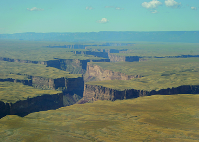
interesting image of Marble Canyon.
49 posted on
02/21/2008 3:35:22 AM PST by
Fred Nerks
(fair dinkum!)
To: ForGod'sSake

Rift Valley in the East Pacific Rise near 13°N, obtained during a dive of the CYANA submersible (CYANA in 1972); courtesy of R. Hekinian.
SOURCE LINK.
50 posted on
02/21/2008 3:49:14 AM PST by
Fred Nerks
(fair dinkum!)
To: ForGod'sSake

A robot submarine is revealing the hidden secrets of a massive underwater canyon off the coast of Portugal. At 5km deep, the Nazare Canyon is the same size as America's Grand Canyon...
51 posted on
02/21/2008 3:58:44 AM PST by
Fred Nerks
(fair dinkum!)
To: ForGod'sSake
That’s a nice site, but it’s just about impossible to do any coherent analysis with state-scale geologic maps. We use 15-minute geologic quads at work (these are at a scale of 1” = 4000’).
53 posted on
02/21/2008 4:43:44 AM PST by
Renfield
(Turning apples into venison since 1999!)
FreeRepublic.com is powered by software copyright 2000-2008 John Robinson