Skip to comments.
La Niña is expected to continue through the Northern Hemisphere spring 2008.
NOAA Climate Prediction Center ^
| 7 February 2008
| Climate Prediction Center Internet Team
Posted on 02/08/2008 3:25:36 AM PST by justa-hairyape
EL NIÑO/SOUTHERN OSCILLATION (ENSO)
DIAGNOSTIC DISCUSSION
issued by
CLIMATE PREDICTION CENTER/NCEP
7 February 2008
Synopsis: La Niña is expected to continue through the Northern Hemisphere spring 2008.
Current atmospheric and oceanic conditions indicate that La Niña has continued to strengthen in
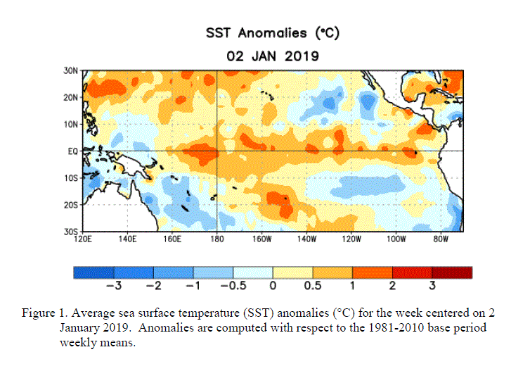
the tropical Pacific. By the end of January 2008, equatorial SST anomalies were more than 2.0°C
below average across parts of the central and east-central equatorial Pacific.

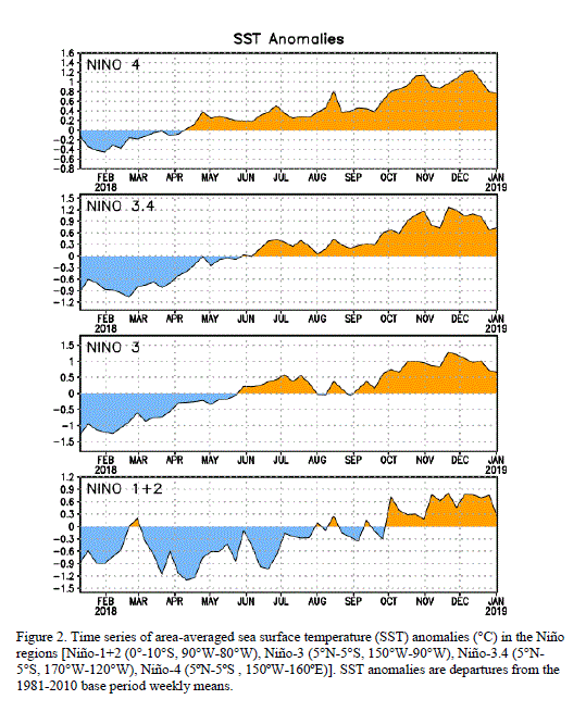
Other than the far eastern Niño-1+2 region, the magnitude of the cold anomalies in the Niño region
indices increased during the past month with the latest weekly values near -1.5°C.

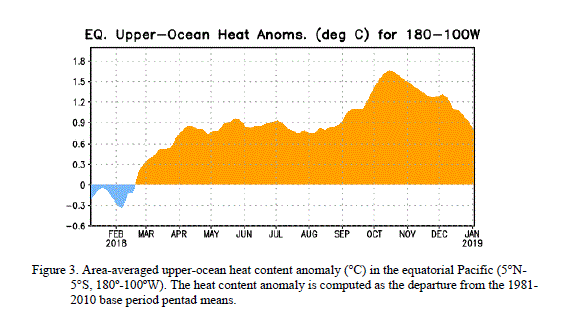
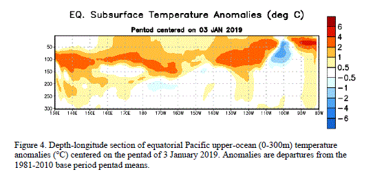
The upper-ocean heat content (average temperatures in the upper 300m of the oceans) also decreased
further during January (figure 3), and negative subsurface anomalies between -2°C to -5°C expanded
westward towards the Date Line (figure 4).


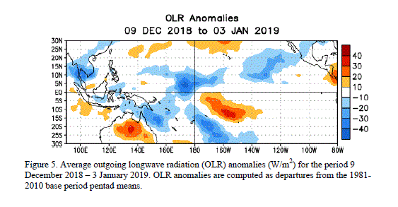
Consistent with these oceanic conditions, stronger-than-average low-level easterly and upper-level
westerly winds persisted across the central equatorial Pacific, convection remained suppressed
throughout the central equatorial Pacific, and enhanced convection covered the far western Pacific.
Collectively, these oceanic and atmospheric conditions are similar to those accompanying the last
strong La Niña episode in 1998-2000.
The recent dynamical and statistical SST forecasts for the Niño 3.4 region indicate a moderate-to-strong
La Niña through the rest of the Northern Hemisphere winter, with the likely continuation of a weaker
La Niña through April-May-June.

Thereafter, there is considerable spread in the models, with approximately one-half indicating La Niña
could continue well into the Northern Hemisphere summer. Current atmospheric and oceanic conditions
and recent trends are consistent with the likely continuation of La Niña through the Northern
Hemisphere spring 2008.
Expected La Niña impacts during February-April include a continuation of above-average precipitation
over Indonesia and below-average precipitation over the central equatorial Pacific. For the contiguous
United States, potential impacts include above-average precipitation in the Northern Rockies, the
Pacific Northwest, and the Ohio and Tennessee Valleys. Below-average precipitation is expected across
the South, particularly in the southeastern states.
This discussion is a consolidated effort of NOAA and its funded institutions. Oceanic and atmospheric
conditions are updated weekly on the Climate Prediction Center web site
(El Niño/La Niña Current Conditions and Expert Discussions).
Forecasts for the evolution of El Niño/La Niña are updated monthly in the Forecast Forum
section of CPC's Climate Diagnostics Bulletin. The next ENSO Diagnostics
Discussion is scheduled for 6 March 2008. To receive an e-mail notification when
the monthly ENSO Diagnostic Discussions are released, please send an e-mail message to:
ncep.list.enso-update@noaa.gov.
Climate Prediction Center
National Centers for Environmental Prediction
NOAA/National Weather Service
Camp Springs, MD 20746-4304
TOPICS: News/Current Events; Technical
KEYWORDS: agw; cold; globalcooling; globalwarming; lanina; noaa; weather
Navigation: use the links below to view more comments.
first previous 1-20, 21-40, 41-60, 61-80, 81-93 next last
To: justa-hairyape
I thought we had La nina last summer. Here in RI it was one of the worst summers I remember. Sprinkled only twice, and every damned day was 85 and sunny. Disgusting.
If I wanted to live in hell I’d move to California.
To: Alas Babylon!
Matches up well with yours. Percent of normal precipitation year to date. Red is 10% of normal.

42
posted on
02/08/2008 8:08:13 AM PST
by
VeniVidiVici
(Benedict Arnold was against the Terrorist Surveillance Program)
To: JustDoItAlways
If La Nina’s historically occur at a certain point in the solar cycle, (typically begin around the low level of activity and continue during the rising solar activity), the current La Nina would mean that we are in the time frame normally considered the increasing solar activity period. If this is true, we are going to have a very weak Solar Cycle 24. Might be lucky to peak at 50 sunspots.
To: the gillman@blacklagoon.com
According to the charts above, La Nina began in March to April and really got going in the Fall to Winter of last year. Due to your location, the Atlantic probably has the greater influence on your temperatures. Apparently, what you want is that the Gulf Stream stops. That would give you some colder summer days.
To: justa-hairyape
To: justa-hairyape
La Nina is a convenient “weather god” used by the climate hoaxers to account for their missing warming. It was created for the same reason that all false gods are created, to account for that which they don’t have an answer for or to conveniently account for something that is inconvenient.
46
posted on
02/08/2008 12:22:42 PM PST
by
Perchant
To: Perchant
Good points. I think the Oscillations basically are the following. After Solar activity has been strong for 4 to 5 years, the Earths Oceans absorb all that extra energy. This then manifests itself as the El Nino (Warming Equatorial Pacific). The El Nino typically shows up as the Solar activity level is dropping due to ocean current lags (the Pacific is immense). After solar activity has been weak for a few years, the heat will have radiated out of the Ocean. The cool Equatorial Pacific then manifests itself as a La Nina. These typically occur during the rising solar activity part of the cycle. My guess would be it takes longer to heat the Equatorial Pacific Ocean, while it is able to radiate the heat quicker. Actually, the El Nino could be considered the radiating phase, not the warming phase. By the time El Nino radiates, the heat radiated will have been absorbed a few years prior. So basically, the La Nina phase needs increasing solar activity to start the warming cycle. So it should not stop until the sun increases its activity.
To: justa-hairyape
I really love thunderstorms and what everyone else calls harsh weather. Hurricanes, tornados, waterspouts, blizzards, howling winds and driving rain.
Reminds me of youth.
Sunshine is boring.
To: justa-hairyape
Just for fun I went and did a google news archive search for "el nino" and found this story from Time Magazine in 1925:
http://www.time.com/time/magazine/article/0,9171,720226,00.html
It's about a town in Ecuador called Santa Elena that is usually very dry and the story is about how El Nino came in and caused rains and flooding which wiped out the area.
So I did a google news ( current news ) search for that town and found an article posted three days ago about the heavy rains, floods and emergency situation that is happening down there at this very moment.
It seems that they need to keep insisting that la nina, not el nino, is happening right now to account for the cold temperatures which are undercutting their global warming hysteria, since back in 1925 they would be calling this a severe El Nino event on the "dry coast" of Ecuador.
49
posted on
02/08/2008 3:12:30 PM PST
by
Perchant
To: justa-hairyape
La Nina does seem to breaking up a little

To: JustDoItAlways
You are referring to the anomaly in the far Eastern pacific along the western coastlines of Central and South America ? How is the Anomaly calculated ? Is it calculating the real time trend of temperature change or is it calculating the degree of change based on past historic norms ?
To: Perchant
It seems that they need to keep insisting that la nina, not el nino, is happening right now to account for the cold temperatures which are undercutting their global warming hysteria, since back in 1925 they would be calling this a severe El Nino event on the "dry coast" of Ecuador. And its not just the fact that they are blaming their errors on an anomaly. What makes it worse is they do not even seem to care what may be causing the anomaly. IE - They know they are wrong and do not care about correcting their mistake. Easier to blame something or someone else. I believe this is diagnosed as projectionism. They are projecting their faults on the poor little El Nino and La Nina.
To: justa-hairyape
A link to an interesting paper was posted on another FreeRepublic thread today.
The Sun Also Sets Here is the paper link. Solar Activity Controls El Niño and La Niña
That author finds significant correlation with El Nino/La Nina periods and solar activity. This correlation is even more significant in the falling and rising area of the Solar Activity curve. IE - The correlation is not strongest with respect to the peak and the bottom parts of the curve. The paper is rather complex and I have just glanced through it at this point in time.
To: justa-hairyape
Also, anyone have any ideas what will happen with an extended La Niña after our historic 2007/2008 winter ?
Pardon my ignorance, but what is historic about this winter? It's seemed pretty uneventful in NC.
54
posted on
02/08/2008 6:26:08 PM PST
by
gitmo
(From now on, ending a sentence with a preposition is something up with which I will not put.)
To: gitmo
Up until the Historic Tornadic outbreak we just had, the southeast was fairly mild. Mainly due to the mild Atlantic. There was one time this winter when the La Nina/Arctic cold managed to penetrate the southeast. What is historic about this winter is the affects of La Nina. There are some lists documenting what has happened, but off the top of my head, here are the following Historic occurrences which seem to be related to the La Nina.
- Recent China Blizzard. Longest lasting in 100 years.
- Snow in Baghdad. First time ever for some old timers.
- Northwest US Blizzards. Numerous single day snow records being set and we are now seeing all time seasonal records being broken.
- Snow occurred in Argentina during their summer.
Those are the main ones I can remember. I am thinking about putting together a list with links, but others will probably get lists together before I get the time (very busy). There are a couple of interesting lists right now. Links below.
Events outside US
This Wikipedia page documents all major storm events this winter. Some of these may have been historic.
Winter Storms of 2007-2008
To: justa-hairyape
To: justa-hairyape
To: justa-hairyape
58
posted on
02/09/2008 9:20:40 AM PST
by
gitmo
(From now on, ending a sentence with a preposition is something up with which I will not put.)
To: JustDoItAlways
Had a chance to analyze the ONI (Oceanic Nino Index) anomaly data at the Climate Prediction Center in a little more detail. At least the past two cycles. There is definitely a correlation between El Nino Oscillations (warming) occurring during the falling solar activity curve and a correlation between La Nina Oscillations (cooling) occurring during the rising solar activity curve. This is a generalization that typically holds true. El Ninos begin at peak or right after the peak of activity and continue until the activity falls to minimum. La Ninas begin at minimum activity or right after and continue up until peak activity is reached. During the rising activity phases, El Ninos come and go. During the falling acitivty phases, La Ninas come and go. There are however exceptions to these general underlying principals. The 1997/1998 El Nino occurred at a time when it should not have. It was also sandwiched between La Ninas. The magnitude of that El Nino was very high and higher then we normally see for what we believe are solar induced Tropical Pacific Oscillations. My guess at this point is that the 1997/1998 El Nino was caused by underwater volcanic activity. The first underwater volcanic eruption was discovered and began in August 1996. The undersea Hawaiian Volcano Loiki erupted on the Hawaiian Pacific hotspot. Then in January of 1997 a warm anomaly occurred at depth in the Pacific and then rose to the surface in April of 1997. Very interesting coincidence. The Pacific hotspot might at times warm the deeper Pacific Ocean waters and could cause El Ninos to appear during rising solar activity phases (normal La Nina period). It is also possible that smaller volcanic activity could be affecting the Pacific anomaly data. We wont know with certainty until these underwater eruptions are monitored more precisely. Other researchers have proposed links between underwater volcanic activity and Ocean temps in the past.
To: justa-hairyape
Anyone want to bet that the warming anomaly occurring in the polar north which appears in the monthly anomaly images above from June to November 2007, was due to underwater volcanic activity ?
Navigation: use the links below to view more comments.
first previous 1-20, 21-40, 41-60, 61-80, 81-93 next last
Disclaimer:
Opinions posted on Free Republic are those of the individual
posters and do not necessarily represent the opinion of Free Republic or its
management. All materials posted herein are protected by copyright law and the
exemption for fair use of copyrighted works.
FreeRepublic.com is powered by software copyright 2000-2008 John Robinson
