Skip to comments.
La Niña is expected to continue through the Northern Hemisphere spring 2008.
NOAA Climate Prediction Center ^
| 7 February 2008
| Climate Prediction Center Internet Team
Posted on 02/08/2008 3:25:36 AM PST by justa-hairyape
EL NIÑO/SOUTHERN OSCILLATION (ENSO)
DIAGNOSTIC DISCUSSION
issued by
CLIMATE PREDICTION CENTER/NCEP
7 February 2008
Synopsis: La Niña is expected to continue through the Northern Hemisphere spring 2008.
Current atmospheric and oceanic conditions indicate that La Niña has continued to strengthen in
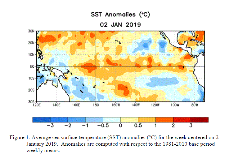
the tropical Pacific. By the end of January 2008, equatorial SST anomalies were more than 2.0°C
below average across parts of the central and east-central equatorial Pacific.

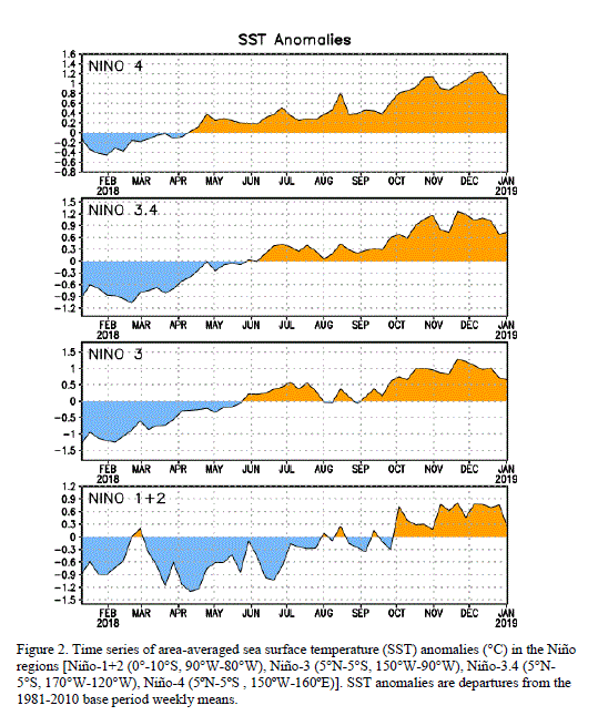
Other than the far eastern Niño-1+2 region, the magnitude of the cold anomalies in the Niño region
indices increased during the past month with the latest weekly values near -1.5°C.

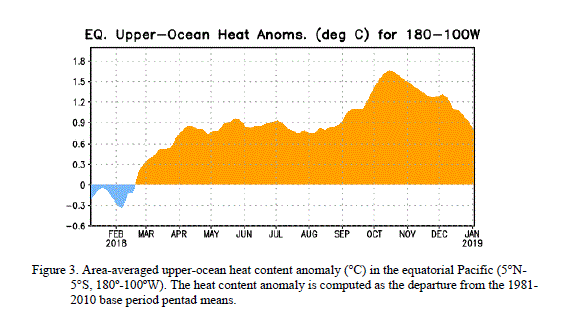
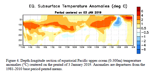
The upper-ocean heat content (average temperatures in the upper 300m of the oceans) also decreased
further during January (figure 3), and negative subsurface anomalies between -2°C to -5°C expanded
westward towards the Date Line (figure 4).


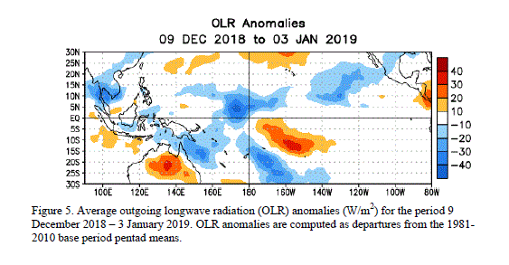
Consistent with these oceanic conditions, stronger-than-average low-level easterly and upper-level
westerly winds persisted across the central equatorial Pacific, convection remained suppressed
throughout the central equatorial Pacific, and enhanced convection covered the far western Pacific.
Collectively, these oceanic and atmospheric conditions are similar to those accompanying the last
strong La Niña episode in 1998-2000.
The recent dynamical and statistical SST forecasts for the Niño 3.4 region indicate a moderate-to-strong
La Niña through the rest of the Northern Hemisphere winter, with the likely continuation of a weaker
La Niña through April-May-June.

Thereafter, there is considerable spread in the models, with approximately one-half indicating La Niña
could continue well into the Northern Hemisphere summer. Current atmospheric and oceanic conditions
and recent trends are consistent with the likely continuation of La Niña through the Northern
Hemisphere spring 2008.
Expected La Niña impacts during February-April include a continuation of above-average precipitation
over Indonesia and below-average precipitation over the central equatorial Pacific. For the contiguous
United States, potential impacts include above-average precipitation in the Northern Rockies, the
Pacific Northwest, and the Ohio and Tennessee Valleys. Below-average precipitation is expected across
the South, particularly in the southeastern states.
This discussion is a consolidated effort of NOAA and its funded institutions. Oceanic and atmospheric
conditions are updated weekly on the Climate Prediction Center web site
(El Niño/La Niña Current Conditions and Expert Discussions).
Forecasts for the evolution of El Niño/La Niña are updated monthly in the Forecast Forum
section of CPC's Climate Diagnostics Bulletin. The next ENSO Diagnostics
Discussion is scheduled for 6 March 2008. To receive an e-mail notification when
the monthly ENSO Diagnostic Discussions are released, please send an e-mail message to:
ncep.list.enso-update@noaa.gov.
Climate Prediction Center
National Centers for Environmental Prediction
NOAA/National Weather Service
Camp Springs, MD 20746-4304
TOPICS: News/Current Events; Technical
KEYWORDS: agw; cold; globalcooling; globalwarming; lanina; noaa; weather
Navigation: use the links below to view more comments.
first previous 1-20, 21-40, 41-60, 61-80, 81-93 next last
To: justa-hairyape
The Sun has recently entered the up phase of the next Sunspot Cycle. This may be good for weather and it is much appreciated by us Hams.
LLS
21
posted on
02/08/2008 4:40:09 AM PST
by
LibLieSlayer
("There is no conservative alternative in the race. It's just that simple." Rush Limbaugh)
To: justa-hairyape
Last January, the NOAA predicted just a 1% chance of a La Nina developing and they predicted that El Nino conditions would continue. A measly 1%.
10 days later, the El Nino pattern flipped off and we went straight into a La Nina pattern. Global temperatures started declining on January 15th, 2007 and have declined by 0.6C over the past year.
The NOAA cannot forecast the ENSO. Nobody seems to able to.
To: justa-hairyape
For what it's worth, here are some of the effects on Northern Hemisphere winds, temp and precip associated with La Niña vs El Niño years.

23
posted on
02/08/2008 4:48:20 AM PST
by
billorites
(Freepo ergo sum)
To: justa-hairyape
Regarding your sunspot chart, Galileo got his ass handed to him for posting that.
24
posted on
02/08/2008 4:50:09 AM PST
by
billorites
(Freepo ergo sum)
To: Bulwinkle
Thanks for the links. Just took a quick look and perhaps the same anecdotal observations that were just discussed on this thread, also find some correlation in the recent data in your first link. Generally -
La Nina tends to occur during the rising part of the solar sunspot cycle (more relevantly stated as after the level of solar activity has fallen).
El Nino tends to occur during the falling part of the solar sunspot cycle (more relevantly stated as after the level of solar activity has risen).
If that is true, perhaps what is happening is normal for recent solar sunspot cycles. I guess all will depend on the strength of solar cycles 24 and 25.
To: billorites
Galileo got his ass handed to him for posting that. Yeah, but in hindsight he probably still would have done it. You only live once.
To: billorites
Thanks for the charts. The Southwest was not supposed to get the rain we got last month. Current long term weather predictions are that late February the Jet Stream will move south and the Southwest will get nailed again. Currently a typical La Nina is occurring and nailing the Northwest.
To: justa-hairyape
Thanks for the posts. Will check the thread out later today. Have fun !
To: justa-hairyape
29
posted on
02/08/2008 5:07:23 AM PST
by
Brad from Tennessee
("A politician can't give you anything he hasn't first stolen from you.")
To: justa-hairyape
Well, it's just one of the overall symptoms of Global Climate Change, you see.
See how easy it is to explain it?
30
posted on
02/08/2008 5:19:40 AM PST
by
OKSooner
To: ExGeeEye
New Years day 1963, South Mississippi had 16 inches of snow! I was 11, it was great! 1961-1965 were bitterly cold. Ponds froze, temps dropped to single digits, the old folks could not recall it ever being so cold. Most blamed it on testing of nukes in the South Pacific. Health officials actually cautioned us NOT to make snow ice cream because of the potential of radioactivity.
31
posted on
02/08/2008 5:20:55 AM PST
by
Islander7
("Show me an honest politician and I will show you a case of mistaken identity.")
To: justa-hairyape
Thank you :)
As for 1998: I was under the imression that NASA (?) had revised the measured temperature peak to 1934 due to flaws in the measurement method (thermometer placement?)
1934 is still “off” given my amateur modeling— should be 1927? with the previous cold low bing in 1910 (which fits my anecdotal profile— snw in Mexico or somesuch IIRC).
32
posted on
02/08/2008 5:30:25 AM PST
by
ExGeeEye
(NIE or no NIE, I've been waiting since 11/04/79 to do something about Iran.)
To: Islander7
Interesting. Just goes to show you.
My methodology is positively pre-midieval.
33
posted on
02/08/2008 5:34:37 AM PST
by
ExGeeEye
(NIE or no NIE, I've been waiting since 11/04/79 to do something about Iran.)
To: LibLieSlayer
-—”The Sun has recently entered the up phase of the next Sunspot Cycle.”
I’m not sure cycle 24 has started[I’m not a scientist]....I did see the announcement:
“On January 4, 2008, a reversed-polarity sunspot appeared—and this signals the start of Solar Cycle 24,” says David Hathaway of the Marshall Space Flight Center.
http://science.nasa.gov/headlines/y2008/10jan_solarcycle24.htm
BUT, back in the summer of 2006 they said the same thing!!!...
On July 31st [2006], a tiny sunspot was born. It popped up from the sun’s interior, floated around a bit, and vanished again in a few hours. On the sun this sort of thing happens all the time and, ordinarily, it wouldn’t be worth mentioning. But this sunspot was special: It was backward.
“We’ve been waiting for this,” says David Hathaway, a solar physicist at the Marshall Space Flight in Huntsville, Alabama. “A backward sunspot is a sign that the next solar cycle is beginning.”
http://science.nasa.gov/headlines/y2006/15aug_backwards.htm
If you look at this graph you will see little sunspot activity since the Jan. 3 announcement...
http://www.dxlc.com/solar/
To: justa-hairyape
Well, it means here in Alabama we're goning to continue to experience this:

To: justa-hairyape
Mat 16:2
He answered and said unto them, When it is evening, ye say, [It will be] fair weather: for the sky is red.
Mat 16:3
And in the morning, [It will be] foul weather to day: for the sky is red and lowring. O [ye] hypocrites, ye can discern the face of the sky; but can ye not [discern] the signs of the times?
36
posted on
02/08/2008 5:42:04 AM PST
by
ATOMIC_PUNK
(Drink no longer water, but use a little wine for thy stomach's sake and thine often infirmities.)
To: Bulwinkle
Solar Cycle 24 starts when there are more Cycle 24 sunspots (with reversed magnetic polarity) than there are Cycle 23 sunspots. The Cycle 24 sunspots will also appear at higher latititudes (above 30 degrees N and S).
So far there has only been 2 Cycle 24 sunspots (1 high latitude and 1 at the equator) while there has been about 20 Cycle 23 sunspots so the official switch has not happened yet. Probably soon though.
To: justa-hairyape
38
posted on
02/08/2008 6:26:40 AM PST
by
piroque
To: Bulwinkle
I have seen the definitive data... and 21 and 28Mhz are showing some propagation improvement due to slightly better ionization of the E layer.
LLS
39
posted on
02/08/2008 6:31:12 AM PST
by
LibLieSlayer
("There is no conservative alternative in the race. It's just that simple." Rush Limbaugh)
To: justa-hairyape
It has been a very tough Winter here in the West. Snoqualmie Pass has a 157” base of snow this morning. Normal is 71”. The story below says 10 feet, which is a major understament. Some areas has 20 feet with 30 foot drifts.
Record Cascade snow could mean extreme spring avalanche danger
MOUNT PILCHUCK, Wash. — Experts are warning that record snowfall this season has built up the potential for huge spring avalanches with the power to cause extensive damage to mountain hillsides, roads and bridges.
Nearly 10 feet of winter snow has accumulated already in parts of the Cascades, including near Stevens Pass. If a massive slab of snow were to break off — and conditions are in place for this type of avalanche to occur — it could ravage the landscape, destroying timber stands, homes, roads and whatever else is in the avalanche’s path.
“There’s the potential for something really big,” said Mark Moore, director of the Northwest Weather and Avalanche Center.
This winter already is the worst avalanche season in Washington in modern history. Since December, three Snohomish County residents are among the nine people from Washington who have died in avalanches.
Now, officials fear the death toll could rise and the potential for other damage from rushing walls of snow is high.
http://www.usatoday.com/weather/news/2008-01-22-cascade-avalanche_N.htm
Navigation: use the links below to view more comments.
first previous 1-20, 21-40, 41-60, 61-80, 81-93 next last
Disclaimer:
Opinions posted on Free Republic are those of the individual
posters and do not necessarily represent the opinion of Free Republic or its
management. All materials posted herein are protected by copyright law and the
exemption for fair use of copyrighted works.
FreeRepublic.com is powered by software copyright 2000-2008 John Robinson
