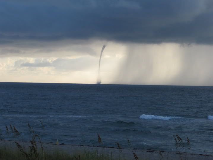
Not my picture.
Posted on 08/28/2006 7:27:21 AM PDT by NautiNurse
Florida Governor Jeb Bush ordered a state of emergency in advance of Ernesto's anticipated Florida landfall as a hurricane. During his press briefing, Governor Bush emphasized the need to, "Have your family plan in place. Be prepared to be on your own for 72 hours. I know it sounds like a broken record." Jeb then repeated his message in Spanish.
All of the South Florida peninsula and Keys are under a hurricane watch, and portions of the watch areas may be upgraded to hurricane warnings later today.
NASA is moving Space Shuttle Atlantis from the launch pad back to its protective hangar, with the launch postponed until at least Sept. 7-8.
Hurricane Ernesto was downgraded to Tropical Storm status after battering Haiti and the Dominican Republic all day Sunday. The death toll in Haiti from Ernesto currently stands at 1 person; storm reports from Hispaniola are scarce this morning.
Ernesto has approached the eastern portion of Cuba, where the government issued a hurricane warning for six provinces, tourists were evacuated, and baseball games were played earlier Sunday than originally scheduled.
Public Advisories Updated every three hours.
Tropical Storm Discussion Updated every six hours
Ernesto Storm Track Archive Nice animated progression of 3 & 5 day forecast tracks
Buoy Data Florida & Eastern GOM
Satellite Images
Additional Resources:
Central Florida Hurricane Center
Hurricane City
| Category | Wind Speed | Barometric Pressure | Storm Surge | Damage Potential |
|---|---|---|---|---|
| Tropical Depression |
< 39 mph < 34 kts |
Minimal | ||
| Tropical Storm |
39 - 73 mph 34 - 63 kts |
Minimal | ||
| Hurricane 1 (Weak) |
74 - 95 mph 64 - 82 kts |
28.94" or more 980.02 mb or more |
4.0' - 5.0' 1.2 m - 1.5 m |
Minimal damage to vegetation |
| Hurricane 2 (Moderate) |
96 - 110 mph 83 - 95 kts |
28.50" - 28.93" 965.12 mb - 979.68 mb |
6.0' - 8.0' 1.8 m - 2.4 m |
Moderate damage to houses |
| Hurricane 3 (Strong) |
111 - 130 mph 96 - 112 kts |
27.91" - 28.49" 945.14 mb - 964.78 mb |
9.0' - 12.0' 2.7 m - 3.7 m |
Extensive damage to small buildings |
| Hurricane 4 (Very strong) |
131 - 155 mph 113 - 135 kts |
27.17" - 27.90" 920.08 mb - 944.80 mb |
13.0' - 18.0' 3.9 m - 5.5 m |
Extreme structural damage |
| Hurricane 5 (Devastating) |
Greater than 155 mph Greater than 135 kts |
Less than 27.17" Less than 920.08 mb |
Greater than 18.0' Greater than 5.5m |
Catastrophic building failures possible |
Tropical Storm Ernesto I
Hurricane Ernesto
oh man that one is heading right for DC. arrrggghh!

Not my picture.
I'm going to watch Prison Break and relax for a bit.


I got to see it a little and this ol' puter had to have a Window-Wash,,,
The office I work in is in Lakeland - the Jupiter office is one of our branches. So I get to go to work tomorrow anyway.
On the current track, Ernesto makes its closest approach to Lakeland sometime Wednesday afternoon. I expect the managers will keep a sharp eye on it tomorrow, and make a decision in the afternoon about whether we open for business on Wednesday.
what this now, its going to hop back into the water after skirting florida and hit south carolina as a cat 1?

some say CAT2...
That's what I was looking at earlier,,South of Cuba ???
Is it being pushed from behind and pulled by the rotation in the Western Gulf ??? or ???
Right now it seems to be bumping into the ridge still over the southeast U.S. The ridge has clockwise rotation, so it pushes things to the west that are south of it. There is a trough of low pressure moving across the U.S. right now that should displace it, and allow the storm to resume a more northerly course, but the way things have been going...
Considering that a yesterday morning it was forecast to hit Tampa from the Gulf side as a Cat 3, I wouldn't worry about the forecast that far out quite yet.
But we have narrowed down what country it's going to hit next.... haven't we? ;-}
That model appears to have a smidgen. But that's just one model of a bunch;)
Good Point,,,I still wonder how far West and how far North
The Whole System is moving ?? Considering the Conditions ?
That's a definite waterspout .. good pic. Did it break up?
"Considering that a yesterday morning it was forecast to hit Tampa from the Gulf side as a Cat 3"
Quite a difference, wasn't it?
It could still go in the Gulf,,,maybe ?
We have arrived, baby! Dat White House ain't gonna be "white" much longer! Right on!;))
Interesting animated Skeetobite track .. hit play
http://flhurricane.com/sbanimator.php?year=2006&storm=5
Disclaimer: Opinions posted on Free Republic are those of the individual posters and do not necessarily represent the opinion of Free Republic or its management. All materials posted herein are protected by copyright law and the exemption for fair use of copyrighted works.