...Rita moves farther inland...weakens to a category two
hurricane...
At 7 am CDT...1200z...the Hurricane Warning west of High Island
Texas has been discontinued.
A Hurricane Warning remains in effect from High Island to Morgan
City Louisiana.
A Tropical Storm Warning remains in effect for the southeastern
coast of Louisiana east of Morgan City to the mouth of the Pearl
River...including metropolitan New Orleans and Lake Pontchartrain
...And from south of Sargent Texas to Port O'Connor Texas.
For storm information specific to your area...including possible
inland watches and warnings...please monitor products issued
by your local weather office.
At 7 am CDT...1200z...the center of Hurricane Rita was located near
latitude 30.4 north...longitude  94.2 West....Midway between Jasper
and Beaumont Texas.
Rita is moving toward the northwest near 12 mph.  A gradual turn
toward the north and a decrease in forward motion is expected
during the next 24 hours.  This motion should bring the center of
Rita farther inland over southeastern Texas today.
Maximum sustained winds have decreased to near 100 mph...with higher
gusts.  This makes Rita a category two hurricane on the
Saffir-Simpson scale.  Additional weakening is expected today as
the center moves farther inland.
Hurricane force winds extend outward up to  85 miles from the
center...and tropical storm force winds extend outward up
to 205 miles.  A ham radio report indicates that Jasper Texas
measured a wind gust to 85 mph recently.
Estimated minimum central pressure is 950 mb...28.05 inches.
Coastal storm surge flooding of 15 feet above normal tide levels...
locally up to 20 feet at head of bays and nearby rivers...with
large and dangerous battering waves...were probably experienced
to the east of where the center made landfall. The coastal storm
flooding should begin to slowly subside today.  Tides along the
southeast Louisiana and Mississippi coasts in areas affected by
Katrina could be 4 to 6 feet above normal and be accompanied by
large waves... and residents there are experiencing coastal
flooding.  Large swells generated by Rita will likely continue to
affect most portions of the Gulf Coast.
Since Rita is movingly slowly and is forecast to slow down further
over the next few days...rainfall totals of 10 to 15 inches are
expected over eastern Texas and western Louisiana.  Maximum
rainfall totals in excess of 25 inches may occur over localized
areas.  Rainfall amounts of 3 to 5 inches with isolated heavier
amounts are possible over southeastern Louisiana including
metropolitan New Orleans.
Isolated tornadoes are possible today and tonight over far eastern
Texas...Louisiana...southern Arkansas...and Mississippi.
Repeating the 7 am CDT position...30.4 N... 94.2 W.  Movement
toward...northwest near 12 mph.  Maximum sustained winds...100 mph.
Minimum central pressure... 950 mb.
The next advisory will be issued by the National Hurricane Center at
10 am CDT.
Forecaster Avila
BTW, I haven't seen much discussion in how well he Mississipi basin will handle the deluge, and will NO catch any flooding from that direction?
Mornin.
The old 1700 Thur graphic is still up at
http://i4.photobucket.com/albums/y138/jeffers_mz/02J.jpg
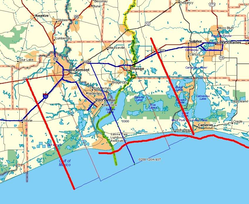
It's a little dated but I have a newer one, zoomed on Orange, Beaumont, and Port Arthur, at:
http://i4.photobucket.com/albums/y138/jeffers_mz/Rita/o4landfallmap.jpg
It's quick and dirty, no legends, but based on the last pre and first post storm plots so it's accurate.
Heavy straight red = outer eyewall boundaries
skinny straight red =inner eyewalls
Heavy wavy red = max surge effect
blue = the linear interpolated eyecenter track
I'm pulling down DEMs right now, looking to have surge projections at 15 and 20 feet for Beaumont, Port Arthur, Orange, and Lake Charles, ETA two hours. Maybe less, many areas don't have 10 meter data so the downloads are going faster.