| This thread has been locked, it will not receive new replies. |
|
Locked on 09/21/2005 4:38:48 PM PDT by Admin Moderator, reason:
Locked - New Thread http://www.freerepublic.com/focus/f-news/1488924/posts |
Posted on 09/21/2005 1:36:24 AM PDT by NautiNurse
Copy that! :-)
We have tens of thousands showing up for a pro troops weekend. I don't want Cindy to get coverage, but I'd hate for us to lose it too.
Austin City Limits is filming in Austin this weekend, so even before Rita, hotel rooms there were hard to come by. We're headed there, but staying with friends.
The 1900 Galveston hurricane hit as a Cat 4, but I don't know if it ever got up to 5.
None.
Hahahahahahahahahahahahahahahahahahahah.... I'm sorry, but that's really funny. Under normal conditions that's a perfectly reasonable thing to say but LOOK at that monster. It isn't going to give anybody a nice soaking anything.
Just announced: Fort Bend County ISD has canceled classes for Thursday and Friday
I believe they fall in the "nuisance" category...no bag limit.
I don't think so...yet. The buzz saw look is what an annular hurricane looks like. Hurricane Katrina was an annular hurricane. Hurricane Rita doesn't look like an annular hurricane yet (because it has definite up and down outflow bands), but it is definitely becoming more symmetric.
Maybe they could be relocated onto Galveston Island for a hurricane party?!
Thanks. Found the surge map.
http://www.kfdm.com/hurricane_surgemap.shtml
Also found a great website with tons of info.
Golden Triangle Weather Page
http://www.ih2000.net/ira/bmt-wth.htm
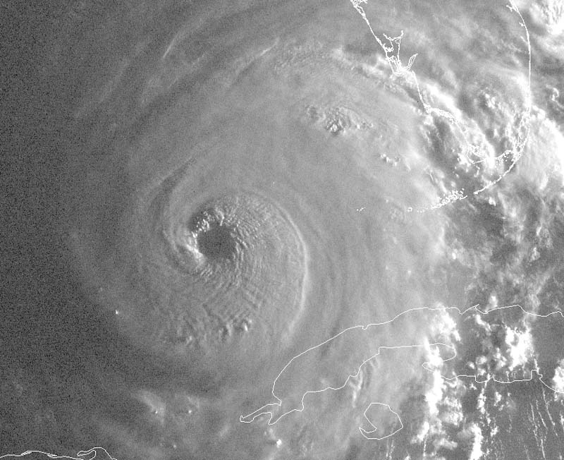
Have you seen this pic?
http://www.usawx.com/morningvisible745amritasept21y.jpg
WOW!
That's true. Mississippi bore the brunt of the wind/storm surge damage.
For a look at what that was, take a look at the link below. Click on any of the boxes and a new page will appear with a number of smaller boxes. Clicking on any of those displays "after" aerial photos. The Mississippi coast was devastated:
Look at Missisipi....
Complete structural failure of buildings 40-50 miles inland.....
Houston is only 40-50 miles inland from Galveston....Rita will be bigger/powerful than Katrina......
NeverGore :^(
I don't know...but their not in Houston any longer...they took flights throughout the country...most went to Arkansas. Some griping their heads off about being an evacuee again...others were pretty civil...I thought what thankless bunch of people. There getting a free flight by a commerical airline at the governments expense [taypayer]...LOL..
For quite a few years now here in Houston we've been knowing we're over due for a hurricane. Our average has been one every 8 years or so, not necessarily a bad one, but a hurricane in the neighborhood. Why did it have to be a storm of the century??? Why did there have to be poetic justice?
(Of course let us all remember the words of Algore: This is but the first sip, the first taste of the bitter cup that is being proffered to us by climate change which THIS administration has ignored by failing to sign the Kyoto accords.)
I've been picturing what I'd be doing if I had to clean up the place and I'd consider hooking up fire hoses to hydrants and just washing everything down to the pumps. A good rain might do the same thing. Or at least get a good start on the parts that are now above water.
have they identified exactly what caused the levees to break? I thought storm surge had a lot to do with it.
Disclaimer: Opinions posted on Free Republic are those of the individual posters and do not necessarily represent the opinion of Free Republic or its management. All materials posted herein are protected by copyright law and the exemption for fair use of copyrighted works.