To: Robert A. Cook, PE
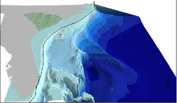
Here's a better NOAA graphic:
A 3-D representation of ocean topography off the southeast portion of the United States. Image courtesy of Phil Weinbach.
49 posted on
05/20/2005 7:59:22 AM PDT by
COBOL2Java
(If this isn't the End Times it certainly is a reasonable facsimile...)
To: COBOL2Java
63 posted on
05/20/2005 8:12:05 AM PDT by
null and void
(Coffee! Because you'll have plenty of time to sleep when you're dead...)
To: COBOL2Java; Robert A. Cook, PE
NEAT GRAPHIC!
I'm trying to picture where more than 6000 ft of water occurs 60 miles off the NC coast. It must be the northeast part close to Virginia - off the Outer Banks, probably? Or does the shelf drop to that level closer to the southern portion of the state?
Really, I didn't know the water was THAT deep that close.
69 posted on
05/20/2005 8:21:29 AM PDT by
azhenfud
("He who is always looking up seldom finds others' lost change...")
To: COBOL2Java
That is a really neat picture. Do you have more? Thanks.
87 posted on
05/20/2005 9:37:15 AM PDT by
xzins
(Retired Army Chaplain and Proud of It!)
FreeRepublic.com is powered by software copyright 2000-2008 John Robinson