We can use natural science to determine a natural pattern from an intelligently designed pattern! ID is a useful science!
Give us an example of where this has been done, when you don't know the history of the object.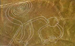
Nazca

Geographic Information Systems
Some 35,000 years ago, Cro-Magnon hunters drew pictures of the animals they hunted on the walls of caves near Lascaux, France, (fig. 1). Associated with the animal drawings are track lines and tallies thought to depict migration routes. These early records followed the two-element structure of modern geographic information systems (GIS): a graphic file linked to an attribute database.
I agree that these appear to be produced by humans, but I would be curious why you think you don't know the history. I think if you saw any painting or depiction you would infer a history. But there are cases where you might be wrong. There are certainly natural phenomena that resemble carved figures. There are certainly objects that are argued about.
What is the objective method used to make the determination?