"I still can not find out anything about our base in Deigo Garcia (just off the tip of India)."
I have been wondering the same thing since I read about the tsumanis. I believe Diego Garcia would be somewhat South of the Maldives(they were hit)....just below the equator.
I spent some time there in 1974 while in the USN. Then the highest point above sea level was proably less than 20 feet. It is just a U shaped coral atol. If a tidal wave hit it, it would deluge the entire atoll.
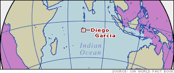
Diego Garcia, British Indian Ocean Territory is located at 7 Degrees South Latitude, off the tip of India. Diego Garcia is exclusively a military reservation located on a small host country atoll in the Chagos Archipelago. The heavily vegetated island has an area of 6,720 acres. The average elevation is four feet above sea level. The maximum elevation is 22 feet. This island is horseshoe shaped with a perimeter of approximately 40 miles. The enclosed lagoon is 6 1/2 miles wide and 13 miles long.
Diego Garcia is a living coral atoll, the coral reefs and island are made up of trillions of living organisms. Once an ancient volcano, all that is left is the atoll surrounding a central lagoon. Thanks to its tropical location and heavy rainfall, the island is heavily vegetated with coconut palm and ironwood trees.
From the air, Diego Garcia takes on the rough outline of a footprint on the ocean surface -- thus its nickname "Footprint of Freedom". The island stretches 15 miles, north to south, and about 35 miles from tip to tip of its horseshoe shape. The interior lagoon is 13 miles in length and 6.5 miles at its widest point. The island has an area of 6,720 acres (roughly 10.5 square miles) with an average natural elevation of four feet above sea level. Lagoon depths vary from 60 to 100 feet with coral heads in all areas.
I was looking at a map of DG and it seems the base itself and the housing is on the western side of the atoll ring. The tsunami would have come from the east. Perhaps it was broken up or deflected by the east side of the Atoll and the lagoon.