Free Republic
Browse · Search
News/Activism
Topics · Post Article

To: liberallarry

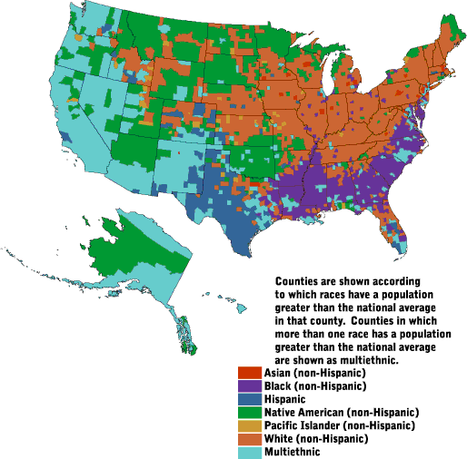
I'd be interested in seeing a black population density map. Since this demographic goes democratic 95% to 5% and is pretty sizable, I would imagine that it would almost mirror the Bush-Kerry county map 100%.


95 posted on 11/08/2004 11:55:02 PM PST by JeffAtlanta
[ Post Reply | Private Reply | To 1 | View Replies ]


To: JeffAtlanta

97 posted on 11/09/2004 7:24:03 AM PST by liberallarry
[ Post Reply | Private Reply | To 95 | View Replies ]

To: JeffAtlanta
Not much of a correlation, probably because blacks constitute too small a percentage of the population...and perhaps because their districts have been gerrymandered.

The maps clearly show that George Bush was elected by white Mormons and white Protestant Evangelicals living in the rural and suburban areas of what was formerly the Confederacy and associated slave-tolerating territories.

98 posted on 11/09/2004 7:33:23 AM PST by liberallarry
[ Post Reply | Private Reply | To 95 | View Replies ]

To: JeffAtlanta
Not much of a correlation, probably because blacks constitute too small a percentage of the population...and perhaps because their districts have been gerrymandered.

The maps clearly show that George Bush was elected by white Mormons and white Protestant Evangelicals living in the rural and suburban areas of what was formerly the Confederacy and associated slave-tolerating territories.

99 posted on 11/09/2004 7:33:47 AM PST by liberallarry
[ Post Reply | Private Reply | To 95 | View Replies ]

Free Republic
Browse · Search
News/Activism
Topics · Post Article


FreeRepublic, LLC, PO BOX 9771, FRESNO, CA 93794
FreeRepublic.com is powered by software copyright 2000-2008 John Robinson