Here you go, capitan.
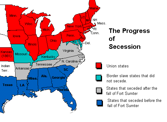
Notice that there are three types of states on the map:
The seceded states (both before and after sumter)
The border states
The union states
Out of all the union states, there are only four that voted for Bush: Ohio, Indiana, Iowa, and Kansas.
Do you comprehend now or are you going to respond with more word games and obfuscation?
Thank you for graphically displaying an example of your tunnel vision. Let's go back to what the original post says:
Always Right - "My history books said the south lost the Civil War, but apparently that was just a battle. The south lost the battle of 1861-1865, but now are winning the war. Excuse the map, I could not find one that had all the states colored in."
Clearly, the intent of the poster was to draw an association between the "red" states of the old South and the other "red" states of the of the West, Rockies, and Plains. This provides the context of my statements, and is the point you have completely missed. All of the territory occupied by the "lower 48" was within the jurisdiction of the United States in 1861. (We can ignore Alaska and Hawaii for the purpose of this discussion.) The CSA (aka "South," as in the "the south lost") was comprised of the 11 so-called seceded states. You may want to also claim Kentucky, Missouri, and the territory now occupied by Arizona and New Mexico, but the fact of the matter is the confederacy never maintained actual control of these areas.
Neither was the "Union" confined to the states you show in your graphic. It included the Pacific Coast states and territories, as well as the area in between. All Union, all garrisoned by Union and loyal militia troops during the War, and all contributors to the Union cause.
You attempt to make a narrow point about the relationship of the old south and the Bush victory, and fail to consider the importance of the other "red" state areas which were organized later into full-fledged states.