Posted on 05/29/2014 5:01:13 AM PDT by Uncle Chip
Danny Owen
2014/06/19 AT 17:08
I am sorry, and with all due respect to Duncan and the entire team, I do not believe the plane came down that far south into the Indian ocean. The final statement is very disappointing.
It does not make sense, from a terrorist or even a human ideology point of view.
Unless, unless the cargo on the plane was deemed so sensitive, so secretive that the plane was hijacked simply to have the cargo destroyed and never to be found again, should it fall into the wrong hands.
Why hijack the plane? Why take it that far south? Perhaps your calculations were based on the ‘possibility’ that a similar plane as MH370 can fly that far south? Perhaps the data released is simply a ruse to keep us all away from the most likely location of the plane – closer to Malaysia?
Reply from Duncan Steel
2014/06/19 AT 17:45
Perhaps you have missed the point that the working hypothesis, broadly, is that the autopilot – in the absence of any human input – flew the aircraft to its terminal point.
And you also seem to have missed the point that the intent of this blog has been use of the evidence that is available, and not things that people “believe” or not. People’s beliefs are not evidence.
[Hey Duncan — what is the difference between a “working hypothesis” and a “belief” and where is your evidence that your “working hypothesis” is not just a “belief” —
Your autopilot has the plane travelling 100mph faster than Inmarsat’s autopilot and touching down 700 miles away from each other — So then which autopilot was in control of the plane? — yours or Inmarsat’s — and which hypothesis was working at the time of the touchdown? — yours or Inmarsat’s]
Bruce Lamon
2014/06/19 AT 17:15
Inmarsat seems to me to have made three of the top four mistakes which have significantly impeded the search:
1) failing to account for the location of the satellite,
2) failing to account for the location of the ground station and
3) endorsing the search in the area of the acoustic pings.
(The fourth and most important being Malaysia’s failure to scramble aircraft.) A little transparency early on may have saved a lot time, money and agony. Plus I suspect early transparency would have been a lot less embarrassing than the obfuscation will be when history of the search is finally written.
I infer that release of the model would show that Inmarsat was misleading us then or is misleading us now.
There fixed it --
Malaysian police investigation names MH370 pilot ‘prime suspect’
After conducting 170 interviews, investigators noted strange behaviour by the pilot. He had made no future plans - socially or professionally - and his home flight simulator was programmed with a flight path into the depths of the Southern Ocean before landing the plane on an island with a small runway. The drills were deleted from the computer but specialists were able to retrieve the files. There is also speculation his home life was fraught with difficulties, though this has been denied by his family.
Well Duhh
Could that island with a small runway have been Christmas Island just south of Bandung Indonesia???
or New Amsterdam:
http://en.wikipedia.org/wiki/%C3%8Ele_Amsterdam
Location: S37.84E77.55
3349 miles from the estimated point of turn south —
out of reach but could have been a target destination
Was this the island on his simulator that caused the investigators to draw up the first 450knot [518mph] flight path???
518mph x 5.7 hours = 2952 miles — short by 397 miles but perhaps close enough to try.
It would have had to have flown for another 48 minutes [.8 hours] to reach the island — which would have been doable — and still be down 12 minutes before the next hourly Inmarsat ping.
At 20:11 and about S4.0E93 after 1701 miles [318 + 229 + 334 + 569 + 251] @485mph and 3.5 hours he would have realized that he did not have the fuel to make it to New Amsterdam Island [S37.84E77.55] — another 2362 miles — and broken it off — but to where???
to the east —
http://www.duncansteel.com/wp-content/uploads/2014/04/V_2D_2.png
In order to have hit the Inmarsat rings on schedule from 20:11 @ S4E93 to New Amsterdam Ile the plane that had been averaging 485mph would have had to travel @ 560mph for the next 3 hours and then 682mph for the last hour in order to hit that last ping ring at New Amsterdam Ile — and that speed is just not possible.
Fastest he travelled was just before that — 830 miles over 1:40 or 498 mph just after turning south.
He angled east to hit those last Inmarsat pings — but how far east???
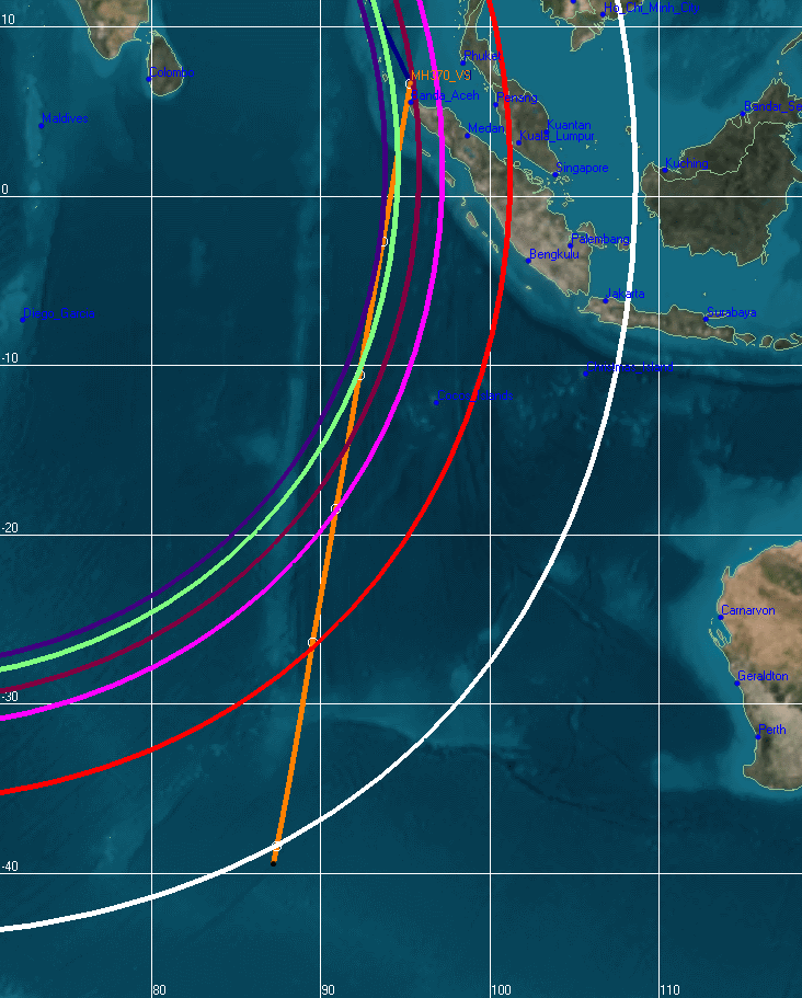
New Search area [6-26-14] is approximately S32E96 between the red and yellow flight paths on the blue final Inmarsat arc.
https://www.facebook.com/178566888854999/photos/pcb.740971779281171/740971732614509/?type=1&theater
It is ~1940 miles SSE from S4E93 — the westernmost point where and when [4:11 or 20:11] the red and yellow flight paths intersect and depart on this NTSB chart.
IOW — the plane had to have been at that point at that time per Inmarsat and the above NTSB chart and logic.
The yellow path leads to New Amsterdam Island where searchers first thought the plane flew — until they realized that it had neither the fuel nor the time to get there.
That projected flight path to New Amsterdam Island is here and shows why it was investigated but then subsequently abandoned — it couldn’t be reached at any speed — autopilot or not:
http://www.duncansteel.com/wp-content/uploads/2014/04/V_2D_2.png
The new search area S32E96 is 4 hours away from S4E93 — the point of decision — at a fixed ~485 mph away.
485mph is the same speed the plane flew at for the previous 3.5 hours by a live pilot to get to this point — so why would he put it on autopilot now — and to nowhere???
Furthermore and most important it is not possible to have the hit the hourly Inmarsat arcs at a fixed speed of 485mph or any other fixed speed???
There is no way that this plane was on autopilot as the officials claim. A live pilot was at the helm from start to finish making decisions.
The problem with the autopilot claim and the new search area is that the plane would have to fly the last hour at ~700mph in order to get to its search area on time — and ~625mph the hour before — meaning that it flew only ~307mph - ~308mph the 2 hours before that.
New Amsterdam Island may have been the pilot’s first choice, but after after 3.5 hours flying he may have realized that it was unreachable with the fuel he had left — and then gone to his backup plan.
Would that backup plan have been a watery suicide or another place to put the plane down???
If a watery suicide is what his backup plan was then why not just stay on course to New Amsterdam Island, let the plane run out of fuel, and drop into the drink just short of there. Why change course?? Just let it fall into the waters short of New Amsterdam Island. There was/is nothing else reachable in that area — nothing. It’s suicide either way — yellow path, red path, in-between path,....
So what would be the purpose in veering off from that heading unless it was to a place where he felt that he could put the plane down and walk or swim away???
At the point of reckoning at S4E93 at 4:11 where would the pilot have looked to head — right on, a little east to nowhere, a little more east to nowhere, further east to nowhere — or well to the east to Christmas Island and the waters south of Java???
Disclaimer: Opinions posted on Free Republic are those of the individual posters and do not necessarily represent the opinion of Free Republic or its management. All materials posted herein are protected by copyright law and the exemption for fair use of copyrighted works.