Skip to comments.
First debris from Japanese earthquake/tsunami reaches Olympic Peninsula (Washington State)
The Peninsula Daily News ^
| December 14, 2011
| Arwyn Rice
Posted on 12/15/2011 12:11:17 PM PST by Stoat
click here to read article
Navigation: use the links below to view more comments.
first previous 1-20, 21-32 last
To: Stoat
I’ve been hearng about this story for months, but not one fly over picture of the aforementioned debris.
21
posted on
12/15/2011 5:10:59 PM PST
by
stockpirate
(Newt and Romney are both Big Government socialists.)
To: Hillarys Gate Cult
IHOP That's just bad!
[laughing anyway.]
22
posted on
12/15/2011 5:12:50 PM PST
by
LucyT
To: Stoat
23
posted on
12/15/2011 5:24:26 PM PST
by
LucyT
To: stockpirate
I’ve been hearng about this story for months, but not one fly over picture of the aforementioned debris.
And no remote sensors dropped into the debris to transmit location / radiation data so that whatever hazard exists (if any) can be better calculated & planned for by emergency services.
Instead, we have to wait until some kid picks up something on the beach, puts it in his mouth & dies of radiation poisoning?
24
posted on
12/15/2011 5:56:04 PM PST
by
Stoat
(If you want a vision of the future, imagine a Birkenstock stamping on a human face... forever)
To: Oatka
“GhostBusters” (first thought.)”
That was what sprung from my lips as I read that post too, and my wife called me a sick-o.
GMTA.
25
posted on
12/15/2011 6:43:19 PM PST
by
rockinqsranch
(Dems, Libs, Socialists, call 'em what you will, they ALL have fairies livin' in their trees.)
To: Stoat
I received this email in response an email I sent alerting NOAA to some debris I found on a beach in Oregon recently that looks to be Japanese in origin.
-J.H
Thank you for contacting us and for your interest and vigilance for Japan tsunami marine debris. As you have probably seen, there is quite a bit of information out there regarding Japan tsunami marine debris, some of it is misleading or not explained properly. We have a web page up on our site with updated information on Japan tsunami marine debris. Any help you can provide in getting our web page and information out there would be greatly appreciated
http://marinedebris.noaa.gov/info/japanfaqs.html.
As you know, it is very difficult to discern debris from the Japan tsunami event. Movement of Japan tsunami marine debris across the North Pacific Ocean this quickly is unlikely, but not outside the realm of possibility. We are working with numerous modelers to figure this out, as well as other partners to see if we can source-identify the debris that has been reported. Our findings will be published on our website, listed above.
If you are interested (and walk your local beach with some frequency), the NOAA Marine Debris Program (MDP) has developed the attached Shoreline Survey Field Guide in order to evaluate and monitor the types and abundance of marine debris at a shoreline site. Effective monitoring of changes in environmental conditions, such as the abundance of marine debris, requires a good deal of forethought.
Monitoring projects should have clearly stated objectives and use agreed-upon methods and field measurements to allow for comparability of data with previous research and that conducted in other areas. Quality marine debris monitoring data can be used to assess spatial and temporal trends and measure the effectiveness of strategies to address the issue.
An electronic data sheet is provided to assist in your data analysis efforts. At this time the MDP does not have the capacity to regularly analyze monitoring data coming in from various groups. We are planning to conduct periodic calls for data; if you are interested in being included in data calls, please send an email to MD.monitoring@noaa.gov.
Please let me know if you have any questions. Best wishes for safe and informative shoreline surveys!
Neal Parry
NOAA Marine Debris
26
posted on
01/31/2012 4:56:50 PM PST
by
Jack Hydrazine
(It's the end of the world as we know it and I feel fine!)
To: Jack Hydrazine
Thank you very much for your important and informative post. I must apologize, I’ve been away from FR for awhile and so haven’t thanked you properly for that reason. Your kindness and forthrightness in keeping other FReepers up to date on this issue is sincerely appreciated. :-)
Fox News has a new article on this debris field which I’ll be posting in a few minutes. Thanks again for your post :-)
27
posted on
02/16/2012 10:18:11 AM PST
by
Stoat
(If you want a vision of the future, imagine a Birkenstock stamping on a human face... forever)
To: All
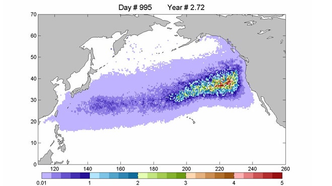
UPDATE
Fox News has some updated information on the debris field which may be of interest to readers, particularly those on the West Coast ;-)
Because it's from Fox News, I'm required to edit it heavily. I'll post the highlights here but going to the original article will be the best thing to do.
25 million tons of tsunami debris floating toward US shores - Fox News
(edit)
But no one's tracking the debris, Jim Churnside, a physicist with the National Oceanic and Atmospheric Agency's (NOAA) Marine Debris Program, told FoxNews.com.
(edit)
Churnside expects models of the debris path from last summer are probably accurate.
The debris is not expected to be radioactive. Carey Morishige, the Pacific Islands Regional Coordinator for the NOAA Marine Debris Program, told science blog Earthsky.org that radioactivity is probably not an issue, since the tsunami carried most of the debris seaward before the failure of Japan’s Fukushima Daiichi nuclear reactor.
(edit)
(The pic below is a computer model/projection of the expected path....not an actual indicator of the current debris field position. More pics and a video are available at the Fox site.)
28
posted on
02/16/2012 10:38:31 AM PST
by
Stoat
(If you want a vision of the future, imagine a Birkenstock stamping on a human face... forever)
To: Stoat
That debris field is larger than the country of Japan...In fact, it’s larger than the western United States. I know they said it’s not an actual indicator, but that’s an absurd depiction.
29
posted on
02/16/2012 10:47:31 AM PST
by
dragnet2
(Diversion and evasion are tools of deceit)
To: Stoat
That debris field is larger than the country of Japan...In fact, it’s larger than the western United States. I know they said it’s not an actual indicator, but that’s an absurd depiction.
30
posted on
02/16/2012 10:47:53 AM PST
by
dragnet2
(Diversion and evasion are tools of deceit)
To: dragnet2
Indeed....I guess the computer model is including projections of the maximum spread of even the smallest particles of debris, and so it looks absolutely overwhelming to the entire West Coast when the reality is quite different.
31
posted on
02/16/2012 10:57:56 AM PST
by
Stoat
(If you want a vision of the future, imagine a Birkenstock stamping on a human face... forever)
To: All; KevinDavis
I'm noticing that the overall shape of the debris field, as suggested by the computer model, is rather similar to that of "The Doomsday Machine" from the Star Trek episode of the same name.
Coincidence, or alien plot?
Footage of The Doomsday Machine in action here:
http://www.youtube.com/watch?v=hj1idKXAiCk
32
posted on
02/16/2012 12:33:44 PM PST
by
Stoat
(If you want a vision of the future, imagine a Birkenstock stamping on a human face... forever)
Navigation: use the links below to view more comments.
first previous 1-20, 21-32 last
Disclaimer:
Opinions posted on Free Republic are those of the individual
posters and do not necessarily represent the opinion of Free Republic or its
management. All materials posted herein are protected by copyright law and the
exemption for fair use of copyrighted works.
FreeRepublic.com is powered by software copyright 2000-2008 John Robinson