Skip to comments.
Tropical Depression 7
NOAA/NHC ^
| 08/25/2008
| NOAA/NHC
Posted on 08/25/2008 8:27:52 AM PDT by NautiNurse
click here to read article
Navigation: use the links below to view more comments.
first previous 1-20 ... 341-360, 361-380, 381-400 ... 581-592 next last
To: NautiNurse
The GOM New Orleans Region and Port Arthur Region O&G installations are projected at high risk from Gustav per Rigzone. Gustav projected to make landfall between tracks of Hurricane Rita and Katrina in the middle of LA. Still projecting GOM CAT 3+/4-. Time will tell........
Gulf Coast Offshore Oil Platform Maps
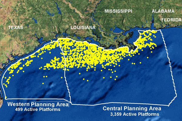
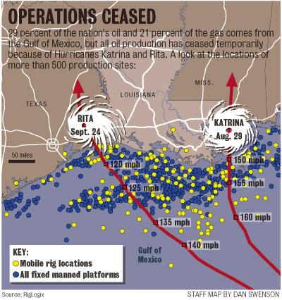
PDF maps of the major locations of the 6,659 active and removed oil platforms, of which 819 are still fully manned. These maps cover the Gulf Coast oil rigs and offshore pipelines of Alabama, Louisiana, Mississippi, and Texas. Many of these platforms and oil rigs were either sunk or set adrift after hurricane Katrina and Rita struck this area of the gulf in August/Sept. 2005 (Along with Hurricane Ivan in 2004 - fla) . The Gulf of Mexico normally pumps about 1.5 million barrels per day (bpd) of US crude, a quarter of domestic output and equivalent to nearly 2 percent of global oil production. As we now know, any disruption to this area can cause oil prices to dramatically increase.
361
posted on
08/27/2008 4:26:23 AM PDT
by
flattorney
(See my comprehensive FR Profile "Straight Talk" Page)
To: NautiNurse
...drooled at the possibility a killer hurricane might strike NOLA during the RNC Convention this year...They should worry about the weather at their own outdoor Thursday event!
To: LSUfan; NautiNurse
I’m going to Wal Mart today and stock up on supplies. *sigh*
(We’re in the Baton Rouge, Louisiana area)
To: trillabodilla
I guess we’re also going to have to secure our camp in Pierre Part, Louisiana; it’s a lot closer to the coast.
*sigh*
To: trillabodilla
I went yesterday. Didn’t have much to get. I have been keeping a stockpile ever since Katrina.
365
posted on
08/27/2008 4:36:38 AM PDT
by
LSUfan
To: trillabodilla
Good idea to get an early start on the storm rations.
366
posted on
08/27/2008 4:46:16 AM PDT
by
NautiNurse
(Plants are people too)
Tropical Storm Public Advisory
Statement as of 8:00 am EDT on August 27, 2008
...Gustav continues to bring heavy rain squalls to Haiti...
a Tropical Storm Warning is in effect for Haiti from the Dominican
Republic-Haiti border westward to Le Mole St Nicholas. A Tropical
Storm Warning means that tropical storm conditions are expected
within the warning area within the next 24 hours.
A tropical storm watch is in effect for Haiti from east of Le Mole
St Nicholas to the northern Haiti/Dominican Republic border. A
tropical storm watch means that tropical storm conditions are
possible within the watch area...generally within 36
hours.
A Hurricane Watch and a Tropical Storm Warning are in effect for
Jamaica.
A Hurricane Warning remains in effect for Cuba for the provinces of
Guantanamo...Santiago de Cuba...and Granma.
A Hurricane Watch remains in effect for the Cuban provinces of Las
Tunas and Holguin and all of the Cayman Islands.
Interests in central and western Cuba should closely monitor the
progress of Gustav.
For storm information specific to your area...including possible
inland watches and warnings...please monitor products issued
by your local weather office.
At 800 am EDT...1200z...the center of Tropical Storm Gustav was
located near latitude 18.8 north...longitude 73.7 west or about 90
miles...150 km...west of Port au Prince Haiti and about 120 miles...
195 km...southeast of Guantanamo Cuba.
Gustav is moving toward the northwest near 5 mph...7 km/hr. A turn
toward the west-northwest is expected later today. A west-
northwest to west track is forecast during the next day or two with
a gradual increase in forward speed. On the forecast
track...Gustav should pass between Jamaica and the southeastern
coast of Cuba on Thursday.
Maximum sustained winds remain near 60 mph...95 km/hr...with higher
gusts. Slow strengthening is forecast and Gustav could regain
hurricane strength on Thursday once it moves away from Haiti.
Tropical storm force winds extend outward up to 50 miles...85 km
from the center.
Minimum central pressure estimated from Air Force reconnaissance
aircraft data is 997 mb...29.44 inches.
Gustav is expected to produce total rainfall accumulations of 6 to
12 inches over Hispaniola...eastern Cuba...Jamaica...and the Cayman
Islands...with isolated maximum amounts of up to 25 inches
possible. These rains will likely produce life-threatening flash
floods and mud slides.
Coastal storm surge flooding of 1 to 3 feet above normal tide levels
along with large and dangerous battering waves can be expected in
areas of onshore winds in the Tropical Storm Warning area.
Repeating the 800 am EDT position...18.8 N...73.7 W. Movement
toward...northwest near 5 mph. Maximum sustained winds...60
mph. Minimum central pressure...997 mb.
The next advisory will be issued by the National
Hurricane Center at 1100 am EDT.
$$
Forecaster Pasch/Rhome
367
posted on
08/27/2008 4:50:13 AM PDT
by
NautiNurse
(Plants are people too)
To: NautiNurse; LSUfan
Yep, gotta make sure we have enough chocolate!
To: abb; abbi_normal_2; aberaussie; alancarp; Alas Babylon!; Alia; Alice in Wonderland; ...
TS Gustav has lost some strength over Haiti. This is expected
to be temporary. Winds 60mph...Pressure 997 mb. Moving NW
at 5mph. 
On/Off Hurricane List Mash Here-->
369
posted on
08/27/2008 4:55:30 AM PDT
by
NautiNurse
(Plants are people too)
To: NautiNurse
370
posted on
08/27/2008 4:58:33 AM PDT
by
WorkerbeeCitizen
(Seinfeld was a show about nothing - so is Obama.)
To: trillabodilla
We raided the local Albertsons for hurricane chocolate last week. They are closing all their stores, and candy was marked down 40%. Fortunately, our Albertsons was bought by Publix.
371
posted on
08/27/2008 4:58:49 AM PDT
by
NautiNurse
(Plants are people too)
To: NautiNurse
I was sickened last night listening to James Carville and the CNN libs as they drooled at the possibility a killer hurricane might strike NOLA during the RNC Convention this year.I say "bring it on" The difference this year is Jindal. You won't see the same inaction and deer in the headlights freezeup of the governor this time around.
372
posted on
08/27/2008 5:05:49 AM PDT
by
NonValueAdded
(Rest In Peace, Capt. Ed "Too Tall" Freeman (1928-2008))
To: NautiNurse
Thank you for the updates NN.
373
posted on
08/27/2008 5:09:48 AM PDT
by
prairiebreeze
( Our troops DESERVE BETTER than Barack Hussein Obama!!)
To: NautiNurse
374
posted on
08/27/2008 5:11:18 AM PDT
by
blam
To: NautiNurse
To: NautiNurse
Appreciate the ping - as always.
376
posted on
08/27/2008 5:58:18 AM PDT
by
Freedom'sWorthIt
(Tony Snow founnd out - to live is Christ, to die is gain....Thanks be to God for Tony's life!)
To: NautiNurse
Starting to get the “shotgun” effect from the models, in short, everybody duck!
377
posted on
08/27/2008 5:59:08 AM PDT
by
SouthTexas
(Invert the 5-4 and you have no rights.)
To: NautiNurse
gag - I did not hear them say that though was listening to CNN (sort of) due to being with liberal siblings right now who love CNN. But I am sure they have those exact thoughts. That they would express them openly tells you how seriously mentally ill they are. Or is it just how evil they are?
378
posted on
08/27/2008 6:02:27 AM PDT
by
Freedom'sWorthIt
(Tony Snow founnd out - to live is Christ, to die is gain....Thanks be to God for Tony's life!)
To: Uncle Ike
****trail of breadcrumbs****
379
posted on
08/27/2008 6:04:56 AM PDT
by
Uncle Ike
(Sometimes I sets and thinks, and sometimes I jus' sets.........)
To: NautiNurse
I’d sure love to see a transcript or video of this. The Republicans could use this to hurt them. I just can’t believe that they’d welcome a hurricane to damage a political convention.
Navigation: use the links below to view more comments.
first previous 1-20 ... 341-360, 361-380, 381-400 ... 581-592 next last
Disclaimer:
Opinions posted on Free Republic are those of the individual
posters and do not necessarily represent the opinion of Free Republic or its
management. All materials posted herein are protected by copyright law and the
exemption for fair use of copyrighted works.
FreeRepublic.com is powered by software copyright 2000-2008 John Robinson