Free Republic
Browse · Search
Bloggers & Personal
Topics · Post Article

To: E. Pluribus Unum

21 posted on 01/11/2020 1:53:06 PM PST by Lonesome in Massachussets (Every election, more or less, is an advance auction of stolen goods. - H. L. Mencken)
[ Post Reply | Private Reply | To 1 | View Replies ]


To: Lonesome in Massachussets; Candor7
I do not understand the graphic you posted, it shows that between 1935-1940 less than 20K hectares were affected. The Forestry Commission site has:

VIC GOV HISTORY. LINK

From December 1938 to January 1939, peaked on Friday 13 January – Black Friday. The fires burned 1.5 to 2 million hectares, including 800,000 hectares of protected forest, 600,000 hectares of reserved forest and 4,000 hectares of plantations. They killed 71 people and destroyed more than 650 buildings and the township of Narbethong. The fires affected almost every section of Victoria. Areas hardest hit included Noojee, Woods Point, Omeo, Warrandyte and Yarra Glen. Other areas affected included Warburton, Erica, Rubicon, Dromana, Mansfield, the Otway Ranges and the Grampian Ranges. The findings of the Royal Commission held after the fires were significant in increasing fire awareness and prevention throughout Australia.

24 posted on 01/11/2020 3:04:04 PM PST by Fred Nerks (fair dinkum!)
[ Post Reply | Private Reply | To 21 | View Replies ]

To: Lonesome in Massachussets

Wikipedia has a list of fires, and it does not align with your chart.

https://en.wikipedia.org/wiki/Bushfires_in_Australia#Major_bushfires_in_Australia

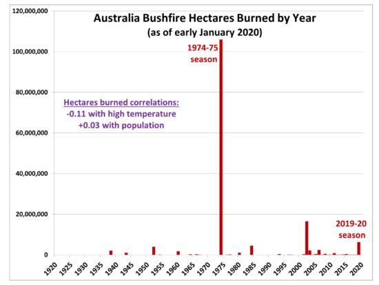
It shows that the 1974/75 fires and the 2002 fires covered more acreage than the current fires.


27 posted on 01/11/2020 3:15:06 PM PST by UnwashedPeasant (Trump is solving the world's problems only to distract us from Russia.)
[ Post Reply | Private Reply | To 21 | View Replies ]

Free Republic
Browse · Search
Bloggers & Personal
Topics · Post Article


FreeRepublic, LLC, PO BOX 9771, FRESNO, CA 93794
FreeRepublic.com is powered by software copyright 2000-2008 John Robinson