Free Republic
Browse · Search
Bloggers & Personal
Topics · Post Article

To: fso301

Unless they somehow “triangulated” the maintenance pings(doubtful), they wouldn’t give a heading, just time. How did they arrive at a heading towards the South Indian Ocean? (~1400 miles SW of Perth) I don’t think I read anything about how the NTSB?? arrived at a heading.


11 posted on 03/21/2014 3:57:56 AM PDT by Drago
[ Post Reply | Private Reply | To 2 | View Replies ]


To: Drago
I believe the arcs were indeed arrived at by triangulation from two Inmarsat satellites.

It would be at the edge of the coverage range for the second satellite, but it appears from the arcs that they must have recovered signals received by a second satellite.

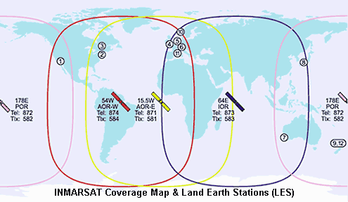
Knowing the time the pings were issued (e.g., 6:11:0000, 7:11:0000, 8:11:0000) and the time the pings were received by each satellite (e.g., 6:11:0002, 7:11:0008, 8:11:0013) they can compute an approximate distance x from satellite 1 and an approximate distance y from satellite 2.

The problem is the satellites sit over the equator. Therefore there are two solutions to the problem object Z is distance x from satellite 1 and y from satellite 2. One is to the north of the equator, and one is to the south of the equator.

42 posted on 03/21/2014 9:16:06 AM PDT by Meet the New Boss
[ Post Reply | Private Reply | To 11 | View Replies ]

Free Republic
Browse · Search
Bloggers & Personal
Topics · Post Article


FreeRepublic, LLC, PO BOX 9771, FRESNO, CA 93794
FreeRepublic.com is powered by software copyright 2000-2008 John Robinson