To: Travis McGee
Here's something that I consider essential for anyone who may be thinking of mobility or who may need to bug out.
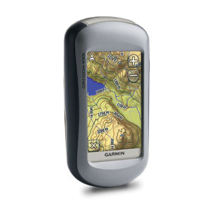
With a large enough microSD, it will hold a Topo of an entire continent. The Garmin satellite images from their download service are amazingly accurate. I've found them to be within 10' while driving around my property on an ATV and the resolution allows you to view down to individual tree level. I have the Oregon model since it's small enough to put in my shirt or pants pocket. Uses 2 AA rechargeable batteries that last over 12 hours.
212 posted on
07/16/2011 9:26:14 AM PDT by
Errant
To: Errant
What makes you so convinced that those services will still be available? If the electricity goes off, there will be nothing to relay the data from the satellite network.
213 posted on
07/16/2011 9:32:41 AM PDT by
PSYCHO-FREEP
(Always Remember You're Unique.......(Just Like everyone Else.))
To: Errant
If the situation has deteriorated to such an extent that fleeing becomes necessary, why do you believe Garmin’s GPS service would still be functional?
It may or may not be. Leaving familiar terrain in a societal breakdown sounds suicidal to me. The only way I’d consider it is if remaining where I am removed all doubt and the mere possibility elsewhere would be an improvement.
FreeRepublic.com is powered by software copyright 2000-2008 John Robinson