
Posted on 02/26/2010 7:43:50 PM PST by jay1949
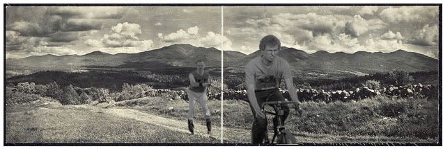
While perusing the Library of Congress archives, I ran across a beautiful old panoramic shot of a dirt road and stone wall viewed against a range of mountains. The scene is very reminiscent of the Valley of Virginia or the Cumberland Valley in Maryland-Pennsylvania, but evidently the attribution information has been lost. Perhaps the profile of the mountains in the background can provide the location -- if anyone out yonder recognizes this place, please let me know.
(Excerpt) Read more at backcountrynotes.com ...
Are you kidding?
That photo cold be 75 years old or more. That wall wont be around and it’s even possible that those mountains have been removed for want of coal and/or iron. The valley could be underwater.
Colorado?
It seems to be in an area that does not have much color. I would think that would make it stand out as pretty memorable.
Thailand?
I don’t know about the mountains but I’m sure I’ve seen those clouds somewhere before.
Pretty scene, but those would be called foothills out West here, not mountains.
The size and shape of the mountains, and the lack of heavy forest, looks very much like somewhere along the Valley of Virginia.
That looks like a European Swallow carrying a coconut, so it must be India.
Lokks like part of the Shanendoah river valley.
Jay, It looks very much like Cades Cove in the Great Smoky Mountains in TN. I don’t know how to post a picture on here, but the view I find that is most similar can be seen here http://www.pbase.com/image/23760099
Rocks for wall look old and weathered too. Gate in wall looks newer, however, so I think photo is newer than we might think.
In addition, tracks in road look more like rubber tire than wooden wheel.
Last “age” giveaway is the depth of field. Camera lens was as small f-stop (aperture) to allow objects close to camera and far away from camera to all be in focus, although this could be achieved with a small aperture, “slow” film and a 1/4 or 1/2 second exposure.
Film does not seem to be grainy, so again seems to be more modern.
Darkwing104 is good at this photo stuff.
Also, Aeronautical Sectional charts at SkyVector.com are topographical maps, so if you get close to where you think it is, you can confirm mountain patterns with elevations shown on pilot's Sectional charts there.
FYI
WV, I was going to say that too!
mrs
Rock wall in Thailand?
Most old “brownie” style cameras had a pinhole aperture setting. And all film back then was slow.
Best guess. Cumberlands, or upstate NY, VT, NH, late summer, about noon, looking Southeast. But it’s all a guess.
Disclaimer: Opinions posted on Free Republic are those of the individual posters and do not necessarily represent the opinion of Free Republic or its management. All materials posted herein are protected by copyright law and the exemption for fair use of copyrighted works.