
Posted on 10/07/2018 10:07:16 AM PDT by NautiNurse
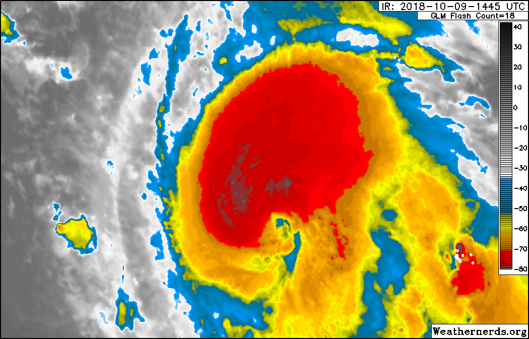
Tropical Storm Mitchell: The NHC has issued a Public Advisory Update indicating Tropical Storm Mitchell has formed about 90 miles South of Cozumel, Mexico. Current forecast predicts Mitchell will reach hurricane strength in the Gulf of Mexico before making landfall in the Northern GOM. Landfall is estimated by 96 hours.

Gulf of Mexico Satellite Channels

Public Advisories
NHC Discussions
NHC Local Weather Statements/Radar Key West FL
NHC Local Weather Statements/Radar New Orleans, LA
NHC Local Weather Statements/Radar Mobile AL/Pensacola FL
NHC Local Weather Statements/Radar Panama City, FL
NHC Local Weather Statements/Radar Tallahassee, FL
NHC Local Weather Statements/Radar Tampa Bay, FL
I hope Michael weakens and you aren’t affected. CSB is our favorite vacation spot - we are headed down next week (I hope)
Anyone hear or read if they are getting aircraft moved out of NAS P’Cola?
This is all I can find:
The Navy said Naval Air Station Pensacola , Corry Station and Saufley Field would curtail normal operations and close the installations to visitors and non-critical personnel at 2 p.m. Tuesday. The Navy said all facilities onboard the base will remain closed through Wednesday.
The U.S. Air Force Special Operations Command at Hurlburt Field announced Tuesday it would close starting at 6 p.m. Tuesday until further notice due to Hurricane Michael.
Eglin Air Force Base has limited non-essential operations in advance of Hurricane Michael. The base said Tuesday that it anticipates sustained winds of 40 miles per hour or higher around 8 p.m. When sustained winds reach 68 miles per hour or higher, the base will close its gates and cease all outside operations, the base said.
Thank you very much for the information!
Wow~
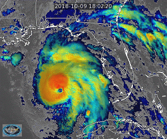
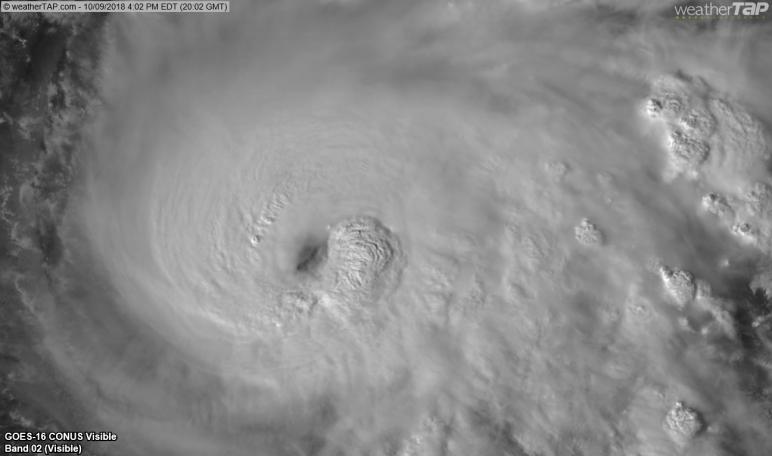
With the temps in the Gulf, Michael could turn into a very nasty hurricane.
And I here by disavow and connection to the name Michael.
5.56mm
I watched that and it was awesome.
Did you see the video of the guys (and gals) saving the manatees? In Hillsbourgh bay?
5.56mm
Hurricane Michael
Realtime Maps
Yes—Manatees were beached when the Sarasota Bay emptied too!

On/Off Hurricane List Mash Here--> 
Jesus Christ a King of Glory has come in Peace. +
God became man, + and the Word was made flesh. +
Christ was born of a Virgin.+
Christ suffered.+
Christ was crucified.+
Christ died.+
Christ rose from the dead.+
Christ ascended into Heaven. +
Christ conquers. +
Christ reigns. +
Christ orders. +
May Christ protect us from all storms and lightning.+
Christ went through their midst in Peace, +
and the Word was made flesh. +
Christ is with us with Mary. +
Flee you enemy spirits because the Lion of the
Generation of Juda, the Root of David, has won. +
Holy God! + Holy Powerful God! + Holy Immortal God! +
Have mercy on us.
Amen.
Thanks for the thread, pings, and updates. Although I’m 100 miles north of the Gulf in Dothan, it looks like Michael is planning to pass right over my house with pretty incredible winds. Prayers for all in his path - stay safe FRiends.
bump
Harvey, Irma and Maria soon to become last year’s news. Finally. Godspeed to all in my old stomping grounds of PCB and extreme SE Alabama.
Oh man, this sucker is going to be bad.
And strengthening as it comes closer.
Good luck to you too. Hoping you don’t have tall trees near your home. Check your neighbors’ yards for anything loose that may become missiles.
Yes, it is the rock breakwater south of Scallop Cove.
Disclaimer: Opinions posted on Free Republic are those of the individual posters and do not necessarily represent the opinion of Free Republic or its management. All materials posted herein are protected by copyright law and the exemption for fair use of copyrighted works.