Louie Goo-Tee-Air-Eezzz' 'hood.
Posted on 12/09/2017 12:03:33 PM PST by SMGFan
The Supreme Court late Friday agreed to hear a challenge to the lines of a Maryland congressional district that were drawn by Democrats. The court has already heard a partisan gerrymandering case from Wisconsin, where Republicans drew the state legislative map.
In the Maryland case, the plaintiffs are challenging the congressional map enacted by the Maryland General Assembly after the 2010 Census, arguing that it’s a partisan gerrymander that favors the Democrats.
At issue is the state’s 6th District, which has been represented by a Democrat since the 2011 redistricting. Longtime GOP Rep. Roscoe G. Bartlett lost his 2012 re-election to Democrat John Delaney by more than 20 points after winning the seat fairly easily since 1992.
(Excerpt) Read more at rollcall.com ...
All gerrymandering can be solved with each state making a law that says all districts must be rectangles with straight lines on every border.
Odds are a trillion to one it will ever happen. But that’s one of the toys on my dream world shelves.
I don’t get it. Shouldn’t the party in power in the state draw the districts? Why is this a FEDERAL question? The feds determine the population because of the Constitutional requirement of a census.
I don’t see fed involvement anywhere in district drawing unless one “finds” one in the 14th amendment.
They also need to look into the liberal BS in my now former home state of Arizona. Obammie sent his own hit squad to Arizona to screw up Arizona. Somebody needs to go to jail.
Louie Goo-Tee-Air-Eezzz' 'hood.
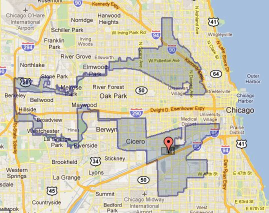
This is how the Democrats destroyed Illinois.
Take a look at the Maryland district map. It looks sort of like a monkey puked on a map and they drew circles around the chunks. The sole Republican member of congress’s district wraps around my town because they wanted to preserve us for the liberal.
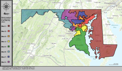
Maryland has eight CDs.
To the east (across the Chesapeake), to the south east (this side of the Chesapeake) to the west, north of Baltimore City, it is Republican. The mid-section of the state, where most Marylanders live, is very Democrat.
Prior to the most recent gerrymander, the western part formed the basis of one district in which a Republican was competitive, and the east part (again, across the Chesapeake) the basis of another.
The southeastern part formed the basis of a third district that in theory the Republicans could compete; but, in fact, not really.
In the most recent gerrymander, the Democrats stretched the western district into the D.C. suburbs, to make it tilt Democrat; and pushed a Washington, D.C. suburban districts out to the west and to north to each pick up Republican voters but not enough to make the district competitive.
The result of this and prior gerrymandering is the ridiculous districts you see in the following map. The Purple district used to be reasonably compact, with a basis in Montgomery County, an affluent, mostly white Democrat district. You can easily see the projection of this county to the north and west.
Other districts are even more ludicrous. The orange district is a like links of sausage, starting on the west shore of the Chesapeake in the vicinity of Annapolis, twisting to the west to the D.C. suburbs, then snaking around the blue district to pick up some more voters in the suburbs immediately north of Baltimore.
The center of the state looks like some kind of obscene gay orgy with various districts thrusting appendages into various apertures of other districts, but being as this is Maryland, we can presume that it’s all consensual.
That’s pathetic.
Congressional districts should be drawn with the shortest length of boundary line to enclose the proper number of people. The only “demographic” that should matter, being in the same State aside, is “person” ... though allowances could be made to separate distinct municipalities so these don’t get too chopped up. It could be done by computer.
This would result in somewhat irregular, lumpish shapes and would eliminate gerrymandering entirely.
We should also greatly decrease the target size (population) of Congressional districts. Just because there’s a room in a historic building that doesn’t mean we should have to use it. Let them level some worse than useless law and lobby firms in DC to make room for a new hall.
Unbelievable.
The case the Court had before it that’s been argued challenges a pro-GOP redistricting; this one challenges a pro-Dem. redistricting. Looks to me like the Court will consolidate both cases and decide them as a pair in an effort to construct a precedent that will apply to all future redistricting.
Can’t do that.
Might disenchise Blacks.
Guilty as charged.

or at least bounded by county lines or rivers or cities, not these computer generated districts that wind carefully up and down streets but look like spaghetti dropped onto a plate.
Referendum Petition Congressional Districting Plan (Ch. 1 of the 2011 Special Session)
Establishes the boundaries for the State’s eight United States Congressional Districts based on recent census figures, as required by the United States Constitution.
Understandably people not intimately informed with the actual meaning voted for this statement, written by the veto-proof legislature. The US Constitution only says that districts must be contiguous and about the same population. Thus Maryland’s map that sometimes runs for miles down a single street to connect regions nowhere near each other satisfied the Constitution. Of course the leftist media did not show the map to the citizens who would have been horrified by it. My point is that in leftist controlled states with leftist media, it is easy to fool people.
Where Bongino would have won handily
Disclaimer: Opinions posted on Free Republic are those of the individual posters and do not necessarily represent the opinion of Free Republic or its management. All materials posted herein are protected by copyright law and the exemption for fair use of copyrighted works.