Astronomy Picture of the Day
Discover the cosmos! Each day a different image or photograph of our fascinating universe is featured, along with a brief explanation written by a professional astronomer.
2003 September 16 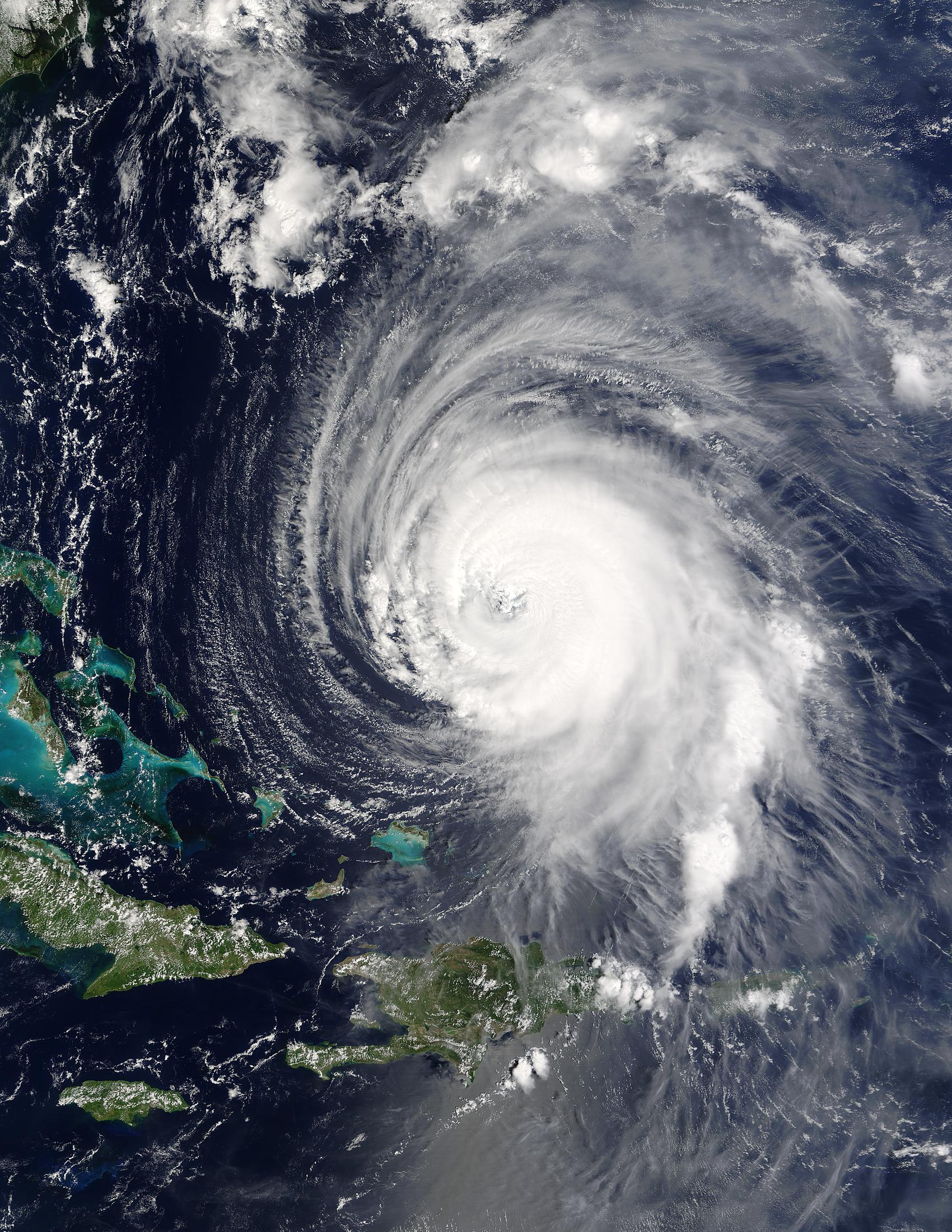
Posted on 09/15/2003 10:33:11 PM PDT by petuniasevan
Discover the cosmos! Each day a different image or photograph of our fascinating universe is featured, along with a brief explanation written by a professional astronomer.
2003 September 16
Explanation: Where will Hurricane Isabel go? One of the stronger storm systems of modern times appears headed for one the more populated seaboards on planet Earth -- the east coast of the USA. Hurricane Isabel, pictured yesteday as it passed east of the Bahamas, has flirted with category 5 status, the most powerful hurricane category. Hurricanes are huge swirling storms with cloud systems typically larger than a state. Tropical cyclones, called hurricanes in Earth's Western Hemisphere and typhoons in the Eastern Hemisphere, get their immense energy from warm evaporated ocean water. As this water vapor cools and condenses, it heats the air, lowers pressure and hence causes cooler air to come swooshing in. Winds can reach over 250 kilometers per hour and become very dangerous. Much remains unknown about cyclones, including how they are formed and the exact path they will take.
"Swooshing?" Is this a new technical term? Nike endorsement?
Don't expect the storm to fizzle (wishful thinking); as it crosses the Gulf Stream it might maintain or even strengthen a bit. Though storms like this are unpredictable, this one seems poised to strike somewhere between South Carolina and New Jersey, with most likelihood being just southwest of Chesapeake Bay. Don't rely on that Bay Tunnel for escape Wednesday!
I don't want to read your name on the list of fatalities. Stay safe, stay forewarned, evacuate before you are trapped.
000 WTNT33 KNHC 160232
TCPAT3
BULLETIN
HURRICANE ISABEL ADVISORY NUMBER 40
NWS TPC/NATIONAL HURRICANE CENTER MIAMI FL
11 PM AST MON SEP 15 2003
...HURRICANE ISABEL CONTINUES MOVING NORTHWESTWARD...
INTERESTS FROM THE CAROLINAS NORTHWARD TO SOUTHERN NEW ENGLAND...ALONG THE COAST AND INLAND...SHOULD CLOSELY MONITOR THE PROGRESS OF ISABEL.
AT 11 PM AST...0300Z...THE CENTER OF HURRICANE ISABEL WAS LOCATED NEAR LATITUDE 26.1 NORTH...LONGITUDE 70.2 WEST OR ABOUT 710 MILES...1140 KM...SOUTH-SOUTHEAST OF CAPE HATTERAS NORTH CAROLINA. THIS POSITION IS ALSO ABOUT 480 MILES...770 KN...EAST OF NASSAU IN THE BAHAMAS.
ISABEL IS MOVING TOWARD THE NORTHWEST NEAR 7 MPH ...11 KM/HR...AND THIS GENERAL MOTION IS EXPECTED TO CONTINUE FOR THE NEXT 24 HOURS.
MAXIMUM SUSTAINED WINDS HAVE DECREASED TO NEAR 120 MPH...195 KM/HR...WITH HIGHER GUSTS. SOME SLIGHT ADDITIONAL WEAKENING IS POSSIBLE ON TUESDAY.
HURRICANE FORCE WINDS EXTEND OUTWARD UP TO 105 MILES...165 KM... FROM THE CENTER...AND TROPICAL STORM FORCE WINDS EXTEND OUTWARD UP TO 200 MILES...325 KM.
THE ESTIMATED MINIMUM CENTRAL PRESSURE IS 949 MB...28.02 INCHES.
LARGE OCEAN SWELLS AND DANGEROUS SURF CONDITIONS ARE ALREADY BEING EXPERIENCED ALONG PORTIONS OF THE U.S. MID-ATLANTIC COASTLINE. THESE CONDITIONS WILL ALSO CONTINUE OVER PORTIONS OF THE GREATER AND LESSER ANTILLES...THE TURKS AND CAICOS ISLANDS...AND THE ISLANDS OF THE BAHAMAS FOR THE NEXT FEW DAYS.
REPEATING THE 11 PM AST POSITION...26.1 N... 70.2 W. MOVEMENT TOWARD...NORTHWEST NEAR 7 MPH. MAXIMUM SUSTAINED WINDS...120 MPH. MINIMUM CENTRAL PRESSURE... 949 MB.
FOR STORM INFORMATION SPECIFIC TO YOUR AREA...PLEASE MONITOR PRODUCTS ISSUED BY YOUR LOCAL WEATHER OFFICE.
THE NEXT ADVISORY WILL BE ISSUED BY THE NATIONAL HURRICANE CENTER AT 5 AM AST.
FORECASTER LAWRENCE

| A weakened Isabel is downgraded 9/15/2003 7:29 P.M. Tom Moore, Sr. Meteorologist, The Weather Channel |
| Isabel has weakened, but remains a major (category 3) hurricane on the Saffir-Simpson scale. The storm is being negatively infulenced by a trough of low pressure to its northwest. Outflow inhibition and dry air intrusion has weakened the storm, especially on the western side. The storm may strengthen a bit over the next day or so as the trough to the northwest lifts out and the storm heads for the warm Gulf Stream waters. Landfall should occur by Thursday. The exact spot of landfall may be difficult to predict due to the extreme angle at which the storm could be approaching the coast, especially if it stays out to sea north of Cape Hatteras. A very tiny change in the direction of movement could shift its landfall by a hundred miles or more. Areas from the Middle Atlantic Coast to North Carolina should be on alert, however. Although Isabel is not a particularly large hurricane, its wind field will expand dramatically as it nears the U. S. and encounters a building high pressure area over the Northeast. Thus, even though the strongest winds should occur someplace along the Mid-Atlantic coast (wherever Isabel comes ashore), gales eventually could pound beaches as far north as Maine. In the meantime, the first effects will be building surf and rip currents along the Eastern Seaboard. No high surf warnings have yet been issued, but that may change soon. Large swells and dangerous surf are currrently battering portions of the Bahamas, Turks and Caicos Islands and the Greater and Lesser Antilles. |
|
|

TOPSAIL BEACH, N.C. - Residents up and down the East Coast boarded up windows Monday and the military ordered ships and planes out of harm's way as Hurricane Isabel churned toward land with 120 mph winds.

Forecasters said Isabel could hit anywhere from North Carolina to New Jersey late Thursday or early Friday.
Even though the storm was still at least three days away, coastal residents and military installations were already taking precautions.
Vice Adm. Gary Roughead, commander of the U.S. Second Fleet, ordered 40 ships and submarines based in the Norfolk, Va., area to head to sea Tuesday to avoid being battered against piers by high winds.
About 30 vessels, including two aircraft carriers, that cannot be moved were "being battened down as tight as possible, tightening all the hatches," said Lt. Scott McIlnay, a Navy spokesman.
Also Tuesday, the Air Force will fly about 60 planes from Langley Air Force Base in Hampton to Grissom Air Force Base in Indiana, said Capt. Jeff Glenn, spokesman for the 1st Fighter Wing at Langley.
Virginia Gov. Mark R. Warner declared a state of emergency, putting National Guardsmen, state police and transportation crews on full alert.
At Taylor's Do-It Center hardware store in Norfolk, Va., assistant manager George Wolf said he was swamped with customers as soon as the doors opened at 8 a.m., and large batteries and flashlights were sold out.
"You would have thought we were giving stuff away," Wolf said. "I just sold my last 30 sheets of plywood."
Stevens Hardware in Annapolis, Md., ran out of batteries, flashlights, lamp oil, tape, camping lamps, can openers, plastic sheeting and candles before noon Monday, said manager Mike Stevens.
"A lot of people are calling for generators. I don't think there's a generator in Annapolis to be bought," Stevens said.
Officials in Baltimore canceled leave for staffers in the police, fire, transportation and public works departments.
"Right now we are preparing ... as if the storm is coming right at us," Mayor Martin O'Malley said.
At 11 p.m. EDT, Isabel was centered about 710 miles southeast of Cape Hatteras, and was moving northwest at about 7 mph.
Isabel weakened Monday to a Category 3 storm with sustained wind blowing at 120 mph with higher gusts, the National Hurricane Center (news - web sites) said. On Sunday, Isabel's top wind hit 160 mph, making it a Category 5 storm.
"It has been weakening," said Eric Blake, a meteorologist with the Miami-based center. "That's good for the people of the East Coast, but by no means should anyone let their guard down. Hurricanes are notorious for gaining strength as they cross the Gulfstream. Even if it weakens to a Category 2 hurricane, there's still a lot of potential for danger."
Isabel is the first major hurricane to threaten the mid-Atlantic since Floyd wreaked havoc on the East Coast in September 1999, leading to 56 deaths.
All 921 residents of Ocracoke Island in North Carolina's vulnerable Outer Banks were ordered to begin evacuating Monday afternoon. A line quickly formed at the ferry dock.
In other islands on the outer banks, residents started boarding windows, moving their vessels inland and checking up on their generators.
Kay Burros and Anne Troutman decided it was time to check their 5,000-watt home generator at Surf City.
"We've had it about 3 years, but haven't cranked it up in a while. It's been so long, we have to read the instructions," Burros said.
Up the coast in Dover, Del., B.J. Whittaker snapped up 10 sheets of plywood at a Lowe's home improvement store. "I can't do anything if the roof blows off, but I can keep my windows from getting broken," he said.
Emergency officials in central and eastern Pennsylvania started planning for the growing likelihood that Isabel or its remnants would bring high wind and heavy rain into the state by Friday morning.
Pennsylvania already has had a wetter than normal summer, and hundreds of people were evacuated Monday in West Chester, Pa., west of Philadelphia, because of extensive flooding caused by more than 8 inches of rain overnight.
In New Jersey, residents of Bound Brook remembered with dread the $70 million in damage caused by the remnants of Floyd as it swept through in September 1999.
Flood waters 10 feet high nearly put Phyllis Pournaras' diner out of business. But she and others rebuilt with the help of government disaster relief — and the faith that they'd already been through the worst.
"If it floods again, we're done," Pournaras said. "You just don't have the heart to do that again."
Officials at the Miss America (news - web sites) pageant were getting backup power generators and said Saturday's pageant in Atlantic City, N.J., which is to be telecast live, could be postponed if conditions become unsafe.
Meanwhile, a storm swirling over the Pacific Ocean south of Mexico's Baja California peninsula reached hurricane strength Monday afternoon, the National Hurricane Center in Miami reported.
Hurricane Linda's maximum sustained winds reached 75 mph, with the storm centered 290 miles southwest of the southern tip of Baja California. The hurricane was moving northwest at 12 mph and was expected to strengthen slightly overnight.
If someone sets up a thread for reports from the trenches,
I'll send in occasional update from Casa laDentist
until electricity is lost.
Disclaimer: Opinions posted on Free Republic are those of the individual posters and do not necessarily represent the opinion of Free Republic or its management. All materials posted herein are protected by copyright law and the exemption for fair use of copyrighted works.